India Nobody covers India as we do
Maps of IndiaTM
India's No.1 Maps Site Since 1998

Google Web www.mapsofindia.com
  Our Channels :  India | Travel | Business | Automobile   
Newsletter Subscription
Why to Register
e-Mail this Page


Mandya District Map


Mandya, located in the southern part of the state of Karnataka, came into existence in 1939. 
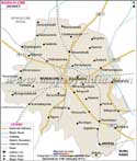
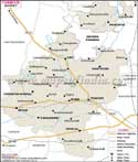
It is located within 76.19' - 76.20' South Latitude and 12.13' - 13.4' East Longitude.

Mandya has a geographical area of 4961 sq .km. As per 2001 Census, Mandya has a population of 17.64 lakhs.

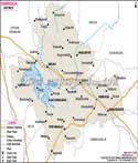
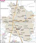
Some of the tourist attractions of this district are
  • Srirangapatna
  • Sriranganatha Temple
  • Daria Daulat Bagh
  • Kokkrebellur


    [Buy this map in different sizes or resolutions, please scroll down for the Order Form.]
    Mandya District Map Tumkur Hassan Mysore Chamrajnagar Bangalore Rural

    For more information contact : solutions@mapsofindia.com

    Disclaimer : All efforts have been made to make this image accurate. However Compare Infobase Limited. and its directors do not own any responsibility for the correctness or authenticity of the same.


  • Karnataka Population


    IndiaMapStore.com An exclusive online store of maps, atlases, travel guides, and CDs.
    India Maps

    Information on Karnataka |  Profile of Karnataka |  Tourism in Karnataka