






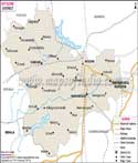
About
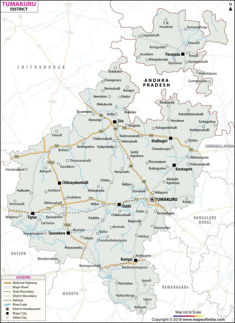
Hidden away in south-east Karnataka and about a 70-km scenic drive away from India's tech city Bengaluru the lively district of Tumkur (formally Tumakuru) exists. Tumkur is special in more ways than one as it not only plays an important role in geographically positioning Karnataka but also about culture and economy. Local folklore is so vivid that one can almost imagine the scene as the name Tumkur changes through each retelling. The first legend says the town was known as "Tumbe Ooru" because a local herb, Tumbe, or Leucas aspera, which is white in color and delicate, carpeted this region in the old days. The second story says tamate, an old percussion musical instrument of folk, used to be played here in the past and that is why the area is still known as Tamate Ooru. The third tale takes us back to the early age of the Chola kings, when the capital of the region changed to Gulur from Tumkur. Because Tumkur is located high above sea level, the local police were allowed to have a Tumaki, a kind of drum, at the foot of the hills, so that in case of any danger people could be warned quickly, and this is how "Tumkur" came to be.
History & Culture
Gangas were the rulers of this area for centuries, leaving behind a very rich heritage of early governance and architectural design. After the Gangas the dominion of the region got the handover to successive strong entities: The Rashtrakutas & Badami Chalukyas. In various parts of the district, there are numerous hero stones (Veeragallu) which bear witness and depict the fierce battles between these empires. The Nolambas: They were the local feudal lords and ruled over large portions of the district and have left behind their finest temple groups like those in Nolambavadi. At the turn of the century in the 17th century, the region got the exposure of Mughal rule, and Sira was declared as the sub-division capital. Though, with time, the land ended up falling within the Kingdom of Mysore ruled by Wodeyars, while with the fall of Tipu Sultan in 1799, the British got the administrative control. After that, in 1832 when Sir Mark Cubbon was the British Commissioner, Tumkur was officially demarcated as a separate administrative unit (District). Srinivasa Charya of the Siddaganga Ashram, popular as the 'Jangama of the Lord', devoted his entire life to the upliftment of the downtrodden, the physically disabled and the intellectually deprived. Karnataka's spiritual heritage is still alive and flourishing through the services of Tumkur residents who remain active members of Tumkur's cultural and spiritual life. Lively cultural activities and festivals mark the life of the people. A very important religious festival is the Guru Mandir Utsav.
Economy
Tumkur's economy is the engine room of industrialization and is a source of livelihood for its people, which combines an agriculture base and highly industrialized zones. Tumkur is an important industrial node that forms an integral part of Bengaluru due to its positioning on the Chennai-Bengaluru Industrial Corridor (CBIC).
Government Sector
Plus private enterprises, the government both at the state and central levels has been instrumental in developing Tumkur economically and socially through massive investment as well as the introduction of various schemes benefiting people mainly those in the rural areas. Infrastructure and Smart City Initiatives: In the hands of the government is the management of Tumakuru Smart City Limited (TSCL) and the major investment into civic infrastructure, sustainable power, water management & smart transit has already taken off.
Public Sector
Hindustan Aeronautics Limited (HAL) Helicopter Factory: The new HAL Helicopter factory is a greenfield facility situated at Gubbi Taluk's Biderehalla Kaval. This factory, the world's largest dedicated to helicopter manufacturing, is a prime example of the nation's defense production capabilities.
Services Sector
Private enterprises in Tumkur are extremely heterogeneous - ranging from huge, multi-layer industrial sectors to small service industries of local communities: Vasanthanarasapura Industrial Area: This place stands among the biggest industrial centers state-wise, as it contains big units for manufacturing of food processing automobiles textiles, and engineering. Mining & Minerals: The abundance of natural resources like iron ore manganese, clay, and granite of the highest quality has paved the way for very big-scale and very active mining and stone cutting operations. The Education Services Sector: There are some outstanding academic centers like Siddaganga Institute of Technology (SIT), a college of higher education of the Sri Siddhartha organization, and Tumkur University.
Tourism
Tumkur is a paradise worth exploring for tourists. If trekking is your thing, you'll have a great time on the trails here, and you can explore old historical landmarks or even experience a spiritual side of life. The district has the most diverse array of amazing vistas for you to discover. A wonderful sight to behold is the Dasoha system which serves to feed hundreds, nay thousands, of students daily by the means of hot food with absolute organization from discipline that flows there. Devarayanadurga Hills: The hill station is so beautiful a sight that you won't get bored easily. It is a great combination of nature beauty and manmade temples; one is situated at the bottom of the hill while the other is on the top. The peak is so high with such nice weather; you can enjoy your life to the full from here. Madhugiri Fort & Monolith: Madhugiri has the second-largest single rock hill in Asia, and it is an exciting experience if you try to climb the steep rock face at its steep slopes. That was where a wonderful historic fort first stood which was built by the Ganga dynasty later on. Hyder Ali further strengthened it with his troops. It will be a very interesting journey and at the end, you will see magnificent views from the hilltop to the surrounding land that the hikers were below. Namada Chilume: In the Devarayanadurga base's forest clearing, there is a forest clearing from which Namada Chilume originates as you look up.
Demographics
To understand the social structure of Tumkur, we look at the vital statistics compiled during the official Census of India. The district has a well-balanced demographic spread, characterized by high literacy rates and an expanding urban footprint. From a demographic point of view, the district mainly consists of a rural population with a relatively high literacy rate and a well-balance gender ratio. The 2011 Census put the district population at 2,678,980 people with 1,350,594 males and 1,328,386 females. It is fairly populated with a density of 253 people per square kilometer. The female-to-male ratio is 984/1000 which can be interpreted as a fairly balanced human capital. Literacy stands at 75.14% of the population. Male literacy is quite high at 82.81% while that of females is lower at 67.38%, illustrating that gender has a direct effect on education levels and literacy skills in this area. Kannada (the language of the majority), the dialects spoken here are quite a lot to be the hallmark of the place that people live among different communities and cultures. The people of Urdu have made the district their place of residence. They form a percentage of 9.03%, Telugus come in second place at 3.38%, and Lambadis are last at 1.07%. This multilingual diversity, of course, adds a certain cultural flavour to the locality.
Administration
In terms of administration, Tumkur is organized efficiently so that public services are delivered smoothly, law and order are maintained, and the locality is properly developed. The district has the District Collector & Deputy Commissioner (DC) as its head. The DC looks after the three major administrative subdivisions namely Tumakuru Tiptur, and Madhugiri. It contains 10 Taluks (Tehsils) and each Taluk is further subdivided into 15 Hoblis (revenue circles). At the grass-roots level, Village Accountants and Panchayats handle the local-level work.
| Official Name | Tumakur |
| Location | Karnataka |
| Area | 10,597 sq. km |
| Population | 2,678,980 (2011) |
| Language | Kannada,Telugu, Urdu |
FAQs
Q1: What is the number of Villages in Tumakuru District ?
There are a total of 2715 revenue villages in Tumakur.
Q2: What is the population of the district?
2,678,980 (2011) people live in the district.
Q3: How many Legislative Assembly constituencies ?
There are 10 Legislative Assemblies.
Q4: Tumkur district is famous for what ?
Tumkur, popularly known as the 'Land of Coconuts' or 'Kalpataru Nadu, ' mainly because of the vast coconut and coconut fibre production of the region. Apart from that, there's also Sree Siddaganga Mutt and its famed educational institutions here. One of Tumkur's towns, namely Madugiri, is famous for hosting one of Asia's biggest monolithic hills!
Q5: How can one travel to the district?
Tumkur is roughly 70 km away from Bengaluru in the northwest. It is nicely integrated with the NH48 National Highway as the main route.
Q6: Why is Pavagada Taluk a remarkable part of Karnataka?
Pavagada Taluk has a unique distinction for being an exclave - a piece of territory completely cut off by another administrative unit geographically. It lies separately from the rest of the Tumkur district and it is Chitradurga district and the boundary of Andhra Pradesh altogether encircle it.
Q7: What was Jakanachari's place in history and how did he relate to this city of Tumkur?
Jakanachari, a great 12th, was an icon figure of the Hoysala Empire and the artist who did some extraordinary sculptures in Indian temples. He came to this world in a village called Kaidala which was once known as Kridapura and situated just out of Tumkur city.
Q8: What is the Official Language of the district ?
Kannada is the Official language of the district.
Last Updated on : July 31, 2026
