|
|||||||||||
 | |||||||||||
|
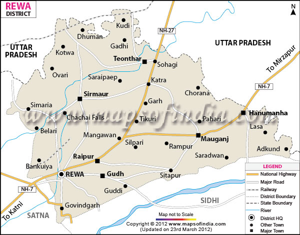
| *Rewa District Map highlights the National Highways, Major Roads, District Headquarter, etc in Rewa. | Disclaimer |
Rewa is one of the important districts of Madhya Pradesh
and located between 24?18' to 25?12' north latitudes and 81?2' to 82?18' east longitude.
The district headquarters is at Rewa town, which has a total population of 15,54,987 and an area of 6240 square kilometers.
Rewa has a great potential as a tourist hub with its historical reminiscences and forest resources. Some of the must visit places are Deorkothar, Govindgarh, Bandhavgarh and Sirmaur.
Last Updated on : February 19, 2026
The district headquarters is at Rewa town, which has a total population of 15,54,987 and an area of 6240 square kilometers.
Rewa has a great potential as a tourist hub with its historical reminiscences and forest resources. Some of the must visit places are Deorkothar, Govindgarh, Bandhavgarh and Sirmaur.
| Facts of Rewa District | |
|---|---|
| State | Madhya Pradesh |
| District | Rewa |
| District HQ | Rewa |
| Population (2011) | 2378458 |
| Growth | 17.63% |
| Sex Ratio | 893 |
| Literacy | 76.46 |
| Area (km2) | 6314 |
| Density (/km2) | 374 |
| Tehsils | Huzur, Raipur Karchuliyan, Mauganj, Hanumana, Gurh, Teonthar, Sirmour, Mangawa, Semariya, Jawa, Naigarhi |
| Lok Sabha Constituencies | Rewa |
| Assembly Constituencies | Sirmour, Semariya, Teonthar, Mauganj, Deotalab, Mangawan (SC), Rewa, Gurh |
| Languages | Hindi, Agariya, Bagheli, Bharia |
| Rivers | Tamas, Beehar, Mahana, Balen |
| Lat-Long | 24.756808,81.626816 |
| Travel Destinations | Rani Talab Temple, Govindgarh, Pili Kothi, Rewa Fort, Raipur Karchulian, Royal Museum, Govindgarh Palace, Baghael Museum, Deorkothar, Bansagar Dam, Ranipur Sanctuary, Chirahula Mandir, Ramsagar Mandir, Sai Mandir etc. |
| Government Colleges/Universities | Govt College (Devtalab), Govt Shahid Kedarnath College (Mauganj), Govt College (Raipurkarchul), Govt Thakur Ranmat Singh College, Govt Madhavrao Sadashivrao Golvalkar College, Govt Law College, Govt College (Semariya), Govt College (Gurh), Govt College (Naigarhi), Govt PG Science College, Govt Girls PG College, Govt Venkat Sanskrit College, Govt Swami Vivekanand College (Teonthar), Govt College (Mangawan), Awadhesh Pratap Singh University etc. |
Last Updated on : February 19, 2026