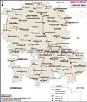
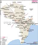
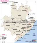
Andhra Pradesh Railway Map
Andhra Pradesh is situated on the India's southeastern coast and is the fourth largest state of India by area and the fifth largest by population. Andhra Pradesh has a total area of 275,045 sq km and comprises of 23 districts which are well connected by Indian railways. The Andhra Pradesh railway map shows the various stations, routes and places of importance accurately and will be helpful in guiding the travelers to their destination. There are various trains that reach the cities of Andhra Pradesh from all over the country.
The overall span of the railways network is 5,046 km. The state has an extensive line of railway network and boast of around 237 man railway stations, along with many railway junctions. Some important railway stations in Andhra Pradesh are: Adoni, Chittoor, Hyderabad Deccan, Nalgonda, Naupada Junction, Nizamabad, Nellore, Renigunta Junction, Secunderabad Junction, Tenali Junction, Tirupati, Vijayawada Junction, Warangal, etc.