






About
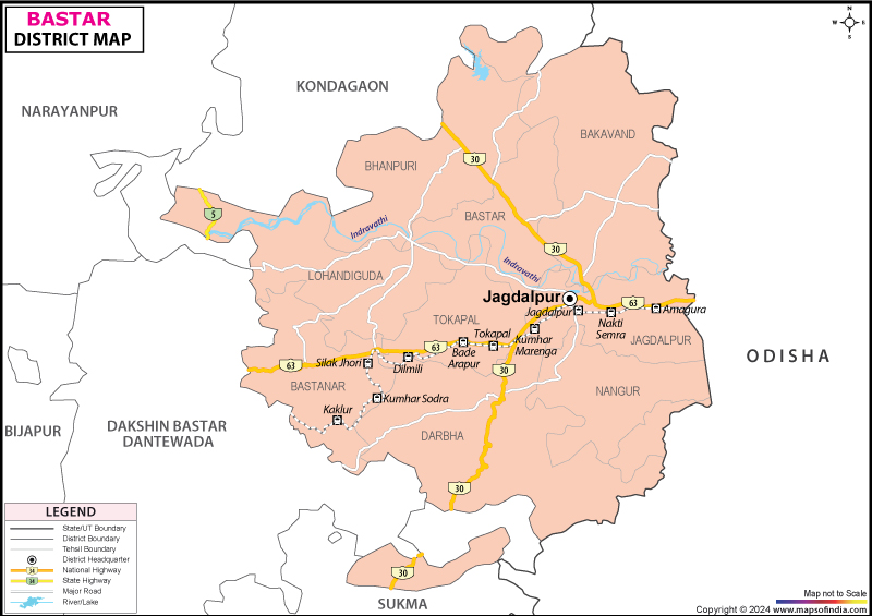
Under the cover of emerald sal trees, where the earth pours out deep iron red; the Indravati River carries with its old churn, old secrets; there's a realm wrapped in myth. Welcome to Bastar. Located in southern India's belly, this legendary land is more than just an administrative region. Move your finger over a detailed Bastar district map and you will find a district that is bordered by Kondagaon, Dantewada, Sukma and Bijapur, with Odisha to the east. It is driven by the pulsating heart of Jagdalpur and acts as its administrative hub.
What name of Bastar arouses the thoughts of? It's a name that reverberates across epic tales from centuries ago and tribal folklore. Until a modern day division of lines and boundaries was laid on the Bastar district map, this was a land that had reverent significance: Dandakaranya or the land of forest earth on which Lord Rama walked, and deeply associated with the Ramayana. Bastar today gives expression to the eco-cultural majesty, as it is famous all over the world due to its roaring falls, underground limestone caves, and the Dhokra handicraft of bell–metal medallions, as well as an indescribable tribal spirit that transcends time.
History & Culture
Step through the door of time, not just rustled in the dusty archives; Bastar's history sings of the rustling leaves and thump of the heavy maddal drum. This forest space was a part of the territory of the glorious Nala dynasty in ancient times and under the influence of the Kakatiya rulers in the fourteenth century. The Bastar kingdom is traditionally associated with Annam Dev, who is said to have established the kingdom around 1324 AD. If we view the ancient Bastar district map, we will see how these medieval sovereigns carved out a kingdom where kings ruled with a Hindu style of kingship while having a deep tribal indigenuity within the structure of indigenous kingship.
The Bhumkal Rebellion of 1910 was one of the bloodiest and most courageous episodes and was a turning point. The brave tribal leader Gunda Dhur led the protest against the British Raj's oppressive forest policies from the forest. The seeds of chilli, red earth, and branches of mangoes were quietly exchanged from village to village, a call to arms across every ridge, revealed on a Bastar district map. Although the rebellion was ruthlessly put down by the British, it stamped a mark of indomitable tribal spirit and self-respect on Bastar.
In terms of culture, Bastar is a colourful tapestry, made up primarily of major indigenous communities, namely the Gond, Maria, Muria, Bhatra and Halba. The world famous festival of Bastar Dussehra is an incredible festival that lasts for an astounding seventy-five days in the Indian subcontinent. Now, don't burn Ravana effigies here; it's a magnificent cosmic tribute to Goddess Danteshwari where all the remotest hamlets on Bastar's district map showed up. Wooden chariots, made by tribal people, roll down the streets of Jagdalpur with thousands of enthusiastic devotees in their midst and a display of undying devotion.
All of the environments here are filled with artistic creativity. The famous Dhokra art, which dates back over four thousand years from the Indus Valley Civilisation (IVC) region, uses the traditional lost-wax technique to create large bronze figures of horses, deities and dancers of brass/bell metal. The region also demonstrates other architectural aspects, including terracotta pottery and work of wrought iron Loha Shilp and wooden carvings which help to articulate the artistic firings of the region. Haats flourish every weekend and the aroma of Mahua and the sound of bamboo flutes bathe them.
Economy
In order to understand how life unfolds within these thick forests, one needs to look at the three-dimensional economic structure of Bastar. An economic Bastar district map reveals the importance of territory and the impact it has on economic activity in both rural and urban settings.
Government Sector
Socio-economic stability rests on the firm base of administrative framework and government initiatives in the district. Rural development is actively promoted by the state agencies, including forest conservation programmes, tribal welfare schemes and infrastructure development. District Mineral Foundation is given a major responsibility to redirect resources from mineral wealth to healthcare, education, clean water initiatives, and more in their area. The members who are involved in gathering Non-Timber Forest Products are provided with proper market rates for their collected produce through government procurement of NTFPs like Tendu leaves, Sal seeds, wild honey and Mahua flowers. In addition, ongoing public agricultural extension services train farmers in modern, sustainable paddy cultivation and the processing of millets.
Public Sector
Mining and heavy industrial companies have a strong public presence in and around the area. The wider Bastar region is connected to the iron-ore resources of the Bailadila range in neighbouring Dantewada district; therefore, it is an important steel and mineral supply chain across the country. Both large public sector undertakings and extensive railway logistics systems operate the huge freight traffic throughout the area shown on the Bastar district map in this region. The formal urban economy is supported by good job opportunities and infrastructure linkages available from the nationalised banks, regional rural banks and state electricity boards.
Services Sector
The quick urbanisation of Jagdalpur has given a big boost to the growth sector of services. Expansion of banking, telecommunications, hotel, and educational services is rapid. Indeed, as the development of eco-tourism has grown, hospitality services have become particularly important as thousands of local youths work with boutique jungle resorts, homestays and guided tours of the heritage. Beyond traditional farming, many activities such as retail trading, transport logistics, and craft cooperatives are important ways of earning a livelihood with Dhokra metalwork and terracotta exports.
Tourism
Bastar has been coloured by the vagaries of Nature's palette with feverish intensity and an overwhelmingly magnificent array of colours. Ravines and deep escarpments conceal cascading streams, and hidden under the rock layers lie the recesses of caves, which produce beautiful, sparkling geometries over millions of years. Anyone who reads the Bastar district map will fail to miss the irresistible path to paradise.
The first among all its wonders is the majestic and humbling Chitrakote Waterfalls. The Indravati River winds around almost ninety feet down the sheer cliffs of sandstone, many of which are used to make horseshoe bends, thus making it the Niagara of India. With the rain in the monsoon season, the sound is horrid; intoxicating spray reflects like a mist dragon, creating wild rainbows across the gorge.
Another magical locality is Kanger Valley National Park, a richly diverse biosphere. It is a woodland paradise with Tirathgarh Waterfalls right under its nose, with the Kanger River falling into white ribbons over stepped rockfalls.
Culture seekers should visit the Jagdalpur Palace, which is a remarkable architectural construction of that time and the sacred Danteshwari Temple. Lovers of nature can relax and unwind at the sprawling Dalpat Sagar Lake, an artificial lake that has been around for four hundred years and has serene island gardens and viewable sunset pictures.
Demographics
So folks are behind the sweeping landscape, which provides Bastar's soul. Other demographic studies and Census data provide a clear snapshot of the human features that are incorporated into the defined ‘borders' of a Bastar district map.
According to the population statistics in Bastar, the total population is around 834,375 people. One of the salient features of this population is that it is heavily tribal in nature, with about 70% of the total population being involved in the Scheduled Tribes population.
The district has made sustained gains in literacy scores in response to targeted efforts in the schools. The overall literacy rate is around 53.15%, of which men's literacy rate is around 63.02% and women's around 43.49%. However, the literacy rates are much higher in urban areas, such as Jagdalpur, than in the remote forest areas.
The linguistic variety here is very richly musical. While Hindi is one of the official languages of administration, the local variants, including Halbi, continue to be the main language spoken by Bastar natives and are tightly knit together with tribes on a Bastar district map. Gondi is the language spoken at home by the Gond tribes, while the Bhatri tribes speak a distinct Indo-Aryan dialect, Bhatri and an ancient Dravidian tongue, Dhurwa.
Administration
It's an efficient administration that's necessary with rugged topography and dense forest cover in the terrain. The civil administration is headed by the District Collector and the Magistrate at the headquarters in Jagdalpur. On closer examination of an administrative Bastar district map, Bastar is seen divided into various administrative divisions in order to bring governance to the grassroots level.
The district consists of 7 Tehsils such as Jagdalpur, Bastanar, Bastar, Bakawand, Lohandiguda, Tokapal and Darbha. These tehsils are subdivided into revenue sub-divisions and community development blocks to make the delivery of welfare services easier.
All these administrative regions in Bastar district have approximately 595 revenue villages. In the entire Bastar district map, panchayati raj governs by traditional tribal councils and elected Gram Panchayats help to preserve existing traditions and practices, bridging differences in the villages and ensuring effective management of local resources. Bastar maintains a formal administrative structure while simultaneously accounting for its unique socio-geographical context.
FAQs
Q.1: What is Bastar's population?
Around 834,375 people live in Bastar district.
Q.2: What language is spoken?
Hindi is official; Halbi and Gondi are native.
Q.3: What is Bastar famous for?
Chitrakote Waterfalls, Dussehra, and Dhokra craft.
Q.4: How many tehsils exist?
Bastar district has seven tehsils.
Q.5: Which river forms Chitrakote?
The Indravati River.
Q.6: How many villages exist?
Over 595 revenue villages.
Q.7: Which national park is here?
Kanger Valley National Park.
Last Updated on : August 24, 2026
