






About
Surguja is one of the districts of the northern region of the state of Chhattisgarh and the administrative center of the region is Ambikapur. The name Surguja is close to the region's princely history as the headquarters of the once powerful Surguja State, one of the largest princely states of the Chhattisgarh region under the British rule and now the district is the cultural and administrative hub of the Surguja Division which is the gateway to northern Chhattisgarh.
The district is best known for its peculiar and distinctive formations known as “pat”, elevated tablelands above the forest dotted countryside that give the district a hill-station-like climate in parts. It is mainly a tribal population, and its identity is so deeply tied to its mythology that it is believed that Lord Rama spent his years of exile through this area. Surguja is one of the oldest districts of the Chhattisgarh region, and was established in 2012 when the districts of Surajpur and Balrampur were split off from Surguja to form new districts, leaving the present small and tribal dominated district.
History & Culture
Ancient and mythological roots: In the local tradition it is believed that Lord Rama visited the Surguja region during his fourteen years of exile (Vanwas). Apart from this, some areas of the district are dedicated to the heroes of the Ramayana like Ramgarh, Sita-Bhengra and Laxmangarh. The Sita-Bhengra and Jogimara caves, thought to be from the Mauryan era, have the earliest known inscriptions in the area and have been associated with the poet Kalidasa according to folklore.
Princely and colonial era: Princely Surguja was under the rule of the kings of the Raksel Rajput clan who were believed to have ruled Palamu (now in Jharkhand) earlier and later came to rule here. Amar Singh became a king in 1820 and was crowned Maharaja in 1826. Raghunath Sharan Singh Deo was the Maharaja of Ambikapur in 1882 and he is credited as introducing modern institutions in Ambikapur such as a medical store, a post office, a court, a jail and a school.
Surguja was re-organisation in Madhya Pradesh after Independence in 1951 and was established as one of the districts of the newly formed state of Chhattisgarh in 2000 and again split into neighbouring Surajpur and Balrampur districts in 2012.
Culture: Most of the district's population is tribal and its social and cultural life shows a high degree of indigenous values and traditions in addition to the general religious life of Hinduism. Hindi is widely used, and the local languages, Sadri/Surgujiha, and tribal languages such as Kurukh (Oraon), are also widely used. The district also hosts a number of festivals, tribal art and community fairs around the temples like Mahamaya Temple. The town of Mainpat, where Tibetan refugees have been living for a long time, is also a Buddhist cultural addition to the district, with its monasteries and traditional woollen-craft industry.
Economy
The economy in Surguja is predominantly rural and agrarian with work for the government sector, mining activity and a rising service economy. Ambikapur is the headquarters of different divisions and districts and it has a large number of government offices like revenue, health, education and rural development departments. Government employment (district administration, panchayati raj institutions, teaching and healthcare services) is one of the big sources of formal jobs.
Mineral Resources: The region of Surguja was once the part of one district and has a vast amount of mineral resources, including coal, bauxite and limestone resources, which have historically attracted public sector and para-statal investment in mining and power related infrastructure. The district is home to public sector undertakings and related contracting activity, which create jobs and stimulate ancillary economic activity in and around the district.
The town Ambikapur is the main commercial and service center of the entire Surguja division with trading, transport, banking, healthcare and education services for the district as well as the neighboring areas. Handicrafts and other activities like the woollen/Kalin (carpet) trade of Tibetan people who settled in Mainpat add more diversity to the local economy.
Agriculture continues to be the main livelihood activity of most of the people in the district with paddy as the leading crop and forest based livelihoods (minor forest produce collection) having a major significance for people of tribal community in the district.
Tourism
The tourism scene in Surguja district is more colourful and rich and consists of mythology, ancient heritage, natural beauty and living tribal culture which makes this district one of the more unique locations in northern Chhattisgarh. The main attraction of religious tourism in the district is Mahamaya Temple in Ambikapur, an ancient temple dedicated to the presiding deity of the region which is visited by pilgrims throughout the year from all over the state. Equally important is the fact that the temple town is also a centre of Hindu worship with many lesser shrines and mazars complementing the presence of the temple.
Mainpat is the ultimate destination for those who want to experience a different climate and scenery, making it a top choice among Surguja's tourist attractions. This high plateau is also known as the "Shimla of Chhattisgarh" owing to the cool climate, grasslands rolling through it, and pine dotted landscapes, which are completely at variance with the rest of the state. Tibetan Buddhist monasteries, prayer flags and small-scale industries making traditional woollen carpets called Kalin also make this area of central India a distinctive cultural landscape seldom seen elsewhere, with the presence of the longstanding Tibetan refugee settlement. Tiger Point Waterfall is a scenic waterfall in the Mainpat plateaus, a popular spot for visitors seeking relief from the sweltering summer heat, while Chendra Waterfall is a weekend favourite among local families and visitors for its picnic grounds.
Surguja also has a lot to offer to those interested in history and mythology. The Sita-Bhengra and Jogimara Caves are ancient rock-cut caves believed to contain some of the earliest known inscriptions in India and local tradition strongly associates them with the Ramayana, with the legend that Lord Rama, Sita and Lakshmana passed through this region during the fourteen years of their exile. This mythical association also prevails with the nearby places like Ramgarh considered as one of the oldest historical importance in the district lying along the Ambikapur-Bilaspur road & Laxmangarh about few kms away where Lakshmana is said to have stayed. To the east, the Kailash Caves near Sabarbar, about 60 kilometres from Ambikapur, are another significant rock cut site in the district.
Water-based activities complete the district's attractions. A year-round natural hot spring, Taat Pani is thought to have medicinal qualities and is still visited by people who want relief from its ailments; near Sedam is Sedam Waterfall, surrounded by hills on the Ambikapur-Raigarh road, which offers scenic views and a modest Shiva temple hosting a great fair at Shivratri. Districts like this are rich in natural beauty and are a popular destination for nature enthusiasts who enjoy exploring the rugged landscape of the District through the dramatic rocky gorge of Rakasganda along the Hasdeo river.
Pilgrimage tourism has continued with such places as Kudargarh where a local deity was said to reside, with a large number of devotees visiting the temple; the ancient temple complex of Satmahala; the Shivpur Shiva Temple, where deities are worshipped during the Shivratri festival and the Vasant Panchami festival, and the Semarsot Durga Temple. Together, these sites embody the multi-layered nature of Surguja – its identity as a pilgrimage circuit, a hill retreat and an archaeological trail – and attracted more than 4.5 lakh domestic tourist visits in 2022 alone, helping to steadily carve out a place for itself in the travel itineraries of visitors seeking spiritual experiences and alternative natural exploration.
Demographics
According to the census of 2011, Surguja district is one of the moderately populated districts of Chhattisgarh with a total population of 23,59,886 . The district is predominantly rural in nature and is spread over an area of 146.6 persons per sq. km with majority of the population residing in villages and not Ambikapur town which is the only major urban center. The sex ratio is one of the more balanced ratios in the state, at 991 females to 1,000 males, and a reflection of the relatively stable social structures in the tribal communities of the state.
Though lower than the state average, the overall literacy rate of 61.16% is a sign of improvement over the last few decades and indicates the continued development of school infrastructure in the more distant tehsils. The language is Hindi which is used as the main medium of administration and day to day communication; while regional Sadri language (also known as Surgujiha) is used in households and local markets. The district is also linguistically diverse with the majority of the tribal languages, particularly the Kurukh language used by the Oraon community, being in active use. All of these markers reflect a young population which is primarily rural and culturally varied, with their social structure still largely influenced by their strong sense of tribal identity.
Administration
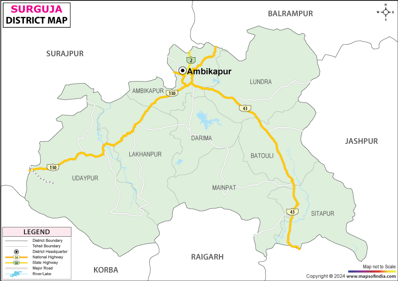
Surguja district consists of seven tehsils (Ambigkapur, Lakhanpur, Udaipur, Lundra, Batauli, Sitapur and Mainpat) for administrative and revenue purposes. Besides being a tehsil, Ambikapur is also the district headquarter and its broader area that of entire Surguja Division is the administrative nerve centre of a large district surrounding Ambikapur. The tehsils are also divided into gram panchayats, the smallest units of local self-governance within the Panchayati Raj system, that look after the development, welfare programmes and civic amenities of the villages. There are around 399 gram panchayats in the district, which are distributed unevenly in the tehsils as per the population and geographical spread, Ambikapur have about 86, Lundra about 70, Lakhanpur about 69, Udaipur about 53, Sitapur about 42, Batauli approximately 40 and Mainpat approximately 39 gram panchayats respectively.
These panchayats in turn, look after several hundred villages spread across the hilly and forested landscape of the district. Considering the rural and tribal base of the district, this layered structure (district, tehsil and gram panchayat) ensures that governance and development programmes are able to reach even Surguja's most remote and thinly populated pockets.
| Facts of Surguja District | |
|---|---|
| Official Name | Surguja |
| Location | Chhattisgarh |
| Area (km2) | 5732 |
| Population | 2,359,886 |
| Language | Surgujia |
FAQs
1. What is the district famous for?
The district is famous for its association with Ramayana, the hill station of Mainpat, the old temples and its huge tribal population.
2. What is the number of villages in Surguja district?
There are 439 village panchayats in the district.
3. How many people live in Surguja district?
The population of the district is 23,59,886 as per the 2011 Census.
4. What is the Capital of Surguja district?
Ambikapur is the capital along with being the headquarters of Surguja Division.
5. Which four states border the district?
Uttar Pradesh, Jharkhand, Odisha and Madhya Pradesh.
6. What is the literacy rate of the Surguja district?
60.01% is the literacy percentage as per the 2011 Census.
7. What is the primary economic activity of people in this area?
Agriculture and livelihoods of many tribal communities that rely on forests.
Last Updated on : August 24, 2026
