|
|||||||||||

| |||||||||||
|
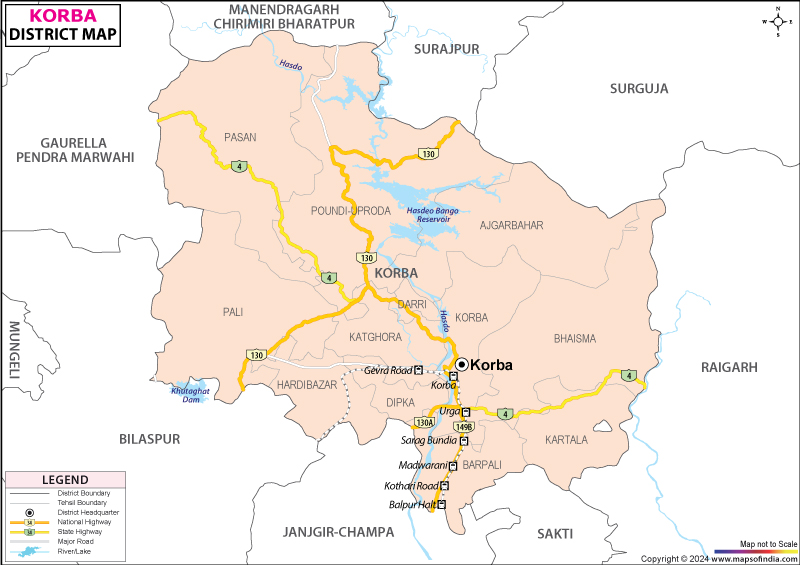
| *Map showing the National Highway, Major roads, other Roads, District Headquarter, Town, etc in the Korba District, Chhattisgarh | Disclaimer |
Korba District, the Industrial hub and power capital of Chhattisgarh was accorded the status of a full-fledged revenue district on 25th May 1998. Covering an area of 7,14,544 hectares and located at an altitude of 304.8 m above sea level Korba District stretching between latitude 22' 01'' to 230'01" and longitude 82' 08" to 83' 09", is enclosed by Korea, Surguja, Bilaspur and Janjgir districts.
The Hasdeo and Ahiran River primarily drains Korba District. Lush virgin forests cover the region, the opulent variety of flora including the:
With its headquarters in Korba City, the district is divided into Korba, Katghora, Kartala, Pali tehsils and Korba, Kartala, Katghora, Pali, Podi Uproda blocks. Naturally endowed with mineral resources like limestone, fireclay, etc it all possesses all the key ingredients required for thermal power generation. The Thermal Power Plants (KSTPS, BCPP, CSEB East, CSEB West) together generates 3650 MW of electricity. Transport and communication is also well developed in this industrial district.
The 2001 Census has recorded a population size of 10,11,823 with 964 males per 1000 females and a commendable literacy rate of 61.7%. The populace is dominated by the Pahari Korwa tribe while the Gond, Raj Gond, Kawar, Bhaiyana, Binjwar, Dhanuhar etc. Satnami, Ganda and Panka are the significant scheduled tribes. Conversant in the local Chattisgarhi dialect, the tribals lead colorful lives. The principal Adivasi dance forms include the Ravat Nacha, Karma Nacha and Suva Nacha.
The tribals mainly depend on agriculture for their subsistence. Korba District, the Industrial hub of Chattisgarh is renown for its black diamond and Kosa silk industry. Endowed with mineral deposit it has a widespread inustrial area spread over 100 acres with several inustrites and ancilliary units. The major industries include:
Korba abounds in natural beauty. The panoramic beauty of Chaiturgarh hills housing the majestic forts of the illustrious Pratidewa I and the pristine Mahisansur Mardini temples are worth visiting. Besides the industrial units also attract droves of tourists. Tourists also drop by to participate in the tribal festivities of Dev Uthni, Pola, Cherchera, Karma, Hareli etc and gain an insight to their cultural legacy.
Korba District lays emphasis on a comprehensive education system. The Indira Soochana Yojana is responsible for the widespread proliferation of education in the District. Bestowed with several good schools, colleges, polytechnic and other industrial training institutes the district offers quality education focusing on the student's overall development . Some of the district's premier academic institutes include Govt. P.G College, Korba, Mini Mata Girls College, Korba and Kamala Nehru P.G College, Korba.
Korba District, an amalgam of primitive tribal culture, resplendent natural beauty and urban industrial enterprise is worth a fruitful visit.
Last Updated on : February 19, 2026
The Hasdeo and Ahiran River primarily drains Korba District. Lush virgin forests cover the region, the opulent variety of flora including the:
- Sal
- Dhaora
- Kardhai
- Saliha
- Char
- Dhobin
- Tendu
- Amla
- Lendia
- Gunja
- Mahua
- Bija
- Kusum
- Bhelwa
- Jamun
- Harra
- Bahera
- Saja
With its headquarters in Korba City, the district is divided into Korba, Katghora, Kartala, Pali tehsils and Korba, Kartala, Katghora, Pali, Podi Uproda blocks. Naturally endowed with mineral resources like limestone, fireclay, etc it all possesses all the key ingredients required for thermal power generation. The Thermal Power Plants (KSTPS, BCPP, CSEB East, CSEB West) together generates 3650 MW of electricity. Transport and communication is also well developed in this industrial district.
The 2001 Census has recorded a population size of 10,11,823 with 964 males per 1000 females and a commendable literacy rate of 61.7%. The populace is dominated by the Pahari Korwa tribe while the Gond, Raj Gond, Kawar, Bhaiyana, Binjwar, Dhanuhar etc. Satnami, Ganda and Panka are the significant scheduled tribes. Conversant in the local Chattisgarhi dialect, the tribals lead colorful lives. The principal Adivasi dance forms include the Ravat Nacha, Karma Nacha and Suva Nacha.
The tribals mainly depend on agriculture for their subsistence. Korba District, the Industrial hub of Chattisgarh is renown for its black diamond and Kosa silk industry. Endowed with mineral deposit it has a widespread inustrial area spread over 100 acres with several inustrites and ancilliary units. The major industries include:
- Bharat Aluminum Company Limited (BALCO)
- Korba Super Thermal Power Station (KSTPS)
- South Eastern Coalfields Limited (SECL)
- Chhattisgarh State Electricty Board (CSEB)
- Indo-Burma Petroleum Limited (IBP), Gopalpur
- Indo-Burma Petroleum Limited (IBP), Kushmunda
- Indo Gulf Industries, Gobarghora
- Hasdeo Thermal Power Corporation.
Korba abounds in natural beauty. The panoramic beauty of Chaiturgarh hills housing the majestic forts of the illustrious Pratidewa I and the pristine Mahisansur Mardini temples are worth visiting. Besides the industrial units also attract droves of tourists. Tourists also drop by to participate in the tribal festivities of Dev Uthni, Pola, Cherchera, Karma, Hareli etc and gain an insight to their cultural legacy.
Korba District lays emphasis on a comprehensive education system. The Indira Soochana Yojana is responsible for the widespread proliferation of education in the District. Bestowed with several good schools, colleges, polytechnic and other industrial training institutes the district offers quality education focusing on the student's overall development . Some of the district's premier academic institutes include Govt. P.G College, Korba, Mini Mata Girls College, Korba and Kamala Nehru P.G College, Korba.
Korba District, an amalgam of primitive tribal culture, resplendent natural beauty and urban industrial enterprise is worth a fruitful visit.
Last Updated on : February 19, 2026