|
||||||||||
| ||||||||||
|





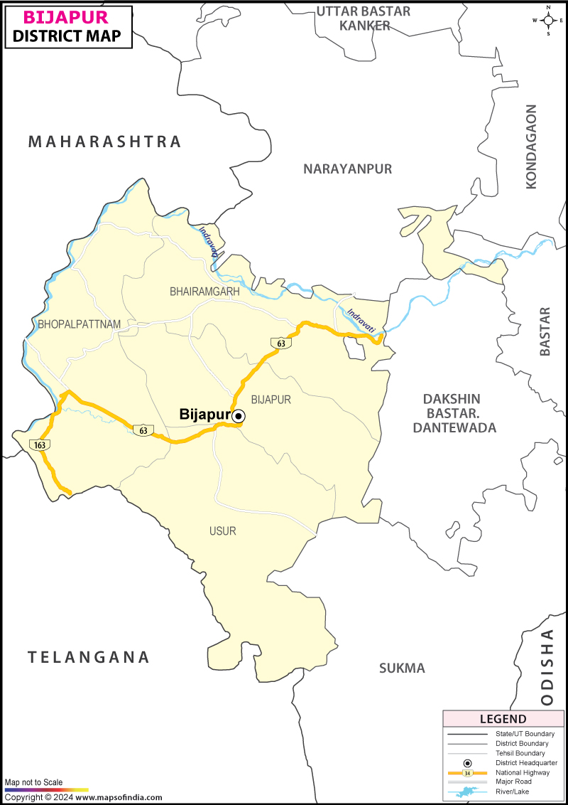
| *The Map showing the National Highway, Major roads, other Roads, District Headquarter, Town, etc in the Bijapur District, Chhattisgarh |
About
The district of Bijapur is an actual outlier on the map of India, not in terms of its achievements, but because of the vastness of its wilderness, and how recently it has started to turn to the outside world. Located in the southernmost corner of Chhattisgarh, it borders two other Indian states, Telangana and Maharashtra, making it unique among the Indian districts. It has a predominantly dense sal forest and hill country terrain broken through by the river Indravati, which not only forms the northern boundary of the district but has long been of great spiritual importance to the tribal people who inhabit this land.
But the most striking element of Bijapur is its recent past. This was one of the most troubled districts of the Red Corridor in India where for decades a raft of forests was effectively uninhabitable for outsiders because of the Naxalite-Maoist uprising. It's a process that's just started in the past few years, though, and it's evident in some subtle, but significant, ways: a waterfall now open to visitors; a new road constructed in a space where there was none before; and local youth organizing committees to lead visitors to the property instead of preventing them from visiting at all.
This is unlike the majority of districts profiled in a typical travel or administrative guide – it is not a century-old established tourist destination, or an industrial or agricultural powerhouse. It's, instead, a district whose narrative is still unfolding, whose same forests that were once the site of conflict and isolation are now being perceived as a natural beauty and a tribal cultural treasure—the sort of place that's becoming something new, right before your eyes.
History & Culture
The administrative history of Bijapur is also closely linked to that of undivided Bastar, one of India's most iconic princely states, and which was merged with Kanker in 1948 to form a district of Madhya Pradesh. The Bijapur district as it is known now got its more precise administrative origin from when it was made a separate administrative unit in 1907, but later came under the jurisdiction of Dantewada district. In May 2007, the Bhopalpattanam and Bijapur tehsils were transferred from Dantewada district and Bhairamgarh and Usoor districts were also transferred, after which the district of Bijapur was re-established as the southernmost district of the state.
In terms of culture, Bijapur is predominantly tribal, with the Scheduled Tribes population making up almost 80% of the district's population with the main community being the Gond, considered one of the oldest continuously surviving indigenous groups in the world. The district was linguistically diverse, with Gondi being spoken by about 63%, Telugu by nearly 17% and Halbi by nearly 8% of the residents, which is also the reason for the district being a cross-border region of Chhattisgarh, Telangana and Maharashtra. Despite the historical record of Hinduism as the dominant religion in the region, however, tribal deities, forest spirits and community-based shrines called Devgudis continue to play a central role in the religious life of this region, and sometimes even take precedence. The village markets (haats) as they are called are still important social and economic hubs where forest hamlets in the surrounding area bring their produce, forest products and handicrafts.
Economy
The economy has not yet become sufficiently diversified in Bijapur, being largely affected by forest cover, tribal population and decades of insurgency-related disruption, until recently.
The collectorate and other administrative buildings of the government sector have been given more importance to extend basic governance and infrastructure and welfare schemes in Bijapur, a relatively young and security-conscious district, to the remote forest villages. The district's recent development has been focused on road-building and connectivity projects, particularly those led by the government.
Public Sector: The forest cover is dense in the district and has a modest forestry and non-timber forest produce economy with tendu leaf collection, mahua and minor NTFP as contributing supplement to income of tribal households. Public and private investment has also been attracted by mining interests, especially those associated with the mineral-rich hill tracts of the district, but development to date has been hindered by security concerns.
Services Economy: Bijapur's services economy, which is still very small, was confined to small local markets in the town of Bijapur and other block headquarters for decades. A more recent development, however, is that now that security conditions have been improved in the district, places such as Nambi Waterfall have started to draw tourists, and local youth members have been organized into committees, responsible for guiding visitors, running small businesses and managing the logistics of visitors, thereby creating a source of income for the villages which had virtually no economic activity in recent years. The vast majority of the population of the district is still dependent on agriculture, mostly on paddy farming, as well as on forest-based livelihoods.
Tourism
The tourism scene of Bijapur has been virtually non-existent due to security issues, but is now undergoing a real and closely monitored transformation.
The neighboring area is now stabilized and Nambi Waterfall, about 700 feet high, has become a district highlight, attracting visitors who have been previously discouraged by the unorganized environment due to the lack of proper management. Nambi has now become the pride and joy of a local youth committee that takes charge of the guided tours and food stalls and also lays out basic infrastructure for tourists.
Indravati National Park is the only tiger park in the state of Chhattisgarh, stretching across the northern part of the district bordering the state of Maharashtra about 1258 square kilometres and has one of the last remaining wild water buffalo populations; however the area in the park is difficult to access.
Bhairamgarh Wildlife Sanctuary (BWS), located in the district, is a forest sanctuary with scenic beauty and wildlife species like chital deer, which can be spotted in its grasslands and forest areas.
Pamed and Kutru Wildlife Sanctuaries: other protected forests in the district, adding to Bijapur's significant contribution in terms of Chhattisgarh's wilderness and biodiversity cover.
Indravati River flows through the district and eventually merges with the Godavari and is in local tradition a symbol of faith and devotion to the people of the broader Bastar area.
For the longest time Bijapur was closed to outsiders and its forests and waterfalls were only known to security forces and local villagers but not tourists. That is changing slowly and erratically now with more guests being able to enter Nambi for the first time thanks to better roads and security. Even though this early trend shows promise of continuing and extending to the other natural sites of the district, which are still largely yet to be explored it has been noted by both officials and visiting travellers that basic tourist infrastructure (e.g., homestay and canteen, as well as ongoing security escorts) will be important to sustaining and expanding this.
Demographics
According to the Census of 2011 Bijapur district has a population of 255230 and out of this 128663 are males and 126567 are females resulting in a sex ratio of 984 females per 1000 males and the district's literacy rate is among the lowest in India at 40.86%, with the male literacy at 50.46% and the female literacy rate at only 31.11% that highlights the poor education opportunities in the district over the years after decades of geographic isolation and insurgency-related instability. The vast majority of district's residents lived in remote, forest-dependent rural settlements throughout the four tehsils of the district, while only around 11.6% of residents were found in urban areas.
Nearly 80% of the inhabitants of Bijapur belonged to the Scheduled Tribes and the highest concentration was in this district, the Gond community being the main backbone of the population and culture of the district.
Combined, these numbers depict a people that has been grappling with developmental pressures some of the most severe in India, but with early, real evidence of change. However, as security improves in the district and government spending on roads, schools and connectivity increases, there is hope that the district's literacy, poverty and access indicators — some of the toughest figures recorded in the last census — can start to improve meaningfully in the next round of the decennial population count in Bijapur.
Administration
The district is divided into 4 Tehsils, which are also the development blocks in Bijapur, Bhairamgarh, Bhopalpatnam and Usoor respectively. The district includes about 565 villages and 3 towns distributed through the predominantly forested area of the district. Coordination and police presence are given special importance here because it is a traditional hub of insurgency, and the security apparatus is embedded in the district's development and governance program.
The district collector's office, located in Bijapur town, is responsible for revenue administration, coordination of security activities and implementation of tribal welfare and infrastructure projects, in addition to having local panchayat representatives to bring governance to the remote forest villages of the district.
The administration of Bijapur still exists and is one of the most secure in India owing directly to the decades of experience it has gained with the Naxalite insurgency. The collector's office here is also constantly involved in helping to coordinate with paramilitary and police personnel posted across the district to ensure that basic administrative procedures such as building a road, conducting a census, organising a panchayat election or even distributing welfare benefits in a remote forest village is undertaken with security clearance and, in many cases, armed escort.
This is not an accidental but a structural aspect of a close relationship between civil and security administration, as seen in the design of new government schemes here, which is often to have multiple aims, including development as well as consolidation of government presence in areas under the control or contestation of Maoist groups. However, with improvements in security over recent years, this dynamic has slowly been changing, and administrators now have more time to pursue more traditional government concerns such as road access, access to schools and, increasingly, the early-tourism infrastructure that is now building up around Nambi Waterfall and other locations. Nonetheless, Bijapur's government remains somewhat circumspect and coordinated with the security forces, a necessity that is not shared by other districts of Chhattisgarh, even those in Bastar division.
| Facts of Bijapur District | |
|---|---|
| Official Name | Bijapur |
| Location | Chhattisgarh |
| Area (km2) | 8529 |
| Population | 2,55,230 |
| Language | Gondi, Telugu and Halbi |
FAQs
Q.1: How many villages are there in Bijapur district?
There are 699 villages in the district.
Q.2: How many people live in the district of Bijapur?
According to the Census 2011 the population of the district is 2,55,230.
Q.3: What is the district famous for?
The dense forests and tribal Gond culture, the Indravati National Park and Tiger Reserve and the recently become popular Nambi Waterfall are the most well-known attractions of Bijapur.
Q.4: What is the literacy percentage of the district?
According to the 2011 Census, the district literacy rate was 40.86%, which was one of the lowest amongst all the districts in India at the time.
Q.5: Which languages are spoken in Bijapur district?
Gondi is the most widely spoken language in the district, followed by Telugu and Halbi because of the geographical location of this district at the tri-junction of Chhattisgarh, Telangana and Maharashtra.
Q.6: What is the number of tehsils in Bijapur district?
The district has 4 tehsils: Bijapur, Bhairamgarh, Bhopalpatnam and Usoor.
Q.7: In which year was the Bijapur district created?
The Bijapur district was carved out from the erstwhile Dantewada district on 11 May 2007.
Q8: What is the administrative structure of the district?
The district is managed through 4 tehsils which are also development blocks and are co-ordinated by the district collector's office located in Bijapur town and where the civil administration and security operations are closely integrated.
Last Updated on : September 15, 2026
