|
||||||||||
| ||||||||||
|





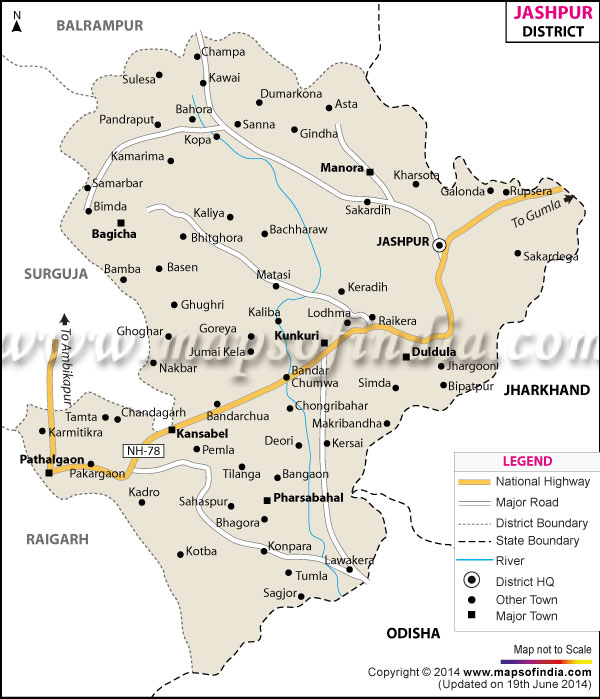
| *Map showing the National Highway, Major roads, other Roads, District Headquarter, Town, etc in the Jashpur District, Chhattisgarh |
About
Jashpur is situated high in the vast Chota Nagpur plateau, with its emerald ridges dancing through the mists of the morning. Ancient Waterfalls thunder down hidden, forgotten ravines. The majestic eastern gateway of Chhattisgarh is renowned for its stunning waterfalls and hills, earning it the nickname "Land of Waterfalls and Hills".
Blessed by their geographical location- Jharkhand in the East and Odisha in the South- visitors are drawn to this extraordinary sanctuary and are provided with a wild, undulating canvas. The countryside features thick sal forests, sprawling tea farms and raised plateaus (pats). Here, nature is unspoiled and dominates all aspects of life. The scenic north, dominated by the well-known high point Sanna and the Upper Ghats. is characterised by fresh, chilly climatic conditions similar to those of hill stations. In the meantime, the sun-kissed southern plains stretch out softly and fruitfully as agrarian basins.
Here in this undisturbed area, nature takes over all aspects of life. The dramatic northern section with the famous Upper Ghat is characterized with its fresh, cold weather which is similar to hill stations/weather. While the exciting sun-illuminated Southern plains spread out beautifully into agricultural basins.
History & Culture
This emerald wilderness passes the time at a more methodical pace. The erstwhile royal state used to be ruled by the Dom dynasty before Jashpur accepted the paramountcy of the Bhonsles of Nagpur and was later brought under Surguja for administrative purposes.
Traces of the past remain in the moss-covered stone monuments and tribal songs. In the landscape, sacred groves are still hidden. One can see on an old Jashpur district map how much rugged geography has preserved its unique way of life for the native tribes by tracing their ancestral routes.
Culture in this elevated wonderland is also alive and kicking and breathes through the village square. It is mostly inhabited by the Oraon, Birhor, Nagesia, and Gond communities, where seasonal festivals bring about the thunderous beat of the traditional mandar drum.
The colourful festival of Sarhul, the festival of flowering sal trees, fills the entire land with the tune of music and synchronised dancing. In the event of Karma Puja, young women and men perform the dances in harmonious circles around the branch altars to bring about agricultural harvest and cosmic harmony.
Centuries-old remedies using herbs are passed on verbally from generation to generation, as are intricate traditional crafts and vibrant indigenous wall art called “Sohrai.” This pursues a continuous pact between these native stewards and their beloved ancestral land.
Economy
However, unmistakable in the economic pulse of the area are the many different layers of its natural abundance, the ability of its traditional farming practices and the state-guided change through various initiatives. A detailed Jashpur district map accentuates an economy that has literally been formed from the thick forests and agricultural communities.
Government Sector
The government sector is a key lifeline for socioeconomic development and employment across the region. There are targeted state initiatives that take a holistic approach to forest conservation, rural infrastructure development and welfare programmes for tribal sections, which are actively sustaining livelihoods in rural areas. The systematic procurement and collection of low-value forest crops, such as tendu leaves, mahua flowers and honey and beeswax by government initiatives, have empowered the indigenous people.
Public Sector
Widespread enterprise in the public sector and effective administrative machinery is the underpinning of local economic resilience. Protected forestry departments provide access to the forest and managed roads connect to the pass, allowing vast forest reserves to reach remote hamlets with healthcare services, basic primary education and modern energy projects. In an active promotion of their organic valued crops, the state-sponsored agricultural credit cooperatives are helping the farmers of the region sell their products such as native aromatic rice varieties and cashew nuts.
Services Sector
The service sector grows along with the growth rate in digital infrastructure and transport systems, which is a widespread enterprise sector in all the urban places, such as in Jashpur Nagar and Kunkuri. The commercial trade side, banks, transport and logistics companies and telecommunication networks have seen spectacular growth. With the rise of ecotourism, local eco-guides, homestays facilitated by rural communities and community-led tourism initiatives are gaining momentum and are now visibly taking tourists to local secrets that've been noted on each Jashpur district map.
From the tropical lowland rice fields to the experimental high plateau farms. The vast majority of the population is involved in these agrarian activities which employ and sustain them directly.
Tourism
A trip into this other-than-normal place is a trip to a world of natural miracles, cascading rivers and intense spiritual holiness. Upon opening up a detailed Jashpur district map, you will discover a stunning array of jaw-dropping landscapes, cascading waterfalls and ancient monuments waiting to be explored.
Kotebira Eb River: Kotebira forms a magnificent natural gorge, situated where the mighty Eb River violently plunges its force through narrow and clashing rocks. Surrounded by stories of local lore and the old country folklore of tribes throughout ages past that descend on this site, the waters are forever churning and the roar of the Eb River is prominent even as the gentle rain of nature photographs joins in.
Nestled in the deep, private shade of clusters of sal trees, the raging white falls of Danpuri cruelly drop their mammoth heads down tiered faces of stone, leaving a trilling array of bubbling water and refreshing woods during relief.
The crystal-clear, emerald coloured natural plunge pool of nature that is surrounded on all sides by towering jungle trees is the reason why, revered all around, Rajpuri is such an ideal destination for nature lovers. Ranidah's rugged, dramatic fall into the rear of a deep, rocky basin heralds a peaceful and pensive refuge awash in towering cliffs.
Sanna Plateau & Tea Garden is renowned, the unbroken swaths of cool uplands offering endless rolling hills and a misty horizon, the vivid emerald green of the thrive upon the experimental tea estates which cover the land in the hills.
Following a Jashpur district map is an exciting adventure in locating these majestic natural sanctuaries.
Demographics
With a view to its demographic makeup, this highland sanctuary is interesting in the sense that it provides a look into indigenous population density, linguistic diversity, and rates of educational attainment.
The demographic distribution is better illustrated on the Jashpur district map as seen and is a clear example of the distribution of various communities over the thoroughfare of the upper highlands and the lower plains. The population at the time of the official census for the entire region comes to about 851,669.
Overall reading rate has continued to rise steadily to almost 67.92 percent which is a commendable educational change that was created by continuous drawing up of state education schemes and grassroots educational programmes. Male literacy has reached around 77.32% per cent across urban centres and isolated tribal hamlets within the region, and female literacy continues to steadily rise, hovering around 58.61 per cent.
Linguistically, it has some diversity and the most prevalent languages are Sadri (lingua franca of the tribal populace), Kurukh (language of the indigenous population of Oraon in the area), Chhattisgarhi and Hindi (standard). English and Odia are also widely understood and used in the main commercial nodes due to inter-state trade, education and administrative interaction along the borders.
Administration
To govern and administer a realm of difficult, rocky land, lofty plateaus and lonely forest hamlets requires a tightly organised and multi-layered system of administration.
A detailed official administrative Jashpur district map clearly reveals the successful public governance, civil administration, law enforcement, revenue collection and developmental outreach from the Central municipal offices of Jashpur Nagar extending through the most distant settlements in the wilderness. The Collector and District Magistrate is the administrative head of the region who oversees the collection of revenue, district civil defence, social welfare plan implementation, and public order affairs throughout the district.
The district is divided into five revenue subdivisions and nine tehsils, which largely facilitate efficient governance, equitable public service delivery and streamlined monitoring of revenue. The key administrative tehsils which administer this huge area are Jashpur, Kunkuri, Pathalgaon, Bagicha, Duldula, Farsabahar, Kansabel, Manora and Sanna.
These are various local or rural villages that cover an area of around 766 populated villages and hundreds of traditional tribal hamlets or tolas across the diverse sub-districts and are governed seamlessly by civil oversight and governance. This vast network of rural settlements is at the heart of networked, decentralised village governments (Panchayati Raj); Gram Panchayats directly lead local public works, infrastructure to distribute drinking water, primary education and health in the villages.
Other than revenue collection, public security is guaranteed by strategically sited police stations and outposts located in rural areas that ensure peace in large tracts of heavy forest and trackless mountainsides. Forestry management goes hand-in-hand with civil governance, and dedicated forest type divisions work diligently to ensure the safety of wildlife, prevent illegal logging, and ensure that tribal community land rights are respected as per the provisions of the Forest Rights Act.
This three-dimensional administrative network allows government resources (e.g., escalation, infrastructure investment, agricultural subsidy, etc.) to flow directly to each and every community in the most accurate manner, to be recorded on an official Jashpur district map.
FAQs
Q.1: What is the district headquarters?
Jashpur Nagar, marked on a Jashpur district map.
Q.2: What is the total population?
The region has 851,669 inhabitants.
Q.3: How many villages are there?
766, as can be seen on a Jashpur district map.
Q.4: What is the literacy rate?
It is 67.92 percent.
Q.5: Which famous church is highlighted on the Jashpur district map?
It is the Kunkuri Cathedral.
Q.6: What crops are grown?
Tea and strawberries.
Q.7: Why its referred to as "Land of Waterfalls and Hills"?
For its enchanting hills and waterfalls .
Last Updated on : September 15, 2026
