|
|||||||||||

| |||||||||||
|
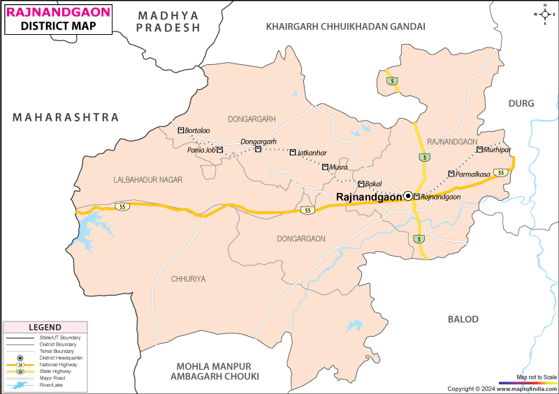
| *Map showing the National Highway, Major roads, other Roads, District Headquarter, Town, etc in the Rajnandgaon District, Chhattisgarh | Disclaimer |
The Rajnandgaon District is located in the centre of the Chhattisgarh state covering an area of 6396.28 sq. km. It was formed on 26th January in 1973, by separating from the Durg district. It was originally called Nandgram, but was again divided on 1st July 1998 and the new district of Kawardha was formed. The total population of the district is 12,83,224, consisting of 6,34,342 males and 6,48,882 female population.
The river Sheonath and its tributaries Kharkhara, Sonbarsa, Amner, Surhi, Karra, Murkati, Sankari, Fonk and Hanf flow through the district.
The three blocks of Rajnandgaon District are Mohla, Manpur and Chowki. The main tribes that inhabit the district are Gond, Kanwar, Halba and Baiga, who are nearly 25.16% of the total population of the district. These tribal areas are adjoining to Gadchiroli District of Maharastra and Baster District of Madhya Pradesh.
The major crop grown in the district of Rajnandgaon is Paddy. The region is rich in minerals like Limestone, Chinaclay, Quartzite, Quartz, Granite and White Clay. In the industrial sector the district Rajnandgaon is categorized as "B" or backward district. Few small and medium scale industries that play vital role in the economy of the district are Minwool rock fibres Ltd, Kamal solvent extraction (p) Ltd, MP Maharastra minerals Ltd, Bengal Nagpur cotton mills (a govt. of India undertaking), Vishwavishal engineering works (gas division), Raja Ram maize products, Mohad, Rukmini metals & Gasseous Ltd, and Simplex engineering & foundry works Ltd. The handloom industry of the district is flourishing at a rapid pace. It generated Rs.120 lakh of revenue in the year 1999-2000. These handloom co-operative societies in the district are engaged in the production of Bedsheet, Carpet, Towel, Sari and Dress material.
The main tourist as well as piligrimage centre of the district is Donargarh. It is famous for the temples of Maa Bambleshwari, situated on the hilltop of 1600 feet.
There are nine primary Health Centers in the Rajnandgaon district at Chhuikhadan, Dongargaon, Dongargarh, Churria, Manpur, Mohla, Chowki, Ghumka, Khairagarh and nearly seven Private Nursing Homes. Since Rajnandgaon is located on the southeastern railways between the Bombay-Howrah line, it is can be easily accessed by the rest of India. It is well connected by the road as the National Highway 6 passes through the town of Rajnandgaon. The nearest airport is about 80 km away at Mana of Raipur.
Some of the important educational institutions of Rajnandgaon district are:
Last Updated on : January 14, 2026
The river Sheonath and its tributaries Kharkhara, Sonbarsa, Amner, Surhi, Karra, Murkati, Sankari, Fonk and Hanf flow through the district.
The three blocks of Rajnandgaon District are Mohla, Manpur and Chowki. The main tribes that inhabit the district are Gond, Kanwar, Halba and Baiga, who are nearly 25.16% of the total population of the district. These tribal areas are adjoining to Gadchiroli District of Maharastra and Baster District of Madhya Pradesh.
The major crop grown in the district of Rajnandgaon is Paddy. The region is rich in minerals like Limestone, Chinaclay, Quartzite, Quartz, Granite and White Clay. In the industrial sector the district Rajnandgaon is categorized as "B" or backward district. Few small and medium scale industries that play vital role in the economy of the district are Minwool rock fibres Ltd, Kamal solvent extraction (p) Ltd, MP Maharastra minerals Ltd, Bengal Nagpur cotton mills (a govt. of India undertaking), Vishwavishal engineering works (gas division), Raja Ram maize products, Mohad, Rukmini metals & Gasseous Ltd, and Simplex engineering & foundry works Ltd. The handloom industry of the district is flourishing at a rapid pace. It generated Rs.120 lakh of revenue in the year 1999-2000. These handloom co-operative societies in the district are engaged in the production of Bedsheet, Carpet, Towel, Sari and Dress material.
The main tourist as well as piligrimage centre of the district is Donargarh. It is famous for the temples of Maa Bambleshwari, situated on the hilltop of 1600 feet.
There are nine primary Health Centers in the Rajnandgaon district at Chhuikhadan, Dongargaon, Dongargarh, Churria, Manpur, Mohla, Chowki, Ghumka, Khairagarh and nearly seven Private Nursing Homes. Since Rajnandgaon is located on the southeastern railways between the Bombay-Howrah line, it is can be easily accessed by the rest of India. It is well connected by the road as the National Highway 6 passes through the town of Rajnandgaon. The nearest airport is about 80 km away at Mana of Raipur.
Some of the important educational institutions of Rajnandgaon district are:
- Govt. Digvijay College
- Govt. Kamaladevi Women's College
- Govt. Science College
- Pandit Kishori Lal Shukla Govt. Law College
- Govt. Women's Politechnic
- Govt. Industrial Training Institute, at Rajnandgaon, Mohla and Dongargarh
- Govt. College, at Dongargarh, Chowki, Ramatola, Lalbhadur, Churria, Dongargaon, Manpur, Ghumka, Khairagarh, Chhuikhadan, and Gandai
Last Updated on : January 14, 2026