






About
Surajpur is a riveting green oasis nestled in the northern part of Chhattisgarh and is a vital geographical corner of the thick, dense heartland of Central India. Luminous symbolism, direct naming, hot weather, immigrant life and prosperity are all metaphorically mentioned in the name of Surajpur which means "City of the Sun”. Carved out of the old Surguja district on the first day of January 2012, this is a land of many cultures, one glorious amalgamation of pristine wilderness and ancient human history, symbolising the rich mix of tribal culture and modern aspirations.
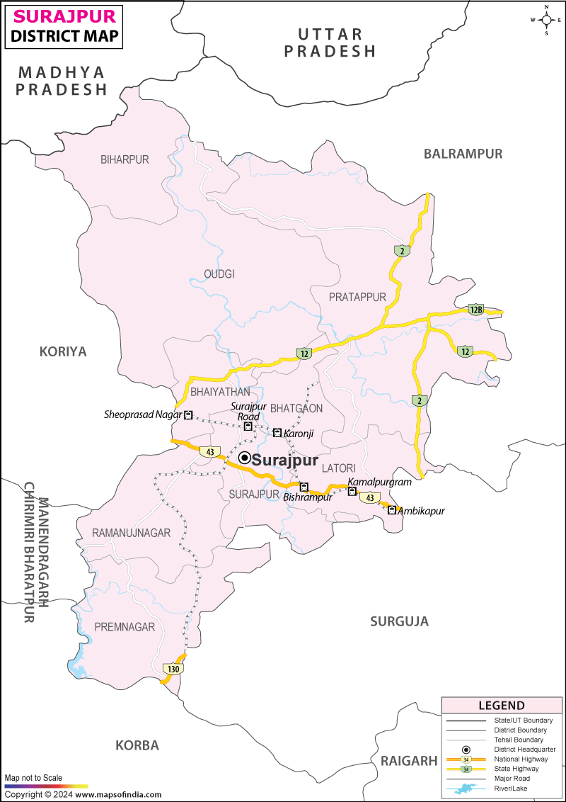
One simply needs to see the Surajpur district map to see why it is located in northern Chhattisgarh. Surajpur borders Surguja, Balrampur-Ramanujganj, Koriya and Korba districts of Chhattisgarh, while Singrauli district of Madhya Pradesh lies to its north. This surrounded territorial paradise with emerald canopy cover, rolling tablelands and winding rivers such as the Rihand instantly impresses your imagination.
The topography of the district, as can be seen from the Surajpur district map, is serene and environmentally blessed as a green heaven with ancient geological formations, plentiful coal and cascading waterfalls thundering through limestone gorges. It is a place of balance between the old and the new, the traditional and the modern, between the natural and the political, rhythmically bringing harmony in the positioning of each part of modern industrial development, making the district one of the essential landscapes of ecological balance, economic potential, and human resilience.
When taken as part of the detailed physical Surajpur district map, it becomes evident that the land gently slopes from rough and steep hillocks and the edges of the plateaus in the north to undulating fertile valleys of the rich alluvium in the central and southern parts of the district. This exceptional geographical diversity supports a remarkable diversity of life and also provides what is necessary for topography to be suitable for man's habitation, traditional farming, and sustainable infrastructure development.
History & Culture
In this district, there are old myths which echo the earth, folklore and royal pride. It was once part of a vast kingdom and had been under the control of different princely families who enjoyed centuries of self-sovereignty in these impenetrable forests for a long time. A Surajpur district map with trails of historical trade routes shows that these mighty hills were also a natural rampart and natural ghat and, at the same time, also nurtured unique tribal practices which remained unchanged and untouched by foreign influence.
Culturally, the land is rich in vitality and vibrancy, with traditional folk instruments and instruments playing rhythm during the seasonal festivals of the land, indicating the passage of time. The tribal people such as the Gond, Baiga, Korwa and Rajwar tribes have a reverent attitude towards nature, believing every tree, river and hillock was a living deity.
Whole settlements become stages of a frenzied jig, singing, and feasting in the festivals held during them, like Karma, Sarhul, and Cherchera. The youth dancers wear costumes during the festivities of Karma Puja, dancing around the sacred Karma on the Mandar drum while singing thanks for the gifts of nature and asking for peace for the community through dance. Every year, the rites of Mahamaya Mela and Shivratri at the historic temple grounds attract thousands of devotees, where tribal animism and Vedic worship converge to form the identity of the people. The oral history, preserved folk tales and colourful performing arts passed through the ages are a living link to the expansive past of the region, which still maintains an authentic cultural spirit that is little affected by commercialism today.
Economy
Concentrated within this area is a wonderful and very interesting mix of ancient agricultural tradition and enormous mineral deposits. The navigation through the Surajpur district map makes it possible to trace the most important agricultural regions along the fertile river base as well as the most important industrial cross-sectoral nodes in the district, which provide significant energy for the modernisation of the region.
Public administration in the Government complex, State welfare schemes, infrastructure expansion and farming support schemes constitute a significant employment base in this sector, which is still developing and promotes rural development and long-term economic sustainability. Local administrative offices, healthcare networks, public educational institutions, and rural development programs are continually creating jobs, and public funds are flowing directly into the rural economy.
Below the surface, however, is tremendous mineral wealth dominated by the presence of central energy companies (mainly South Eastern Coalfields Limited, Coal India's major subsidiary). Bishrampur and Bhatgaon coalfields are dotted with giant open-cast and underground coal mines which bring huge revenues, expansion of infrastructure and direct state employment to thousands of miners, engineers and industrial technicians.
The major roads on a Surajpur district map are also sites of rapid urban expansion, catering to a surging services industry which includes local markets, educational facilities, telecommunications, logistics centres, banking networks and much more. Surajpur town is a commercial hub which spreads agricultural produce, consumer goods and industrial equipment at a regional level.
Agriculture continues to be the lifeline of rural households as paddy, pulses, oilseeds and sugarcane cover the land while collection of non-timber forest produce, such as Mahua flowers, Sal seeds, Tendu leaves and wild honey provides sustainable livelihoods for the tribal households. With the stabilisation of irrigation projects based on river water, the farmer groups have also been empowered to grow multi-crops and cash crops with the help of the traditional methods of subsistence agriculture.
Tourism
The terrain holds a kitty full of beauty, sanctuaries, and wildlife. Using the Surajpur district map, one can follow the arterial routes and discover amazing natural and historical locations, showcasing the purity of the natural beauty of central India.
Devoted and with a deep history of faith, the Mahamaya Temple on Devipur welcomes many passersby during the auspicious homecoming festival of Navratri. The temple complex lies in an isolated site surrounded by natural beauty; the tranquillity and spiritual intensity are conveyed by the awe that the complex generates.
The Rakasganda Waterfall, a roaring, dramatic fall formed on the Rihand River, is a popular daytime or weekend visit for nature lovers, as it's filled with a misty world full of photos. In the heart of the city, the magnificent green areas such as Shiv Park and serene local lakes offer a peaceful evening getaway for all in the community, including over-tired tourists.
Demographics
The cultural fabric of the socio-demographic blueprint is rich and predominantly rural indigenous, with a gradually increasing urban population. Population density is closely linked to agricultural lands and the mining centres of the district, as observed from the Surajpur district map, presenting a harmonious distribution of demography.
According to the 2011 Census, Surajpur had a population of 789,043, comprising 398,381 males and 390,662 females. Most citizens live in scenic rural towns with deep social networks, community governance and familial traditions.
Overall, the region's literacy rate has been progressively rising over the last few decades; as per the census, it's around 60.95% and efforts are being made by the state to boost education, tribal welfare programmes, residential schools, and initiatives by grassroots rural groups to improve literacy among the young people. There are significant strides in bridging the historic gap between urban and rural educational facilities in various major tehsils, with increasing access to primary, secondary and higher education institutions.
Language diversity abounds on the land, and the territory is characterised by a rich tapestry of spoken languages. Surgujia is rich and expressive, being the main form of interaction in daily life, both at the markets, households and community events. Official communication, teaching and commerce are done in Hindi, and in the quiet forest hamlets, you can hear local spoken languages like Kurukh, Gondi, and many other native tribal languages, including centuries of oral histories. This multilingual setting is conducive to the development of a high level of intercultural awareness, and to the fruitful interaction between the ideas of today and those of yesterday.
Administration
It is an inefficient administration that can mean no effective governance, health, public distribution or infrastructure in this huge forested region. The Surajpur admin map layout shows a structured hierarchy, which is efficient in managing the development, law enforcement, revenue generation, and allocation of resources in the district.
The district collectorate is the top management level that pulls together all the sub-districts' routine work related to the state's welfare programs, rural development and multiple preparedness schedules for natural hazards. The district has six tehsils: Surajpur, Odagi, Bhaiyathan, Pratappur, Premnagar and Ramanujnagar, to facilitate civil administration. Each of the tehsils is supervised by tehsil administrative officers who carry out land administration, police & security, civic amenities and development activities.
Together, they manage 547 villages, in which, even in the most lonely spot identified on a Surajpur district map, the state's welfare policies are being implemented, rural healthcare networks are active, primary education takes place, and agricultural support infrastructure. The Panchayati Raj is established on a village basis, giving local tribal councils and village elders the power to make decisions at a local level on issues for the community's welfare, natural resource management and prioritisation of local development.
FAQs
Q.1: How many villages are in Surajpur?
There are 547 villages.
Q.2: What is the population of Surajpur?
The population is 789,043.
Q.3: What is Surajpur famous for?
It is famous for Kudargarh Temple, Tamor Pingla Sanctuary, and coal mining.
Q.4: What is Surajpur's literacy rate?
The overall literacy rate is 60.95%.
Q.5: What is the sex ratio in Surajpur?
It is 980 females per 1,000 males.
Q.6: State and formation date of Surajpur?
It is in Chhattisgarh, formed on 1 January 2012.
Q.7: Main languages spoken in Surajpur?
The main languages are Surgujia, Hindi, and Chhattisgarhi.
Last Updated on : September 15, 2026
