The Indian divine geography of the Twelve Jyotirlingas sounds like a faint echo of the Twelve Jyotirlingas in a field of lights in each of which man rises to the divine without losing some kind of physical contact with what is immortal, formless. The name Jyotirlinga is formed by a play on words: a combination of jyoti, meaning “radiance”, and linga, the iconic representation of Shiva, which thus forms a description of infinite light. It is remembered in ancient scriptures that there are only twelve that are most sacred of the initial sixty-four, all having their myths and architectural heritage and traditions that were many centuries old. To these shrines, pilgrims have traversed mountains and rivers and woods and seas, through the centuries, to kneel before them; and in their coming to the shrines lies no less devotion than in the shrines themselves.
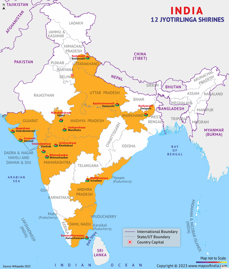
12 Jyotirlinga : Shiva Temples in India
| S.No. | Jyotirlinga | State | Location |
|---|---|---|---|
| 1 | Somnath | Gujarat | Prabhas Patan,Saurashtra |
| 2 | Mallikārjuna Swāmi | Andhra Pradesh | Srisailam |
| 3 | Mahakaleshwar | Madhya Pradesh | Ujjain |
| 4 | Omkareshwar | Madhya Pradesh | Omkareshwar |
| 5 | Kedarnath | Uttarakhand | Kedarnath |
| 6 | Bhimashankar | Maharashtra | Bhimashankar |
| 7 | Kashi Vishwanath Temple | Uttar Pradesh | Varanasi |
| 8 | Trimbakeshwar Shiva Temple | Maharashtra | Trimbakeshwar, near Nashik |
| 9 | Nageshvara Jyotirlinga | Gujarat | Dwarka |
| 10 | Vaidyanath Temple | Jharkhand | Deoghar |
| 11 | Rameshwar | Tamil Nadu | Rameswaram |
| 12 | Grishneshwar | Maharashtra | Near Ellora,Aurangabad |
Somnath
Somnath is actually not just a shrine but a record of survival located on the west coast of Gujarat, Prabhas Patan. Thought to be the earliest of the Jyotirlingas, the formation history credits the golden initial temple to the Moon demigod Soma, then silver, then wood, followed by the stone temple. The temple has a bloody history of being destroyed by Mahmud of Ghazni, among others, but every time they resurrected. Today, the 50 metre high shikhara in its splendour of a Chalukya style rises, and it has defied centuries of disturbances. It has a view of the Arabian Sea, where the water appears to go on forever; a metaphor of the infinite aspect of Shiva himself. Believers gather long before dawn to await the first rays of sunlight to fall upon the sanctum, and it is the replica of its very title, viz., the invisible (or the place of the invisible) to the moon, the Protector of the Moon.
MallikarjunaThe Mallikarjuna temple of Srisailam, lofty in the Nallamala Hills of Andhra Pradesh, is the unification of religio-romantic devotion with natural majesty. In this, we find Shiva being worshipped together with Shri Parvati, in her incarnation of Bhramaramba. Their descent into the hills to console their son Kartikeya, who had gone away weeping to these hills, is known through the lore. The temple is shielded with various wildlife-filled dense forests with a tall gopuram and finely engraved pillars. The Krishna river passes peacefully through below, festivals here involving a carnival of music, dancing and ritual to the celebration of bounty that reflects in the landscape.
MahakaleshwarThe Mahakaleshwar Jyotirlinga in the city of Ujjain, which is saturated with Vedic culture, has a spiritual as well as cosmic meaning. Here, the fact that it is the sole linga with a south orientation denotes the form of Shiva that overcomes death, and it is the ruling control of time. There is a famous Bhasma Aarti ceremony at 4 a.m. every day, which is performed and can not be compared with any other one, because sacred ash, the symbol of impermanence in life, is provided, and mantras are heard all over the stone halls. The streets around are filled with devotion, and in particular during the day when Maha Shivaratri is celebrated, the temple foreground is lit up with thousands of oil lamps, and a halo of the golden sanctity of the Kshipra flows around the temple.
OmkareshwarMandhata Island contains the Omkareshwar temple in the shape of a primordial syllable of ॐ in the centre of the Narmada River. The pilgrimage itself is incorporated into the island: a lot of people follow the divine sound circle around the island in their footsteps. The stone walls of the temple, which are both worn and determined, are the symbols of centuries of belief. There are legends of Shiva coming here to save the devas against the asuras, and hence, the Island is blessed by his eternal existence. There is the song of moving river water with the constant recital of Om Namah Shivaya floating in the sanctum.
KedarnathWithin the Uttarakhand region of the Himalayas, at 3,583 metres, far above the tree line, the Jyotirlinga of Kedarnath is one of the most mountaintop mind-blowing pilgrimage sites. It dates back to the Pandavas, who were in penance due to the war of Kurukshetra, and it was redeveloped by Adi Shankaracharya. It is a pilgrimage in itself to get to Kedarnath, a trek through alpine meadows, along gurgling streams and beneath some towering peaks. It is huge grey slabs of stone that have been used to construct the temple, which is set against the backdrop that feels and looks like snow powdered over the Kedarnath range. The deity is also transferred to Ukhimath during winter, when snow covers the area, so that there is never any loss of continuity in the worship.
BhimashankarThe Bhimashankar temple, located deep in the mist‑laden western ghats of Maharashtra, has rich biodiversity, which has granted it sanctuary status. Here, it is said, Shiva conquered the demon Tripurasura. One gets a calm atmosphere in the Nagara architecture of the temple and the graceful, as it were, uprising of the spire, such as seems almost to fuse with the moss-covered stones of the forest. Pilgrims frequently stop on the tracks to listen to the calling of the rare birds, which, in this case, the music of awakening is united with the music of the living forest.
Kashi VishwanathThe Kashi Vishwanath Jyotirlinga is immortalised in Varanasi, one of the oldest communities existing cities in the world. It lies on the banks of the river Ganga, and it is said that even living in this city gives one the guarantee of moksha or rebirth liberation. The temple has been demolished, as well newly constructed several times since, with the present temple built in the 18th century, by Queen Ahilyabai Holkar. In this case, the spiritual cannot be unseen in the day-to-day reality, as pilgrims get out of ritual bathing in the Ganga to give bows, and the temple bells play upon a beat that has barely been kept in human recall.
TrimbakeshwarTrimbakeshwar, which is part of the Brahmagiri mountains that are situated near Nashik, is the origin of the Godavari River. The feature unusual to it unusual is the three-faced linga, the symbol of unity of the creation, preservation, and destruction, depicting figures of Brahma, Vishnu, and Shiva together. It is one of the key places of Shraddha rituals, during which their ancestors are worshipped by their offspring on the banks of the sacred river. The mood is a kind of sorrowful devoutness, the voices of priests in the mist as it rises along the riverbank.
VaidyanathVaidyanath Jyotirlinga is deified as a healer of both body and soul in Deoghar, a place in Jharkhand. The most accepted myth associates it with Ravana, who, in devotion to Shiva, offered his heads to the deity one after the other. Shiva was impressed and breathed life back into him, and gave the linga the power to heal. The Kanwar Yatra is a pilgrimage that pilgrims, more so in the Shravan month, perform and carry the Ganga water over vast distances to pour it over the destroyer of sins, i.e. linga, a combination of faith and penance.
NageshwarNageshwar, in the vicinity of Dwarka in the state of Gujarat, is related to the protective nature of Shiva against evil, serpents and all those that are poisonous. On the outskirts of the temple, a massive 25-metre statue of Shiva can be seen in the distance, rearing over the salt-infused air of the coast. The shrine is a calmer interior contrast, however, with the low light and the smell of sandalwood taking the worshipper into a meditative state.
RameshwarmmaIn the island of Ramanathapuram in Tamil Nadu, the Ramanathaswamy temple is associated with the Ramayana. Lord Rama is known to have meditated to Shiva at this spot before making the bridge to Lanka. The temple is home to a 1,200-metre-long corridor that features more than 1,000 intricately carved pillars. Many pilgrims take a dip in the 22 theerthams (sacred tanks) within the temple premises before saying their prayers, said to wash both body and soul.
GrishneshwarJust near the Ellora Caves in Maharashtra lies the smallest of Jyotirlingas, but its abundance in art is commensurate in size. Built from red basalt, its walls have figures of scenes from Shaivite mythology. The temple is associated with the tale of a devoted lady named Kusuma, whose unrelenting worship brought Shiva in front of her. Its close vicinity to the UNESCO-recognised Ellora complex makes it a repository of spiritual and socio-cultural heritage.
Conclusion
The twelve Jyotirlingas are witnesses to a millennial faith that has joined the spiritual, cultural and geographic centre of India. Originally built on top of a Himalayan ridge or embraced by a sea breeze or secreted away in a forested hill, the story of every shrine includes some element of resilience, devotion and the eternal counterpoint of creation and dissolution that are a part of Lord Shiva. Once traversed, they are the soul of the country - the soul of its myths and memories, its art and architecture, its rivers and mountains - and therein you can find, in the totality of its many lights, a reminder that the divine things indeed are more plentiful and yet at times so imminently present. But the material and fanciful Jyotirlingas are not just locations, they are beacons on the spiritual journey of the inner pilgrimage to truth, peace and liberation.
FAQs
Q1: What is the significance of the 12 Jyotirlingas in Hinduism?
The twelve Jyotirlingas are considered the holiest abodes of Lord Shiva, each representing a manifestation of his infinite and formless light. Visiting them is believed to purify the soul and aid in attaining moksha, or liberation from the cycle of birth and death.
Q2: Is there a prescribed order for visiting the Jyotirlingas?
There is no mandatory scriptural sequence for visiting them. Many devotees plan routes based on geography, such as northern, southern, western, or central clusters — while some undertake the Dwadash Jyotirlinga Yatra, attempting to visit all twelve in their lifetime.
Q3: Which Jyotirlinga is situated at the highest altitude?
Kedarnath, in Uttarakhand’s Garhwal Himalayas, holds that distinction, standing at an elevation of approximately 3,583 metres. Due to harsh winters, it is open for worship only between late April or early May and early November.
Q4: Can women and men both perform rituals at all Jyotirlingas?
Yes, all Jyotirlingas welcome devotees of any gender to offer prayers and perform rituals, though certain temples may have local customs or specific timings for entry into the innermost sanctum.
- National Science Museums in India
- Jyotirlinga Shrines
- Geological Map of India
- Canals in India
- Major Lakes in India
- Heritage Map of India
- Pin Code Zones in India
- Per Capita Income of India
- Major Sea Ports
- Languages in India
- Climate map of India
- Parlimentary Constituencies in India
- Tourist Circuits in India
- Metallic Minerals in India
- Cold Desert Map
- Major Electricity Generator Plants
- Religions In India
- Major Earthquakes in India
- Major Hydro Power Plants
- Indian States and Union Territories
- Cabinet Ministers
- Map of Indian States and Union Territories Enlarged View
- Physiographic Map of India
- Religious Places in India
- Geographical Map of India
- Dams in India
- India Coal Reserves Map
- India Political Map Enlarged View
- India Satellite Map
- Topographic Map of India
- Population Map Of India
- Natural Hazard Map of India
- Tourist Map of India Enlarged View
- Tier I and Tier II Cities of India
- Cyclone Prone Areas in India
- Outline Map of India Enlarged View
- Wine Producing Regions in India
- Map of Major Airports in India
- Birth Rate in India
- Statehood Movements in India
Last Updated on : April 17, 2026