



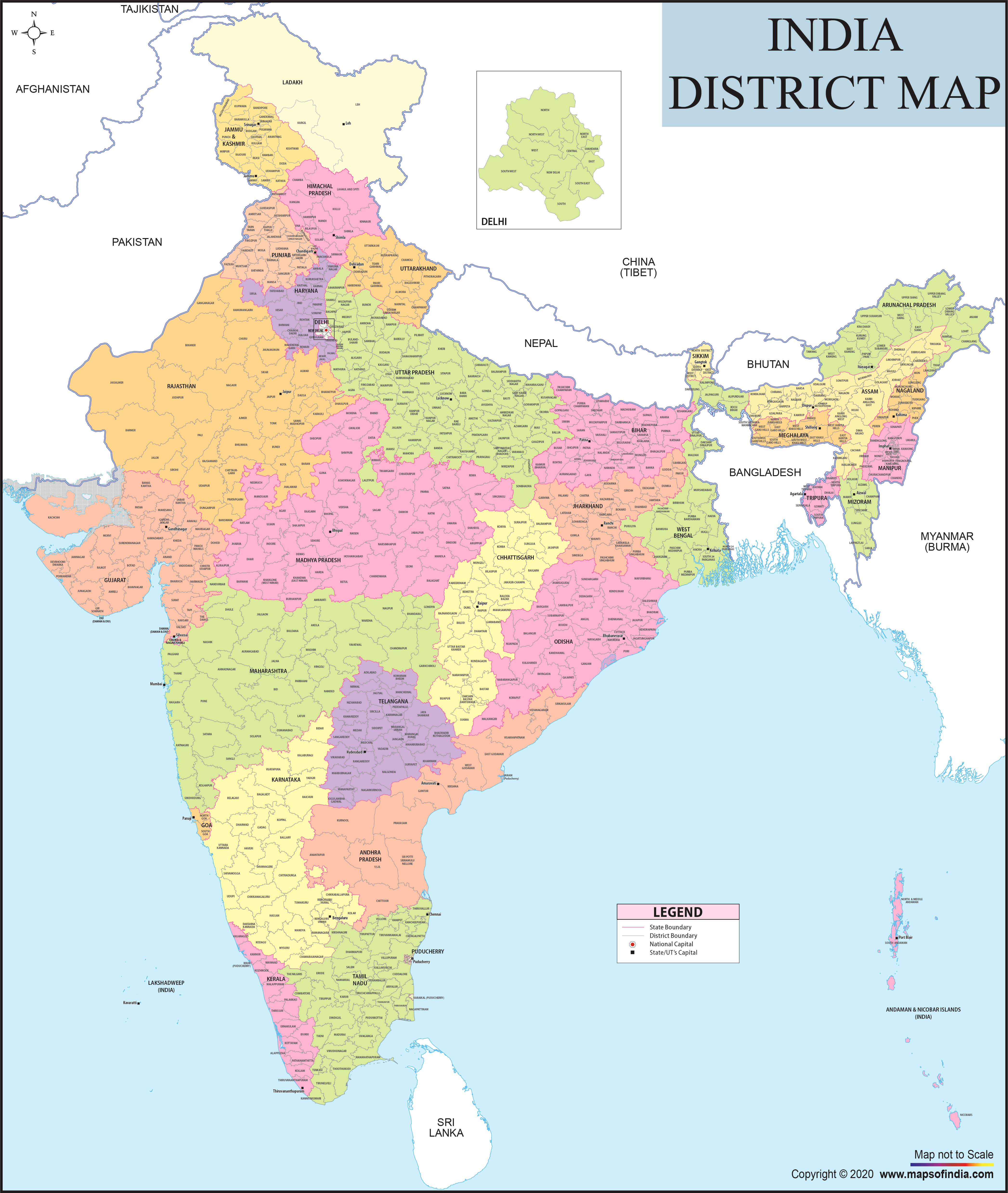



India is a vast country which is rich with diversity, including topography, culture, language and tradition. A large and diverse nation calls for a well-organized administrative system to manage the nation. The Districts of India Map is a map to outline the Internal divisions of India, comprising states and Union territories divided into fine Districts for efficient and effective Governance & Development.
One of the most essential administrative units of India would be the district. It is a bridge between the Government and the public by ensuring that policies and welfare schemes are implemented at the local level and that what is provided to the public by the government. India, being a vast nation, has more than 700 districts with varying features. The district map of India is a type of map that illustrates the geographical distribution, boundaries and location of districts.
What is a District Map of India?
A district map of India is a geographical representation with districts in India being shown with their boundaries and locations across various states and Union territories. A district map shows a detailed distribution of small administrative areas such as districts, whereas a state map only includes state boundaries.
These maps have been created to allow users the opportunity to get a quick glimpse of the locality in India. They illustrate the division of each state into several districts, each having its own administrative centre, geography and culture. A district map can be useful for regional planning, understanding of regional population distribution, transportation and economic activity.
Administrative Structure of Districts in India
Indian administrative system is a hierarchy. The country has two units at the highest level: States and the Union Territories. They are further divided into districts, which are further subdivided into smaller administrative areas like division, tehsil, taluk, block and village.
The districts have district-level local officials who are kept responsible for law and order, administration of government programmes, revenue system management, and coordinating development activities. The district administration has a significant influence on education, health, agriculture, infrastructure, and disaster management. To understand the administrative system better, the Districts of India Map is created and represents the distribution map of the districts.
Importance of the Districts of India Map
The India District map is very useful for students, scientists, tourists, business people, and people interested in the study of geography and the different districts of India. It presents a clear picture of the divisions of the country that extend beyond the state level.
District maps serve as a tool for teaching about Indian geography to students and help them to grasp the regional divisions. These maps are used for analysis of demographic patterns, economic activities and development trends. A traveller may plan a trip and travel within a district, viewing maps and exploring different areas, and a business can analyze district locations and opportunities for expansion and business.
The district-level information is also used by government agencies to help plan infrastructure projects, roll out welfare policies and to allocate resources based on the needs of the regions.
State-Wise Distribution of Districts in India
Districts are different in numbers from one state to another, based on the population, geographical size, administrative requirements and developmental needs of the state. For example, large states may have more districts to facilitate governance, and smaller states or Union Territories could have fewer administrative districts.
Districts in Uttar Pradesh, Maharashtra, Rajasthan and Madhya Pradesh are the most populous and have the highest area, and hence they are also at a large number. Districts of coastal states like Gujarat, Kerala, Tamil Nadu and Andhra Pradesh are the hubs of important activities like trade, fishing, tourism, and industries, etc.
Located in the northeast, the districts play a crucial role in the administrative control of the remote mountainous regions and in maintaining the unique cultural heritage of this region. A State-wise district map aids the viewer in exploring these differences and in comprehending the administrative diversity of India.
Features of an Interactive District Map of India
The interactive District Map allows for easy and digital access to the districts of India. Selecting a specific state, users can see information on the state districts, their boundaries, location, and state region.
Common characteristics of an interactive map of the district are:
- Detailed district boundaries
- State-wise district identification
- Conveniently move from one area to the other
- Geographical understanding of different areas
- District area and administrative areas information
Districts Reflecting India’s Diversity
All Indian regions have their own distinctive pattern derived from their history, geography, economics and culture. Some districts have a traditional, agricultural or natural resources-based focus, while other districts have area products, technologies, tourism or traditional craft character.
For example, certain districts are known for their historical monuments, while other districts are able to make significant contributions to manufacturing, agriculture and trade. The district map is a wonderful illustration of this incredible diversity in India, as the different regions are united to create the social and economic fabric of the nation.
Role of District Maps in Development Planning
Balanced growth of the districts is a precondition for balanced growth all over India. Each area has its own concerns and opportunities, so often development plans are individual according to the needs of the area.
A district map is used for identifying infrastructure, connectivity, healthcare, education and economic opportunity needs. It provides better geographical information to make decisions – geographical context and conditions.
District-level information can serve as an important tool for many applications, including rural development programmes, urban planning and policy-making and is essential for the country's development in the coming years.
Exploring India Through District Maps
The District map of India is an in-depth look at the territorial and administrative jurisdictions of the country. It connects people across state lines to explore the smaller geographies and drive change and growth in India.
These maps showcase the districts of a country in an explanatory and illustrative manner and help the student understand the administrative boundaries and learn about various districts, identify travel routes, research topics on the map, or learn the different features of each district.
List of Districts of India State Wise
| S.no | States and Union Territories in India | No. of Districts | Population |
|---|---|---|---|
| 1 | Andhra Pradesh | 28 | 49,386,799 |
| 2 | Arunachal Pradesh | 28 | 1,383,727 |
| 3 | Assam | 35 | 3,12,05,576 |
| 4 | Bihar | 38 | 10,40,99,452 |
| 5 | Chhattisgarh | 33 | 2,55,45,198 |
| 6 | Goa | 3 | 14,58,545 |
| 7 | Gujarat | 34 | 6,04,39,692 |
| 8 | Haryana | 22 | 2,53,51,462 |
| 9 | Himachal Pradesh | 12 | 68,64,602 |
| 10 | Jharkhand | 24 | 3,29,88,134 |
| 11 | Karnataka | 31 | 6,10,95,297 |
| 12 | Kerala | 14 | 3,34,06,061 |
| 13 | Madhya Pradesh | 55 | 7,26,26,809 |
| 14 | Maharashtra | 36 | 11,23,74,333 |
| 15 | Manipur | 16 | 28,55,794 |
| 16 | Meghalaya | 12 | 29,66,889 |
| 17 | Mizoram | 11 | 10,97,206 |
| 18 | Nagaland | 17 | 19,78,502 |
| 19 | Orissa | 30 | 4,19,74,218 |
| 20 | Punjab | 23 | 2,77,43,338 |
| 21 | Rajasthan | 41 | 6,85,48,437 |
| 22 | Sikkim | 6 | 6,10,577 |
| 23 | Tamil Nadu | 38 | 7,21,47,030 |
| 24 | Telangana | 33 | 35,193,978 |
| 25 | Tripura | 8 | 36,73,917 |
| 26 | Uttar Pradesh | 75 | 19,98,12,341 |
| 27 | Uttarakhand | 13 | 1,00,86,292 |
| 28 | West Bengal | 23 | 9,12,76,115 |
| 1 | Andaman and Nicobar | 3 | 380581 |
| 2 | Chandigarh | 1 | 10,55,450 |
| 3 | Dadra and Nagar Haveli and Daman and Diu | 3 | 585,764 |
| 4 | Lakshadweep | 1 | 64473 |
| 5 | National Capital Territory of Delhi | 13 | 1,67,87,941 |
| 6 | Pondicherry | 2 | 12,47,953 |
| 7 | Ladakh | 2 | 274,289 |
| 8 | Jammu and Kashmir | 20 | 12,267,013 |
FAQs
Q1: What is the Districts of India Map?
The Districts of India Map shows the administrative divisions of India, including district boundaries and locations across states and Union Territories.
Q2: How many districts are there in India?
India has more than 700 districts, and the number changes as new districts are created for better administration.
Q3: Why are districts important in India?
Districts help in local governance, implementation of government schemes, and delivery of public services.
Q4: What does a district map of India show?
It shows state-wise district boundaries, locations, and administrative divisions of different regions.
Q5: Which state has the most districts in India?
Large states like Uttar Pradesh have a high number of districts due to their population and geographical size.
Q6: How are districts different from states?
States are larger administrative units, while districts are smaller divisions within states or Union Territories.
Q7: Why is the Districts of India Map useful?
It helps students, travellers, researchers, and others understand India’s regional and administrative structure.
Last Updated on : June 18, 2026
