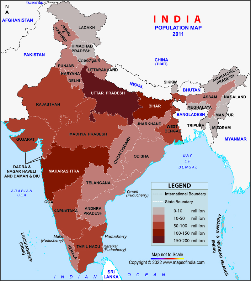
India is a fast growing developing nation as well as treading towards the path of being the youngest country of the world with an average age of 29. With a dynamic upsurge in the population since the past decades, India has become the second most populated country in the world. India is home to 1.324 billion people and is the largest democracy in the world. According to the Census report of 2011, there has been a remarkable increase in the population of India from 1.071 billions in 2001 to 1.247 billion in 2011 with a decadal growth of 17%.
The population density of India has inflated from 325 persons per square km in 2001 to 382 persons per square km in 2011, making Delhi, the capital city of India, the most densely populated Union Territory of the nation followed by Chandigarh. In the 12th Indian Census, the states of Uttar Pradesh, Maharashtra and Bihar are highly populated states of India. The demographic dimension of Uttar Pradesh, Maharashtra and Bihar were 199,281,477, 112,372,972 and 103,804,637 respectively in 2011. The State wise population of India saw a rampant rise from 2001 to 2011.
The population map of India has a prismatic variation. It ranges from 64,429 of Lakshadweep, 16,753,235 of Delhi, 27,704,236 of Punjab, 41,947,358 of Odisha, 103,804,637 of Bihar to 199,281,477 of Uttar Pradesh. An inflation in the population growth rate of the country leads to an upsurge in poverty and creates a disparity in the education-equity process. In the twenty first century the population growth rate of India saw a stark decline and the decadal growth rate was 17.64 as compared to 21.54 of 2001. The Indian Population Map is symptomatic of the varied degree to which the population of our developing nation is metamorphosing and provides significant information in terms of a nation's population density, decadal rate as well as growth rate. Maps aid the individuals with important information and the hues of the visuals leave an indelible impression on the minds of the viewer.
General Maps
- National Science Museums in India
- Jyotirlinga Shrines
- Geological Map of India
- Canals in India
- Major Lakes in India
- Heritage Map of India
- Pin Code Zones in India
- Per Capita Income of India
- Major Sea Ports
- Languages in India
- Climate map of India
- Parlimentary Constituencies in India
- Tourist Circuits in India
- Metallic Minerals in India
- Cold Desert Map
- Major Electricity Generator Plants
- Religions In India
- Major Earthquakes in India
- Major Hydro Power Plants
- Indian States and Union Territories
- Cabinet Ministers
- Map of Indian States and Union Territories Enlarged View
- Physiographic Map of India
- Religious Places in India
- Geographical Map of India
- Dams in India
- India Coal Reserves Map
- India Political Map Enlarged View
- India Satellite Map
- Topographic Map of India
- Population Map Of India
- Natural Hazard Map of India
- Tourist Map of India Enlarged View
- Tier I and Tier II Cities of India
- Cyclone Prone Areas in India
- Outline Map of India Enlarged View
- Wine Producing Regions in India
- Map of Major Airports in India
- Birth Rate in India
- Statehood Movements in India
Last Updated on January 14, 2026
