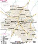
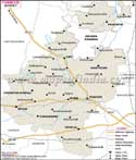
Haveri District, the focal point of Karnataka's art and culture covering an expanse of 4823 sq. km was carved out from Dharwad district.
Strategically located 335 km from the capital city of Bangalore, Haveri is enclosed between Dharwad district on the north, Gadag district on the northeast, Bellary district on the east, Davangere district on the south, Shimoga district on the southwest and by Uttar Kannada on the west and northwest, respectively.
Haveri District has a population of 1,439,116 as per the 2001 Census. The local residents reap crops and indulge in industrial enterprises and other allied ventures to earn their living. The district is also trying to exploit its gold and silver deposits in order to earn revenue.
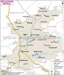
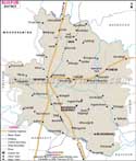
Haveri District's tourism industry is dependant on the majestic and revered shrines at
- Byadgi
- Ranibennur and
- Savanur, respectively.