Raichur District Map


District Map of Raichur

separator Click here for Customized Maps arrow custom map
District Map of Raichur Vijayapura Yadgir TELANGANA ANDHRA PRADESH Ballari Koppal Bagalkot
Print Email Save Buy Now 
*District Map of Raichur highlights national highway, major roads, railways, rivers, etc. Disclaimer


  Major Districts of Karnataka  
Bangalore District Map Belgaum District Map Gulbarga District Map Shimoga District Map
Bangalore District MapBelgaum District MapGulbarga District MapShimoga District Map
    
Tumkur District Map Bijapur District Map Dakshin Kannad District Map Mysore District Map
Tumkur District MapBijapur District MapDakshin Kannad District MapMysore District Map
  other districts of Karnataka  >>

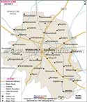
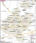
Raichur is situated in the eastern part of Karnataka. From the historical perspective, this district is very important.

It stretches from 15 degree 09 min-16 degree 34 min North latitude and 75 degree 46 min-77 degree 35 min East longitude. The total area of Raichur is 14,013 sq km. According to the census of 1961, the total population of Raichur is 1961 11,00,895.

Raichur is known for producing good quality rice. It has also received acclaim as producer of cotton and oil seeds.

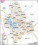
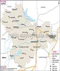
A tourist visiting Raichur should not miss the places like
  • Ranganatha Temple
  • Pampa Sarovara
  • Kamal Mahal
  • Huchchappayana Matha


Last Updated on : May 17, 2018


-->