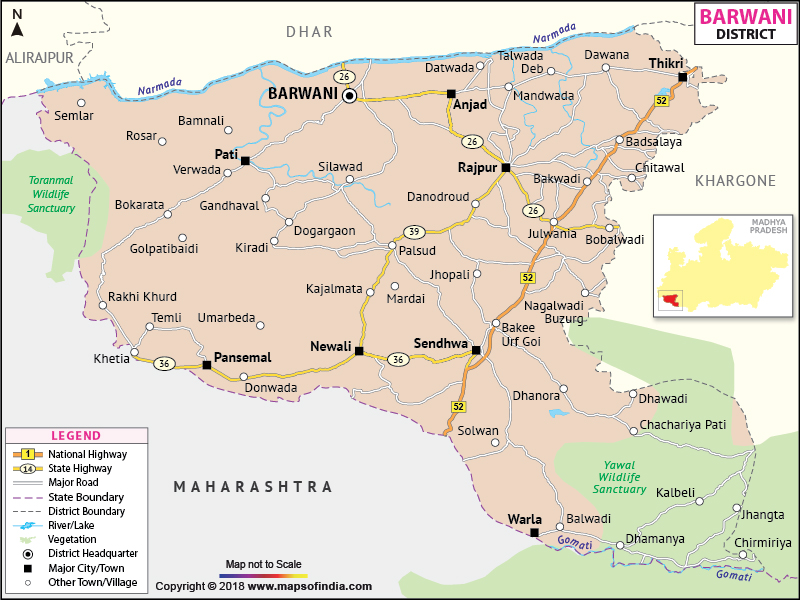
The district of Barwani is situated in the south western part of Madhya Pradesh
. The geographical location is 21? 37' to 22? 22' North latitude and 74? 27' to 75? 30' East longitude.
Barwani was formed in 1998 with an area of 3665 sq. km. The total population of the district as per the census of 2001 is 10,81,039. The number of male members is 547837 compared to 533202, the total number of females.
Barwani is noted as an important Jain pilgrimage center. The places a tourist should not miss are
Last Updated on : January 14, 2026
Barwani was formed in 1998 with an area of 3665 sq. km. The total population of the district as per the census of 2001 is 10,81,039. The number of male members is 547837 compared to 533202, the total number of females.
Barwani is noted as an important Jain pilgrimage center. The places a tourist should not miss are
- Veereshwar Mahadev Temple
- Nagari Mata Temple
- Bawangaja
- Bhawar Garh
| Facts of Barwani District | |
|---|---|
| State | Madhya Pradesh |
| District | Barwani |
| District HQ | Barwani |
| Population (2011) | 1385881 |
| Growth | 27.57% |
| Sex Ratio | 982 |
| Literacy | 49.08 |
| Area (km2) | 5432 |
| Density (/km2) | 256 |
| Tehsils | Barwani, Thikri, Rajpur, Sendhwa, Pansemal, Niwali, Anjad, Pati, Warla |
| Lok Sabha Constituencies | Khargone (ST) |
| Assembly Constituencies | Sendhwa (ST), Rajpur (ST), Pansemal (ST), Barwani (ST) |
| Languages | Bareli, Bareli Palya, Bhil, Bareli Pauri, Bhilali |
| Rivers | Narmada |
| Lat-Long | 21.841105,75.067978 |
| Travel Destinations | Bawangaja (Chool Giri), temple of Godess Beejasani, Jambu Gali Ganesh Mandir, Shree Savliya temple, Vaishno devi temple, Kalka mata temple, Mahalaxmi temple, Santoshi Mata Temple, Ram-Krishna Temple, Moti mata temple, Shani Temple, Sai Temple, Satyanarayan Temple, Bandhan Water Fall, Rajghat, Gwalbeda, Nagalwadi etc. |
| Government Colleges/Universities | Govt Degree College (Anjad), Govt Girls Degree College, Govt College (Pansemal), Govt PG College (Sendhawa), Shahid Bheema Nayak Govt PG College, Govt. Arts & Commerse College (Niwali), Govt Degree College (Rajpur) etc. |
Last Updated on : January 14, 2026
