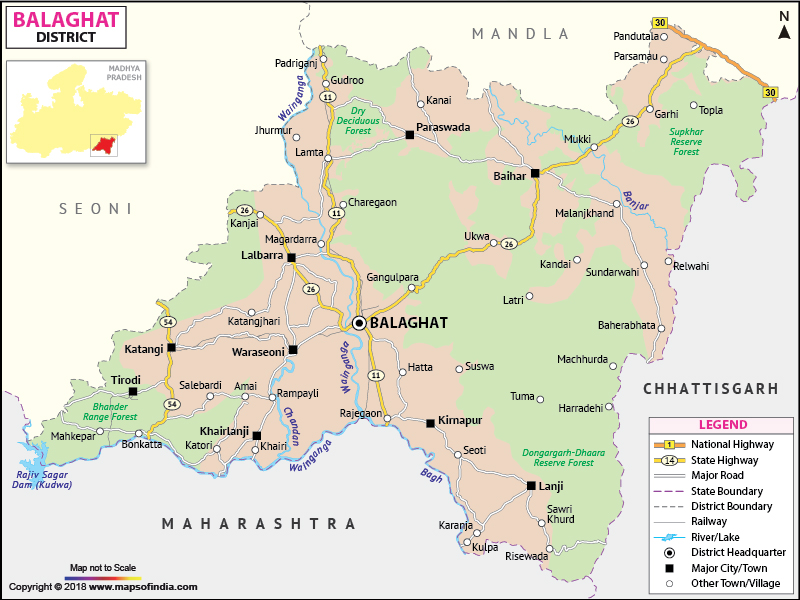
Balaghat is in the south eastern portion of the state of Madhya Pradesh. The district is situated within 21.19' to 22.24' North latitude and 79.31 to 81.3' East longitude.
The total area of Balaghat is 9245 sq. km. According to 2001 census is 14,97,968. Among the total population, the number of male is 6,82,260, where as the number of female is 6,83,610. The population density of Balaghat is 148 persons per sq km.
The important resource of Balaghat is its forest land. The district is also rich in mineral deposits like Manganese, Bauxite and Copper.
The places important for tourism are
LLast Updated on : January 14, 2026
The total area of Balaghat is 9245 sq. km. According to 2001 census is 14,97,968. Among the total population, the number of male is 6,82,260, where as the number of female is 6,83,610. The population density of Balaghat is 148 persons per sq km.
The important resource of Balaghat is its forest land. The district is also rich in mineral deposits like Manganese, Bauxite and Copper.
The places important for tourism are
- Kanha National Park
- Lanji Fort/Temple
- Nahlesara Dam
- Rampaily Temple
- Gomji-Somji Temple
| Facts of Balaghat District | |
|---|---|
| State | Madhya Pradesh |
| District | Balaghat |
| District HQ | Balaghat |
| Population (2011) | 1701698 |
| Growth | 13.60% |
| Sex Ratio | 1021 |
| Literacy | 77.09 |
| Area (km2) | 9229 |
| Density (/km2) | 184 |
| Tehsils | Baihar, Balaghat |
| Lok Sabha Constituencies | Balaghat |
| Assembly Constituencies | Baihar (ST), Lanji, Paraswada, Balaghat, Waraseoni, Katangi |
| Languages | Hindi, Marathi |
| Rivers | Wainganga |
| Lat-Long | 21.892084,80.352402 |
| Travel Destinations | Kanha National Park, Lanji Temple & Fort, Nahalesara Dam, Dhuti Dam, Rampally Temple, Hatta Bawali, Gangulpara Tank & Waterfall etc. |
| Government Colleges/Universities | Govt Aranya Bharti College, Govt Kamla Nehru Girls College, Govt College (Kirnapur), Govt College (Lanji), Govt College (Paraswada), Govt Jatashankar Trivedi PG College, Govt College (Katangi), Govt College (Lalbarra), Govt College (Malajkhand), Govt Shankarsav Patel College (Waraseoni) etc. |
LLast Updated on : January 14, 2026
|
|
