|
|||||||||||
 | |||||||||||
|
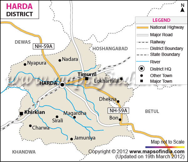
| *Harda District Map highlights the National Highways, Major Roads, District Headquarter, etc in Harda. | Disclaimer |
The district of Harda holds a total area of 998.41 sq. km.
The district has a population of 1,90,264.
The Harda district has a historical and religious significance. Harda district has given birth to many freedom fighters who selflessly sacrificed their lives for the independence of India.
Shri Siddi Vinayak Mandir, Shri Laxmi Narayan Bada Mandir and the Sivlinda at Shri Laxmi Narayan Bada Mandir are important places of tourist interest in the district.
Last Updated on : January 14, 2026
The district has a population of 1,90,264.
The Harda district has a historical and religious significance. Harda district has given birth to many freedom fighters who selflessly sacrificed their lives for the independence of India.
Shri Siddi Vinayak Mandir, Shri Laxmi Narayan Bada Mandir and the Sivlinda at Shri Laxmi Narayan Bada Mandir are important places of tourist interest in the district.
| Facts of Harda District | |
|---|---|
| State | Madhya Pradesh |
| District | Harda |
| District HQ | Harda |
| Population (2011) | 2032036 |
| Growth | 24.50% |
| Sex Ratio | 864 |
| Literacy | 76.65 |
| Area (km2) | 3339 |
| Density (/km2) | 171 |
| Tehsils | Handiya, Harda, Khirkiya, Rehatgaon, Sirali, Timarni |
| Lok Sabha Constituencies | Betul |
| Assembly Constituencies | Timarni (ST), Harda |
| Languages | Malwa, Nimad, Harda, Hindi |
| Rivers | Narmada, Ganjaal, Maachak |
| Lat-Long | 22.207749,77.111435 |
| Travel Destinations | Riddeshwar Mandir, Nemawar Narmada Ghat, Charwa Mandir, Mahabharat Era Chakraview, Cheepaner Ghat, Shri. Siddhi Vinayak Mandir, Shri. Laxmi Narayan, Bada Mandir , BadaMut Gonda Gaon, Kanha baba mandir, Ram Janki Mandir, Makdai Mandir, Kala Kriti, Bada Mut, Chota Mut, Kala Kriti, Goumukh etc. |
| Government Colleges/Universities | Govt Arts and Commerce PG College, Govt Degree College (Timarni) etc. |
Last Updated on : January 14, 2026