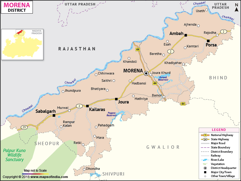
Morena is one of the northern most districts of Madhya Pradesh
and part of the great Chambal area. With Morena town as the headquarters, the district has a total area of 4998.78 square kilometers and a population of 1279.09 thousands.
Agriculture is the main source of occupation with mustard and wheat being the most important agricultural products.
Morena has great potential as a tourist destination and one can find many places of interest to visit. The National Chambal Sanctuary, the Fort of Sabalgarh and Kutwar are few examples of such exciting spots.
Last Updated on : January 14, 2026
Agriculture is the main source of occupation with mustard and wheat being the most important agricultural products.
Morena has great potential as a tourist destination and one can find many places of interest to visit. The National Chambal Sanctuary, the Fort of Sabalgarh and Kutwar are few examples of such exciting spots.
| Facts of Morena District | |
|---|---|
| State | Madhya Pradesh |
| District | Morena |
| District HQ | Morena |
| Population (2011) | 1091854 |
| Growth | 14.01% |
| Sex Ratio | 920 |
| Literacy | 75.69 |
| Area (km2) | 4991 |
| Density (/km2) | 394 |
| Tehsils | Morena, Ambah, Porsa, Joura, Sabalgarh, Kailaras |
| Lok Sabha Constituencies | Morena |
| Assembly Constituencies | Sabalgarh, Joure, Sumawali, Morena, Dimani, Ambah (SC) |
| Languages | Hindi |
| Rivers | Chambal, Kunwari, Asan, Sank |
| Lat-Long | 26.382028,77.836532 |
| Travel Destinations | Kakan Math Temple, Jain Temple, Harrisiddhi Devi temple, Vishnu Temple, Yogini temple, The fort of Sabalgarh, Pahadgarh Caves, Nurabad etc. |
| Government Colleges/Universities | Govt College (Joura), Govt Girls College, Govt College (Porsa), Govt PG College, Law College, Govt Nehru College (Sabalgarh) etc. |
Last Updated on : January 14, 2026
|
|
