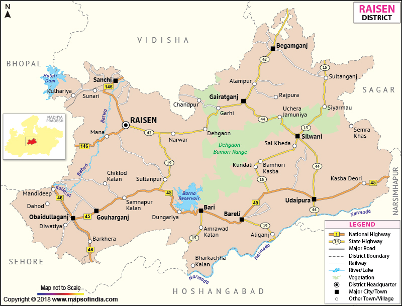
Raisen is a distinct district of the state of Madhya Pradesh
and lies between north latitude 22? 47' to 23? 33' and east longitude 77? 21' to 78? 49'. With the district headquarters situated at Raisen town, the total area of the district is 8,395 square kilometers and has a population of 1,20,159.
The economy of the district is agriculture based and wheat, pea and soybean are the main crops cultivated.
Raisen is a dream destination for tourists and holiday seekers. Places like Sanchi, Bhojpur and Bhimbhetika are full of historical and natural attractions.
Last Updated on : January 14, 2026
The economy of the district is agriculture based and wheat, pea and soybean are the main crops cultivated.
Raisen is a dream destination for tourists and holiday seekers. Places like Sanchi, Bhojpur and Bhimbhetika are full of historical and natural attractions.
| Facts of Raisen District | |
|---|---|
| State | Madhya Pradesh |
| District | Raisen |
| District HQ | Raisen |
| Population (2011) | 1545814 |
| Growth | 23.26% |
| Sex Ratio | 956 |
| Literacy | 61.21 |
| Area (km2) | 8466 |
| Density (/km2) | 157 |
| Tehsils | Raisen, Goharganj, Begamganj, Gairatganj, Silwani, Bareli, Udaipura, Badi |
| Lok Sabha Constituencies | Hoshangabad |
| Assembly Constituencies | Udaipura, Bhojpur, Sanchi (SC), Silwani |
| Languages | Hindi |
| Rivers | Narmada, Betwa, Bina |
| Lat-Long | 23.241346,78.188896 |
| Travel Destinations | Sanchi Stupas, Ashoka Pillar, Buddhist Vihara, Great Bowl, Gupta Temple, The Museum, Bhojeshwar Temple, Bhimbethika, Raisen Fort, Dargah Sareef etc. |
| Government Colleges/Universities | Govt PG College (Bareli), Govt College (Gairatganj), Govt College (Obedullaganj), Govt Girls College, Govt College (Udaipura), Pandit Deendayal Upadhyay Govt College (Begamgunj), Govt Arts, Commerce and Science College (Govt Arts, Commerce and Science College, Mandideep), Swami Vivekanand Govt College, Govt College (Silwani) etc. |
Last Updated on : January 14, 2026
