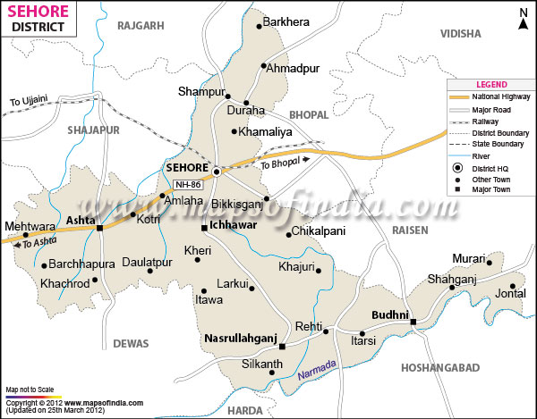
One of the important districts of
Madhya Pradesh
, Sehore is only 39 kilometers away from the state capital
Bhopal. Lying between the north latitude 22?31' to 23?40' and east longitude 76?22' to 78?08', the district's headquarters is situated at the Sehore city.
Agriculture and industries Related to agricultural products form the main source of occupation in Sehore district.
Several places of archaeological and historical significance are present in the Sehore district. One should visit the Ganesh
| Facts of Sehore District |
|---|
| State | Madhya Pradesh |
| District | Sehore |
| District HQ | Sehore |
| Population (2011) | 1379131 |
| Growth | 18.22% |
| Sex Ratio | 982 |
| Literacy | 72.12 |
| Area (km2) | 6578 |
| Density (/km2) | 199 |
| Tehsils | Sehore, Ashta, Ichhawar, Budni, Nasrullahganj, Shyampur, Rehti, Jawar |
| Lok Sabha Constituencies | Bhopal |
| Assembly Constituencies | Budhni, Ashta (SC), Ichhawar, Sehore |
| Languages | Hindi |
| Rivers | Narmada, Parvati, Ajnal, Kolar, Utawali, Seep, Amber, Seewan, Kaliasot, Nevaj, Dudhi |
| Lat-Long | 23.213583,77.079678 |
| Travel Destinations | Ganesh Mandir, Cenotaphs Of Kunwar Chain Singh, Jama Masjid, Jain Mandir, Hanuman Phatak, Church, Gurudwara, Ramlala Mandir, Salkanpur Durga Temple, Saru-Maru Caves etc. |
| Government Colleges/Universities | Govt Degree College (Ashtha), Govt College (Budhni), Govt Degree College (Ichhawar), Govt College (Rehti), Govt Girls College, Govt College (Baktara), Govt College (Dobi), Govt Degree College (Nasrullaganj), Chandra Shekhar Azad Govt PG Nodal College, Govt College (Ladkui) etc. |
Last Updated on : January 14, 2026
