|
|||||||||||
 | |||||||||||
|
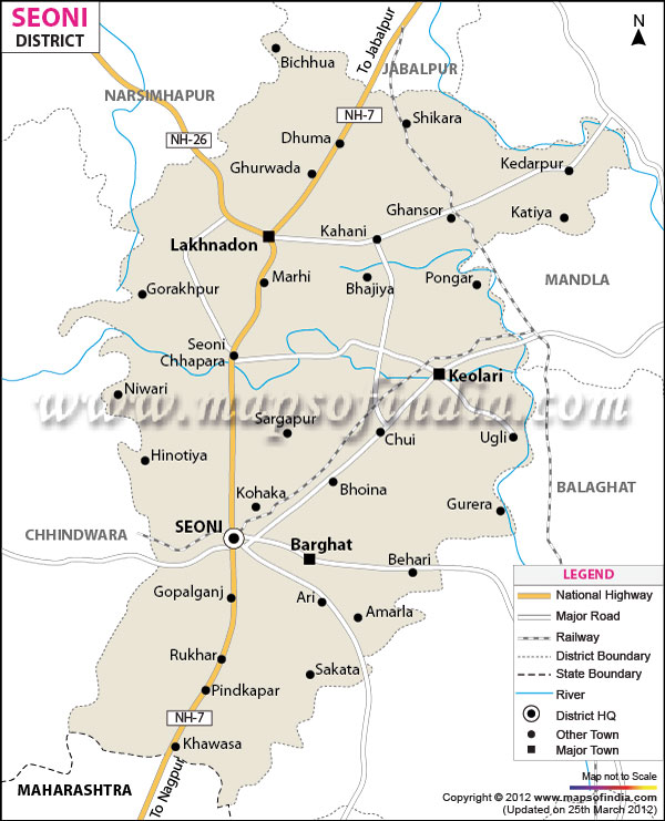
| *Seoni District Map highlights the National Highways, Major Roads, District Headquarter, etc in Seoni. | Disclaimer |
Seoni, one of the important tribal districts of Madhya Pradesh
is located between 21?36' and 22?57' north latitudes and 79?19' to 80? 17' east longitudes.
The headquarters of the district is located at the Seoni town and the total population of the district is 11,66,608. The total geographical area of Seoni district is 8,758 square kilometers.
Seoni's economy banks heavily on the rich timber resources of the district.
Wild life lovers will love Seoni for its abundance of forests and a visit to the Pench Tiger Sanctuary can be a life time experience
Last Updated on : January 14, 2026
The headquarters of the district is located at the Seoni town and the total population of the district is 11,66,608. The total geographical area of Seoni district is 8,758 square kilometers.
Seoni's economy banks heavily on the rich timber resources of the district.
Wild life lovers will love Seoni for its abundance of forests and a visit to the Pench Tiger Sanctuary can be a life time experience
| Facts of Seoni District | |
|---|---|
| State | Madhya Pradesh |
| District | Seoni |
| District HQ | Seoni |
| Population (2011) | 1066063 |
| Growth | 17.39% |
| Sex Ratio | 974 |
| Literacy | 66.67 |
| Area (km2) | 8758 |
| Density (/km2) | 157 |
| Tehsils | Barghat, Chhapara, Dhanora, Ghansaur, Keolari, Kurai, Lakhnadon, Seoni |
| Lok Sabha Constituencies | Balaghat |
| Assembly Constituencies | Barghat (ST), Seoni, Keolari, Lakhnadon (ST) |
| Languages | Hindi |
| Rivers | Wainganga |
| Lat-Long | 22.088185,79.544935 |
| Travel Destinations | Sona Rani's Palace, Bhimgarh Sanjay Sarovar Dam, Pench Tiger Reserve etc. |
| Government Colleges/Universities | Govt Degree College (Barghat), Govt College (Ghansor), Swami Vivekanand Govt College (Lakhnadon), NSCB Govt Girls College, Govt Degree College (Chhapara), Govt Arts and Commerce College (Keolari), Govt PG College etc. |
Last Updated on : January 14, 2026