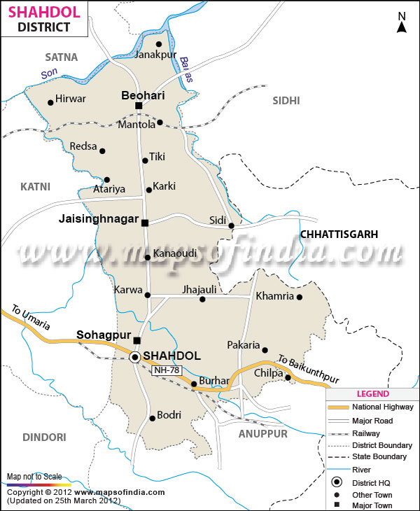
With a total area of 5,671 square kilometers and a population of 9,08,148, Shahdol is an important district of
Madhya Pradesh
. As per globe its is located between north latitude 22?38' to 24?20' and east longitude 30?28' to 82?12'.
With the headquarters located at Shahdol town, the backbone of the district's economy is
its coal mines and other mineral resources.
The Virateshwar Temple in Sohagpur Vangana is the most important tourist destination of Shahdol and a structural masterpiece.
| Facts of Shahdol District |
|---|
| State | Madhya Pradesh |
| District | Shahdol |
| District HQ | Shahdol |
| Population (2011) | 1512681 |
| Growth | 17.20% |
| Sex Ratio | 938 |
| Literacy | 69.09 |
| Area (km2) | 6205 |
| Density (/km2) | 172 |
| Tehsils | Beohari, Jaisinghnagar, Sohagpur, Jaitpur |
| Lok Sabha Constituencies | Shahdol |
| Assembly Constituencies | Beohari (ST), Jaisinghnagar (ST), Jaitpur (ST) |
| Languages | Bagheli, Hindi |
| Rivers | Son, Kunuk, Banas |
| Lat-Long | 23.644524,81.451034 |
| Travel Destinations | Virateshwar temple, Banasagar Dam etc. |
| Government Colleges/Universities | Govt. Pt Ramkishor Shukl Smriti Govt Arts & Commerce College (Byohari), Govt College (Jaitpur), Govt Abhayanand Sanskrit College (Kalyanpur), Govt Indira Gandhi Home Science Girls Degree College, Govt Nehru PG College (Burhar), Govt College (Jaisinghnagar), Pt Shambhoo Nath Shukla Govt PG College etc. |
Last Updated on : January 14, 2026
