|
|||||||||||
 | |||||||||||
|
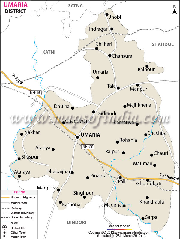
| *Umaria District Map highlights the National Highways, Major Roads, District Headquarter, etc in Umaria. | Disclaimer |
Umaria is an important north eastern district of Madhya Pradesh
, having a global location between north latitude 23?38' to 24?20' and east longitude 80?28' to 82?12'.
The total geographical area of the district sums up to 4548 square kilometers and has a population of 5,15,963.
Umaria is enriched with its vast resources of forests and minerals. The coal mines are a steady source of revenue for the district.
Umaria has many places of interest for the tourists and the Bandhavgarh National Park will definitely head the list.
Last Updated on : January 14, 2026
The total geographical area of the district sums up to 4548 square kilometers and has a population of 5,15,963.
Umaria is enriched with its vast resources of forests and minerals. The coal mines are a steady source of revenue for the district.
Umaria has many places of interest for the tourists and the Bandhavgarh National Park will definitely head the list.
| Facts of Umaria District | |
|---|---|
| State | Madhya Pradesh |
| District | Umaria |
| District HQ | Umaria |
| Population (2011) | 1458875 |
| Growth | 20.09% |
| Sex Ratio | 896 |
| Literacy | 70.53 |
| Area (km2) | 4062 |
| Density (/km2) | 158 |
| Tehsils | Bandhavgarh (Umaria), Chandia, Nowrozabad, Manpur, Pali |
| Lok Sabha Constituencies | Shahdol |
| Assembly Constituencies | Bandhavgarh (ST), Manpur (ST) |
| Languages | Bagheli, Hindi |
| Rivers | Son, Johila |
| Lat-Long | 23.614329,81.067314 |
| Travel Destinations | Bhandav Garh National Park, Bandhavgarh Fort, Chandia Khas, Pali Birsinghpur, Umaria Town etc. |
| Government Colleges/Universities | Ran Vijay Pratap Singh Govt College, Govt College (Birsinghpur-pali) etc. |
Last Updated on : January 14, 2026