Nizamabad District Map (Telangana) |
|
||||||||||
 | ||||||||||
|





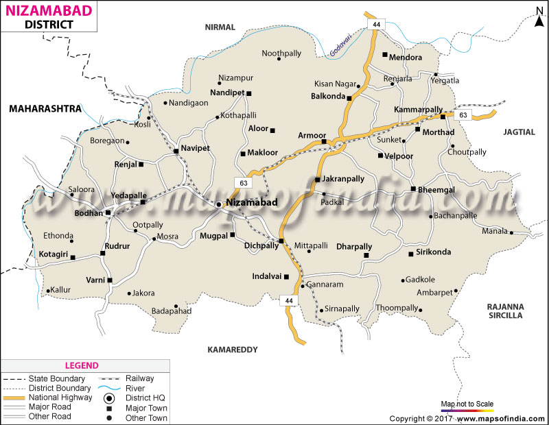
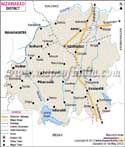
| *Nizamabad District Map highlights the National Highway, Major Roads, District Headquarter, etc in Nizamabad. |
| Districts of Telangana |
 |
 |
 |
 |
| Adilabad District Map | Nalgonda District Map | Mahbubnagar District Map | Medak District Map |
 |
 |
 |
 |
| Khammam District Map | Warangal District Map | Rangareddi District Map | Karimnagar District Map |
 |
 |
||
| Nizamabad District Map | Hyderabad District Map | ||
About
Whilst a quick perusal of a well-detailed Nizamabad district map reveals an ethereal land of calm waters and stubble-less sprawling greenery, with the rise of ancient granite hillocks above it. The district was once known as Indur, after King Indradatta who ruled these fertile lands in antiquity, but was later named Nizamabad in honour of the respected ruler of the former Hyderabad State, Nizam-ul-Mulk.
When the daunting Nizamabad district map is spread out, it is immediately evident how the latter subsumes the former throughout its vast expanse. Nirmal forms the northern border and Jagtial and Kamareddy the eastern and southern boundaries while the western boundary is the vast state of Maharashtra, making it a territorial gem in an enviable geographical location. The soil here is parched and the gentle flow of the sacred Godavari, which quenches the thirsty soil along its northern edge, has been the largest enabler for crop production in Telangana.
History & Culture
Well before the dawn of modern geographers' drawing of the first accurate Nizamabad district map, these ancient lands had an exciting history of empires rising and falling. The Rashtrakutas, the Chalukyas and the Kakatiyas followed in doing something that was unmatched: they began to engrave basalt stones into roads and forts that were so grand that they could not be built out of any other materials, and endowed this land with stone temples of incomparable artistic prowess. Years turned into centuries and the land was eventually controlled for over five centuries by the Qutb Shahi and then the Asaf Jahi Nizams, whose respective governments marked a lasting impression on the region in terms of architecture and culture.
In the year 1905, the district officially adopted its present name, abandoning the old name Indur which fell out of use due to the restructuring of administration that swept across the land. But, despite the peaceful appeal of its idyllic landscapes, the earth of Indur was also immensely ambitious to be free. During the historic Telangana Peasant Armed Rebellion in the middle of the last century, the peasants and gallant freedom fighters of those days protested against feudal rule.
Communities hold on to the festivals with the same fervour, such as the festival of Eid-ul- Fitr, Diwali, Ganesh Chaturthi and the Muharram with a deep sense of community harmony. Here, the culinary arts are a feast for the senses; flavorful dishes, with a generous quantity of spices, crispy sarva pindi, tangy pacchi pulusu and rich, aromatic Deccani biryani, all reflecting the rich culinary traditions of the Deccan.
Economy
A close look at the economic area through the Nizamabad district map immediately gives an idea of bustling trade routes and wide tracts of farmland. Nizamabad is known for its turmeric and is often called the 'Turmeric City'. Huge patches of a lush green convert to a golden bunch of turmeric and make the local agri market yard one of the most conspicuous trading hubs in Asia for the special spice. Local farmers grow high-quality paddy and sugarcane, maize and cotton crops along intricate canal and natural reservoir systems, along with this golden crop.
In the Government sector, the government's interventions continually reinvigorate the financial dynamism of the district. Most importantly, massive hydraulic projects like the Sriram Sagar and the Nizam Sagar projects of hydraulic structures provide water to hundreds of thousands of hectares of agriculture, protecting rural livelihoods from drought. The regional economic machine is kept in proper running condition by the government administrative agencies in the form of agricultural subsidies, rural employment guarantee schemes and infrastructural investments on a regular basis.
Historically, the Public Sector has been the keystone of the region's industrial base. The Nizam Sugar Factory at Bodhan was once the hulking industrial giant that dominated the economy for decades and made its mark in Asia. The modern government bodies, such as the Telangana State Industrial Infrastructure Corporation (TSIIC), have now brought well-planned industrial corridors with reliable power and transportation infrastructure. The Nizamabad district map features strategic locations for warehouse networks for storage and delivery facilities.
Driven by an entrepreneurial spirit, the Services Sector and light manufacturing continue to flourish. The agro-processing sector is at the core of the industrial enterprise, with hundreds of modern rice mills, the ones used in spice-grinding, and the units for seed processing are clustered in the industrial areas as seen on the Nizamabad district map. At the same time, the urban centres of the districts – Nizamabad, Armoor and Bodhan – have become vibrant service centres. This agrarian citadel is now a modern economy thanks to the steady employment opportunities that can be found in the modern complexes of healthcare, financial banking institutions in the region, increasing educational academies and growing logistics enterprises.
Tourism
The trek through a portion of the area outlined in a Nizamabad district map reveals a completely amazing mixture of centuries-old architectural splendour and quiet nature. The famous Nizamabad Fort, built by the Rashtrakuta rulers in the 10th century and strengthened by the rulers down the centuries, proudly stands on a monolithic hill overlooking the main city. Instead, making its way through its ancient stone stairs, one would find the famed Raghunath temple, which was built under the spiritual leadership of Saint Samarth Ramdas. Gorgeous views from the fort's intimidating walls sweep out over the city and into the countryside.
On a Nizamabad map, if you follow the roads farther north, it is an amazing sight to behold the extensive expanses of water in the dam of Sriram Sagar. Located on the banks of the mighty Godavari River, this massive reservoir turns into a massive lake which draws nature lovers, photographers, as well as weekend tourists looking for relaxation by the lake. Just a stone's throw away, Alisagar Deer Park beckons with its groomed, manicured lawns, still lakes and a natural sanctuary where deer freely roam under the trees, continuing the royal pastimes of the Nizam era.
As you head off to Sirur towards Ashok Sagar, you will see an enchanting kingdom, containing artistic rock gardens, footpaths, and a majestic stone statue of Lord Hanuman standing in a serene landscape. The Dichpally Ramalayam is considered a “Khajuraho of Telangana” and is designed to captivate the architectural purists. It is made of dark basalt stone and its external walls are made by the Kakatiya craftsmen with amazingly detailed designs of dancing heavenly figures, floral designs and other ancient legends! For the more adventurous, Mallaram Forest has eco-tourism paths, impressive rock formations and tranquil trails secluded from city noise.
Demographics
An analysis of the population's demographic breakdown within a Nizamabad district map shows a diverse, harmonious and resilient population. The district is influential in terms of human presence; even after the important administrative demarcation of its boundaries, it has a population of more than 1.57 million people. Much of this population is found in rural hamlets and traditional agricultural villages, living a life pattern testifying to the age-old existence trends, but slowly softening under the influence of the modern economy. The region's gender ratio remains suitably well-balanced, indicative of appropriate social balance throughout the region, both in rural and municipal settings.
Educational availability is increased to all corners of the Nizamabad district map and literacy has continued its upward growth. The district-wide literacy rate is about 64.25%, of which the literacy levels in the municipal regions of Nizamabad city, Bodhan and Armoor are fairly high. With the formation of Telangana University at Dichpally, hundreds of professional colleges and specialised vocational schools have equipped the youth of the region with a skilled workforce for modern employment.
Language harmony is seen in day-to-day contact throughout the district. The Telugu language is used by the majority of inhabitants and is the language of the majority of regional administration, media and literature. Urdu has a great historical background and is a widely spoken language, mostly used by the people in the urban areas, where they have rich cultural expressions for Deccani origins. Moreover, due to the geographical adjoining with Maharashtra, Marathi is comfortably spoken along with Hindi/English among all settlements in the northern part of the district, resulting in a culturally rich ambience in a multilingual setting.
Administration
The Nizamabad district map for the area shows the structure of governance, which is based on three main revenue divisions, such as Nizamabad, Bodhan and Armoor. These administrative units guarantee that public services, infrastructure construction and law enforcement are available to all citizens. District Collectorate in Nizamabad city is the centre of all activities related to planning, revenue monitoring and by extension the civil administration of the district.
The district is divided into 33 mandals (tehsils) to provide responsive local-level administration. These consist of Nizamabad Urban, Nizamabad Rural, Armoor, Bodhan, Balkonda, Bheemgal, Dichpally, Varni, Kotagiri and Renjal, etc., administrative units. Every mandal has a Mandal revenue officer, who is responsible for maintaining land records, public welfare execution, and also supplies public services.
In essence, the grassroots constitute over 530 revenue villages as the base of the society. The gram panchayats manage the rural roads, water management and sanitation of the countryside and, in this manner, guarantee progress in the rural regions. The Nizamabad Municipal Corporation and its key municipalities, Bodhan and Armoor, on the other hand, are influencing urban governance. Each boundary drawn along the roads on the official Nizamabad district map portrays a well thought-out plan in keeping the peace, fostering development and enhancing welfare in every corner of the historic land.z
FAQs
Q1: What was the historic name of the district?
It was named Indur after King Indradatta.
Q2: What is the district's population?
The population exceeds 1.57 million people.
Q3: How many revenue villages are there?
There are over 530 revenue villages.
Q4: What is the literacy rate?
The literacy rate is approximately 64.25 per cent.
Q5: What crop is it famous for?
It is famous for massive turmeric production.
Q6: Which major river flows nearby?
The Godavari River flows along its border.
Q7: How many revenue divisions exist?
There are three main revenue divisions.
Last Updated on : August 05, 2026
