





| Karimnagar District Fact Sheet | |
|---|---|
| District | Karimnagar |
| Headquarters | Karimnagar |
| Population (2011) | 3811738 |
| Area ((/km2)) | 11823 |
| Denisty ((/km2)) | 322 |
| Major Minerals: | Coal, Stowing Sand, Lime stone |
| Minor Minerals: | Black Granites, Colour Granites, Stone and Metal, Gravel, Lime Kankar, Bricks Sand |
| Rivers | Godavari, Manair |
| Literacy | 0.6487 |
| Forest Area under the control of Forest Department (Area in Hectares) | 2,50,410 |
| Temple | Vemulavada Kondagattu, Koti Lingala Raikal Dharmapuri, Karimnagar |
| Languages Official | Telugu, Urdu |
| Mandals | Bejjanki, Bheemadevarpalle, Boinpalli, Chandurthi, Chigurumamidi, Choppadandi, Dharmaram, Dharmapuri, Eligedu, Elkathurthi, Ellanthakunta, Gambhiraopet, Gangadhara, Gollapally, Husnabad, Huzurabad, Ibrahimpatnam, Jagtial, Jammikunta, Julapalli, Kalva Srirampur, Kamalapur, Kamanpur, Karimnagar, Kataram, Kathlapur, Kesavapatnam, Kodimial, Koheda, Konaraopeta, Korutla, Mahadevpur, Malhar, Mallapur, Mallial, Manakondur, Manthani, Medipalli, Metpally, Mustabad, Muttaram-Mahadevpur, Muttaram-Manthani, Odela, Peddapalli, Pegadapalle, Raikal, Ramadugu, Ramagundam, Saidapur, Sarangapur, Sirsilla, Sultanabad, Thimmapur, Veenavanka, Velgatoor, Vemulawada, Yellareddipet |
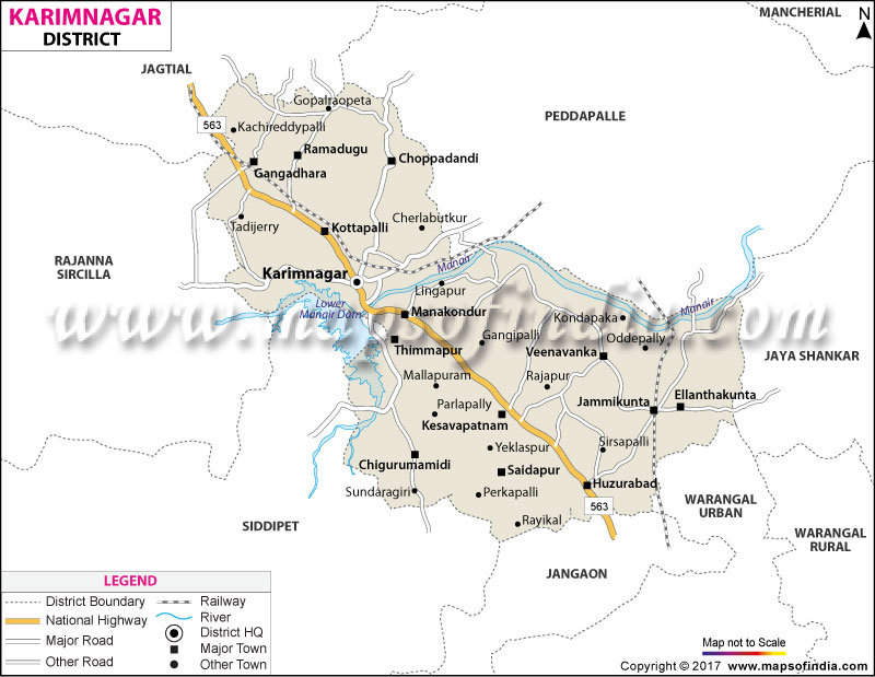
Karimnagar District Map (Telangana) |
|
||||||||||
 | ||||||||||
|
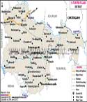
| *Karimnagar District Map highlights the National Highway, Major Roads, District Headquarter, etc in Karimnagar. |
| Districts of Telangana |
 |
 |
 |
 |
| Adilabad District Map | Nalgonda District Map | Mahbubnagar District Map | Medak District Map |
 |
 |
 |
 |
| Khammam District Map | Warangal District Map | Rangareddi District Map | Karimnagar District Map |
 |
 |
||
| Nizamabad District Map | Hyderabad District Map | ||
About
An active and historical administrative district is the Karimnagar district in the northern part of the Telangana state in India. Geographical extent as shown in the map of Karimnagar district shows the border with Rajanna Sircilla district in the west, Jagtial and Peddapalli districts in the north, Siddipet district in the south-west, Jayashankar Bhupalpally district in the east and Hanamkonda district in the south. It is a big urban, commercial and educational centre with its district headquarters in the city of Karimnagar which is approximately 115 kilometres from the southern city of Hyderabad.
The word district and its name are quite historical in nature. The area was known as Sabbinadu in ancient and medieval times, which became a centre of administration, trade and learning under several reigning dynasties. This current name was coined during the time of the Nizam of Hyderabad, suggesting that it was named after Syed Karimuddin, a foremost Killadar (fort commander). The name is also said to be of the revered Sufi saint Shahenshah E Karimnagar Syed Kareemullah Shah Quadri. The name changed over the centuries to Karimnagar - City of Karim.
The district is endowed with rich agricultural productive potential coupled with the industrial cluster, which is playing a significant role in the socio-economic matrix of Telangana. It is known worldwide for its fine handicraft work in silver filigree, a highly intricate filigree technique which has been granted the title of Geographical Indication. Furthermore, this zone is known for its enormous granite deposits, a significant region of paddy farming and its ancient history, which smoothly blends with the modernisation of the city. Moreover, this zone is famous for its huge deposits of granite minerals, large-scale cultivation of paddy fields, and its rich history of thousands of years, which perfectly connects to the modern urbanisation.
History & Culture
The region has a rich history, dating back to prehistoric times, as early as the Stone Age (c. 1,48,000 BCE), when people lived at the site. From all over the region, the remains of ancient tools, megalithic burial graves and structural ruins were uncovered and present an unbroken line of human civilisation. To understand the evolution of historical Sabbinadu, a comparison was made with the historical map of Karimnagar district with the map of ancient times. In the classical period, the area was the birthplace of the Satavahana Empire.
The ruins of the earlier settlements of the Satavahana can be referred to on a detailed Karimnagar district map and so it's clearly established that the old capital of the Satavahana dynasty was at Kotilingala, dating from the 3rd century BCE. Inscriptions found at the local sites offer copious information on government under Mauryan influence, under Kakatiya kings like Prola II and Prataparudra, the Bahmani Sultanate, the Qutb Shahi dynasty of Golconda and finally Asaf Jahi Nizams of Hyderabad.
The culture in the region is steeped in history with rich social life, classical art forms and large-scale religious festivals, all of which are Telangana traditions. Filigree is a fine art practised by native silversmiths for centuries throughout the district. They produce beautiful jewellery, utensils and decorative items still in the gold rush style. The region's ancient art markets, where fine silver filigree craftsmanship is carried out, are clearly identified on the map of the area of Karimnagar. Colourful festivals like the Bathukamma festival of concentric flowers for devotion to the Goddess Mother or the festival of Goddess Mahakali Bona, dominate the cultural calendar. Dasara, Sankranti, Ugadi, Diwali, Eid-ul-Fitr and Milad-un-Nabi are also celebrated on different levels with the same spirit, showing that there is a blend of Hindu and Islamic culture.
Economy
The economy of the area is diverse with sound agricultural production, growing industrialisation, and a vibrant services sector. On the economic Karimnagar district map, agricultural lands and farmlands adjacent to Manair-River basin are clearly visible. The district is mostly known for the cultivation of paddy which is irrigated from the Lower Manair Dam and a number of canals in the district, and is known as a major rice bowl in Telangana. Maize, pulses and sugarcane, apart from rice, are the major crops grown by farmers. A large section of the commercial Karimnagar district map is used to show the area of the industrial corridor and granite processing units. The district is known throughout the world for the production of its two types of granite, Tan brown and Maple Red, blocks of which are exported to markets in Asia, Europe and America.
In terms of sectoral economic breakdown, the Government Sector can provide the pivotal foundational support by supporting funding for large irrigation schemes, supporting rural infrastructure projects and civic works. State government initiatives like Mission Kakatiya and these various agricultural support schemes have rejuvenated water bodies and improved their productivity in terms of harvesting of crops, vegetables, etc. Any government Karimnagar map features the public sector and infrastructure developments as important calls out. In addition, the government's support for the industrial estates and handloom cooperatives provides avenues for structured growth opportunities for artisans and businesspeople.
The Public Sector (and in the case of large-scale industrial/public partnerships) has been a catalyst for the growth of the region. Apart from the major public sector companies like NTPC at Ramagundam and Singareni Collieries Company Limited that were formed after the administrative reorganisation by linking the district with several others, such companies continued to be economically interconnected with Karimnagar. Tens of thousands of local families are assured jobs, as well as civic services, from public banking institutions, state transportation companies, and warehousing companies.
The district's economy has evolved into the fastest growing one in terms of the contribution of the Services Sector. Over a dozen years, Karimnagar town has grown into a focal point for education and medical activity for the nearby rural districts with scores of engineering colleges, medical institutes, polytechnics and corporate hospitals. The core sectors of urban employment are retail trade, telecommunication, hospitality, transport and banking services that employ a significant number of skilled and semi-skilled workers.
Tourism
From the formidable hill forts and antiquity of ancient temples to the tranquil beauty of the reservoirs and verdant urban parks, the region has plenty of sightseeing experiences available. The historic Elgandal Fort is one of the top heritage sites that can be seen on a tourist map of the Karimnagar district. Elgandal Fort is an architectural wonder perched on a hill approximately 10 kms away from the District headquarters on the banks of the Manair River. Nagunur Fort has the remains of several gorgeous triple-shrine temples constructed during the Kakatiya reign, which contain very fascinating carvings like those of the ‘Warangal' style.
Many tourists visit to enjoy Lower Manair Dam and Ujwala Park that are showcased following a map of the local district of Karimnagar. Lower Manair is a large engineering feat, built over the Manair River, that is also a popular recreation site. Ujwala Park, a tastefully designed garden offering peaceful ambience, boating amenities and recreational areas, is located next to the dam. However, at nearby Deer Park, visitors can enjoy seeing the spotted deer and wild birds, which is a much favored place among the eco-tourists and families.
It is important to mention the surrounding spiritual landmarks and pilgrimage corridors which constitute a separate circuit on a thorough knowledge map of the district of Karimnagar. The district is conveniently located near the world-famous pilgrimage sites like the Sri Raja Rajeshwara Swamy temple at Vemulawada, Kondagattu Anjaneya Swamy temple, and Sri Lakshmi Narasimha Swamy temple at Dharmaburi. Recently, a project known as Manair Riverfront has been developed, which has improved the urban tourism and modernised promenades, entertainment areas and facilities for water sports along the riverbank.
Demographics
Post-restructuring of districts in Telangana in October 2016, the geographical boundaries were improved in order to achieve better administrative efficiency. However, a demographic map of the district Karimnagar is perfectly clear in terms of density distribution and urban cluster developments. The district has a population of 10,05,711 people and the area of the district is about 2128 sq km as per official census data. A well-balanced sex ratio is observed, with 993 females per 1 000 males.
A very impressive literacy figure for the district is 69.16 %, above the average of many of the other rural districts of the state. The figures are remarkable because the level of urban literacy in the city of Karimnagar is more than 85%, with a significant concentration of educational institutions and educational awareness in the city. Telugu is the major and official language of the majority of the population and forms the basic part of the communication and literature of the population throughout its life. Urdu is also a widely used language and it is an official second language in Telangana, especially in urban areas. Apart from that, Hindi and English are widely used and widely understood in business, advanced education and also administrative work communications.
Administration
The district governance and administration are established to create improved facilitation for decentralised development and effective provisioning of public services. Referring to an administrative Karimnagar district map, we can understand the district administrative is divided into two revenue divisions and sixteen mandals. There is a District Collector & District Magistrate who is the head of the district for law & order and land revenue administration and has the responsibility for planning developmental schemes. The district has been divided into two revenue divisions for administrative ease, namely Karimnagar and Huzurabad.
The boundaries of rural governance and the networks of revenue administration at the village level are plotted with accuracy on an updated map of the Karimnagar district. The district consists of 16 mandals or tehsils, these being the most fundamental units of administering the local government. These mandals include Karimnagar, Karimnagar Rural, Kothapalli, Choppadandi, Ramadugu, Gangadhara, Manakondur, Thimmapur, Ganneruvaram, Chigurumamidi, Huzurabad, Jammikunta, Veenavanka, Saidapur, Ellandakunta, and Shankarapatnam. These 16 mandals encompass more than 210 revenue villages, wherein each village has a gram panchayat at the bottom level. The Karimnagar Municipal Corporation and municipal councils in prominent town centres plan, clean and manage urban areas to ensure proper management of structures.
FAQs
Q1: What is the population of Karimnagar district?
It has a population of 1,179,303.
Q2: How many revenue villages are there?
It has 210 revenue villages.
Q3: How many mandals are there?
It has 16 mandals.
Q4: What is the literacy rate?
It has a literacy rate of 69.16%.
Q5: What is the district famous for?
It is famous for silver filigree, granite and paddy cultivation.
Q6: What is the district headquarters?
Its headquarters is Karimnagar city.
Q7: How many revenue divisions are there?
It has two revenue divisions.
Last Updated on : September 01, 2026
