





| Mahbubnagar District Fact Sheet | |
|---|---|
| District | Mahbubnagar |
| Headquarters | Mahbubnagar |
| Population (2011) | 4042191 |
| Area ((/km2)) | 18432 |
| Denisty ((/km2)) | 219 |
| Literacy | 0.5606 |
| Forest Area under the control of Forest Department (Area in Hectares) | 2,55,596 |
| Temple | Alampur Manyamkonda, Rama Giri Umamaheshwaram Vallabhapuram |
| Languages Official | Telugu |
| Mandals | Kodangal, Bomraspeta, Kosgi, Doulatabad, Damaragidda, Maddur, Koilkonda, Hanwada, Nawabpet, Balanagar, Kondurg, Farooqnagar, Kothur, Keshampeta, Talakondapalle, Amangal, Madgul, Vangoor, Veldanda, Kalwakurthy, Midjil, Thimmajipeta, Jadcherla, Bhoothpur, Mahbubnagar, Addakal, Devarkadara, Dhanwada, Narayanpet, Utkoor, Maganoor, Makthal, Narva, Chinna Chinta Kunta, Atmakur, Kothakota, Peddamandadi, Ghanpur, Bijinapalle, Nagar Kurnool, Tadoor, Telkapalle, Uppununthala, Achampeta, Amrabad, Balmoor, Lingal, Peddakothapalle, Kodair, Gopalpeta, Wanaparthy, Pangal, Pebbair, Gadwal, Dharur, Maldakal, Ghattu, Aiza, Waddepalle, Itikyal, Manopadu, Alampur, Veepangandla, Kollapur |
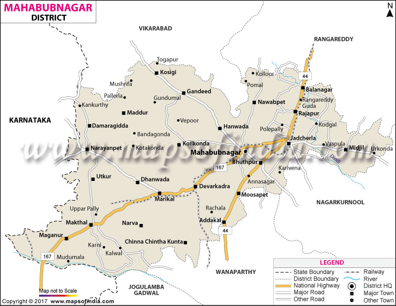
Mahbubnagar District Map (Telangana) |
|
||||||||||
 | ||||||||||
|
| *Mahbubnagar District Map highlights the National Highway, Major Roads, District Headquarter, etc in Mahbubnagar. |
| Districts of Telangana |
 |
 |
 |
 |
| Adilabad District Map | Nalgonda District Map | Mahbubnagar District Map | Medak District Map |
 |
 |
 |
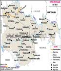 |
| Khammam District Map | Warangal District Map | Rangareddi District Map | Karimnagar District Map |
 |
 |
||
| Nizamabad District Map | Hyderabad District Map | ||
About
The historic Mahbubnagar district in the far northernmost part of the Telugu-speaking Telangana State was a bridge between the Deccan plateau and also a site influenced by the Industrial Revolution movement for many decades. Over the many generations, the term that came into very common use amongst locals was Palamoor (or Palamuru). And it was believed that the name was formed by the word Pala (milk) and Ooru (settlement or land). Milk had plenty due to dairy cattle and that fact had given the region such a name. The name shows the depth of the pastoral background of the region, cattle breeding activities which are still active and the land is historically nourished by the Krishna River and its tributaries. During the period of the Asaf Jahi dynasty in 1890 the name of the district was changed from Palamoor to Mahbubnagar, which means 'Place of Mahbub', that is where Mir Mahbub Ali Khan Asaf Jah VI, the sixth Nizam of Hyderabad, is being honored. To be a Palamoor which is equivalent of a very prominent headman is simultaneously a great honor and a heavy responsibility. It is just that the title still remains as Palamoor a favorite local name even though the formal designation is only. In addition, it reflects the kind of resolution of the folk artists, who are very close to the folk of this part of the region in their very way of art; the artists themselves have such an intimate relationship with the folk who live nearby. To the west it has Narayanpet district. Geographically, the area is like a gate to the south of the Hyderabad Metropolitan area and the terrain has rolling plains, mainly made up of granitic rocks with dry tropical forests scattered around them and also agricultural plains that are very fertile. The district has many attractions; for example, it is a heritage site. It has a 700-year-old Banyan tree named the Pillalamarri tree. Manyamkonda is a famous temple also present there. The area supports a large-scale seed production industry besides other sectors. Mahbubnagar is linked up by road and rail, via the National Highway 44 and some of the leading railway lines connecting towns; the district is a bridge between rural life and the development of the economy.
History & Culture
Mahbubnagar district's heritage is rooted in the Neolithic period which is evident from the stone mounds, dolmens and rock art found all over the district. For the past two millennia this area became the heartland of powerful dynasties like the Megadavas, Satvahanas, Chalukyas, Rashtrakutas, and Kakatiyas who apart from changing rulers also made major tank irrigation schemes and built fortifications. The region later flourished as a commercial and administrative hub under the Bahamani Sultanate, Golconda's Qutb Shahi dynasties and the Asaf-Jahi Nizams. The presence of several Sansthans or princely states such as Gadwal Wanaparthy, Kollapur, Jatprole and Amarchinta which were under the state but were more or less independently ruled, provided cultural niches that encouraged development of Telugu literature, performing arts and architectural styles. There is a lively atmosphere of festivalizing accompanied by folk performing traditions which give the region a very colorful and dynamic culture. In the district, festivals are observed with great exuberance and gaiety; Girams and Bathukamma, oral floral stacks are created by women, and drums are played, processions and the fire-walking rituals are performed on the open fields in the celebration of festivals, like Bonalu, in the popular worship of Goddess Mahakali. A remarkable synthesis of these is Peerla Panduga where the communities, Hindu and Muslim unitedly bringing historical Alams and joining together for fire speech meets which respect for indigenous ritual traditions and mythology.
Economy
The economy of Mahbubnagar district has experienced a profound change in the last two decades or so. From the traditional rooted economy it has taken the direction of a dynamic economy with modern irrigation systems, specialized industrial belts, large service sector.
Government Sector
The government sector is the biggest prime mover of rural stabilization, mega infrastructure development and region upgrading at the district level. With maximum high thresholds of irrigation projects under government flagship schemes like Palamuru-Ranga Reddy Lift Irrigation Scheme (PRLIS) which is lifting water for fallowing drought-prone drylands into pelletization, the region has received some critical geographical transformations in groundwater table as well as rural fisheries. Key regional canal networks like Koil Sagar and Jurala with the Mission Kakatiya initiative of tank restoration schemes are the backbone of these geographical changes.
Public Sector Footprint
To support the state-level development programs, Mahbubnagar is the hub for public sector bodies providing critical civic infrastructure, utilities, and managing a steady and dependable public job scenario. A lot of buses for the public come from the TGSRTC bus depots in Mahbubnagar and Jadcherla. These are operated so that villagers in remote areas are linked to economic hubs. TSSPDCL is responsible for the distribution of electricity and it ensures a constant supply of electricity for agriculture pumps, urban families, and industrial units. State-of-the-art warehouses and public health facilities - the Government General Hospital and Medical College are its pillars, providing the regional populace with essentials - civil supply, the storage of grain, and specialized care.
Services Sector Expansion
Rapid development of urban infrastructure, a new high-speed highway that runs along National Highway 44, and increased purchasing power of consumers have transformed the services sector into a significant source of jobs locally. Mahbubnagar town and Jadcherla are principal marketing hubs where farmers, building materials vendors, textile dealers and sellers of daily commodities bring their products to be sold in bulk. Nationalized banks, local rural banks through cooperatives, and credit societies have a great presence, which is very helpful for the growth of small rural micro-enterprises and small business expansion by providing them credit facilities.
Tourism
There are many tourist attractions in Mahbubnagar including centuries-old botanical gardens, hilltop forts, scenic lake reservoirs and ancient temples. Pillalamarri an old banyan tree of about 700 years, is one of them which can be found just four kilometers away from Mahbubnagar town and is considered very famous among all the tourist attractions there. This banyan covers about three large acres and now the trunk has been completely lost and there is a giant green top that has been entirely created with the help of the hundreds of supporting roots. Plus that, visitors can also tour the historical site and a museum displaying artifacts dating back to the 12th century together with a charming deer park amidst the surrounding botanical gardens. The Koilsagar Dam situated just beside the fort is a reservoir that flows over the Peddavagu nadi (stream) and looks very charming and is used by people coming for weekend camping, natural photography and relaxation. According to legends, ancient sadhus were supposed to have meditated there which made it very holy. The Jathara festival of the temple is held mainly in January every year and attracts huge numbers of devotees from various parts of Telangana, Karnataka, and Maharashtra. Mayuri Eco Park which is an urban nature reserve located at the city's periphery is one of the modern additions to these historic places. Here, there are well-kept hills of greenery, tree canopy paths, cycling trails, and spots for various thrilling activities.
Demographics
Post administrative reorganization in Telangana, the present-day Mahbubnagar district consists of a population of 40,53,028. The former district had a massive 4 million citizens in the 2011 Census records. Approximately 79% of people live in rural agricultural villages while about 21% are in burgeoning towns. Mahbubnagar being the biggest city, is reported to have a population of around 235,000, of which 93,400 are in urban areas. A demographic survey has identified a literacy rate at the district level of about 50.45% which is a result of the rural areas' long-term difficulties addressed lately by educational development initiatives. On the bright side, the city of Mahbubnagar has the highest literacy level in the district. The overall figure is 83.96%, with more than 90% of men literate and almost 78% of women. The district population ratio of female to male is very close and is 977 females/ 1000 males which is pretty much representative of the south Telangana demographic pattern. Among the spoken languages there are 84% Telugu speakers in the area. 1). It is one of the most beautiful and expressive dialects that has a good mix of Telugu, Arabic, and Persian with many native speakers and some of the most respected people of their community. 2). It also happens to be the language of the administration, the language of education, and the language of business. Urdu is spoken by about 12% of the residents and is quite common around Mahbubnagar city (the district headquarters), Jadcherla, and the old city areas to preserve the unique heritage of the area. On top of that, Lambadi is the language of many of the rural tribal village communities of the district. Kannada, Hindi, and English are among the many other languages spoken in the district. It should be mentioned though that they are not spoken regularly by local people except for commercial purposes and in higher educational centers.
Administration
Administratively, Mahbubnagar district is managed within the revenue divisions system of the Government of Telangana, with the power of the district administration lying largely with the District Collector and Magistrate. Two Revenue Divisions, Mahbubnagar and Jaycherla, are the main revenue divisions and are divided into 15 administrative mandals (tehsils) in total. They are major urban and commercial centers including Mahbubnagar urban, Mahbubnagar rural, Jagdherla Balanagar, Bhoothapur and Devar Kadrar while the others are engaged mainly in agriculture and historical activities like Nawabpet, Hanwada, Koilkonda, Addakal, Moosapet, Rajapur, Midjil, Gandeed and Chincholi. In rural areas, the government at the local level encompasses about 314 revenue villages whose numbers fluctuate to approximately 294 to 307 inhabited villages. Development is a combined effort of rural areas through 241 Gram Panchayats, which are the units of local self-government at which one is elected as a Sarpanch supported by a Panchayat Secretary.
| Facts of Mahbubnagar District | |
|---|---|
| Official Name | Mahbubnagar |
| Location | Telangana |
| Area (km2) | 7237 |
| Population | 40,53,028 |
| Language | Telugu, Urdu, Kannada |
FAQs
Q1: What is the population of Mahbubnagar district?
The district has a population of 40,53,028 people as per 2011.
Q2: How many villages are in Mahbubnagar district?
It has 314 inhabited villages.
Q3: What is the literacy rate of Mahbubnagar district?
The literacy rate is 44.79%.
Q4: Which language is mainly spoken in Mahbubnagar district?
Telugu is the main spoken language.
Q5: What is Mahbubnagar district famous for?
Mahbubnagar district is widely famous for Pillalamarri, a world-renowned 700-year-old Banyan tree spanning over three acres.
Last Updated on : September 01, 2026
