Mancherial District Map, Telangana |
|
||||||||||
 | ||||||||||
|





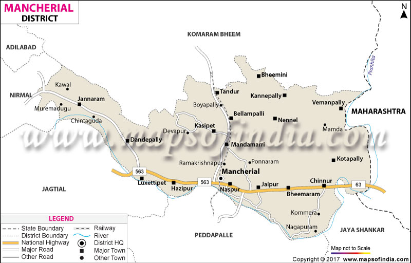
| *Mancherial District Map highlights the National Highway, Major Roads, District Headquarter, etc in Mancherial. |
| Districts of Telangana |
 |
 |
 |
 |
| Adilabad District Map | Nalgonda District Map | Mahbubnagar District Map | Medak District Map |
 |
 |
 |
 |
| Khammam District Map | Warangal District Map | Rangareddi District Map | Karimnagar District Map |
 |
 |
||
| Nizamabad District Map | Hyderabad District Map | ||
About
In the most northern part of Telangana, amidst the old teak forests, the sun's warm rays glide through the lush forests, yielding countless assortments of greenery, and the words of the old trees are cascading, the river Godavari presses on, and this area is under deep transformation. One can't help but look at any Mancherial district map and see a land intensely writhing between the shimmering force of industry and the rolling waves of the wild. This area is bordered by Komaram Bheem Asifabad, Adilabad, Nirmal, Jagtial, Peddapalli, Jayashankar Bhupalpally, and Maharashtra
This has given rise to the question of why the name Mancherial is so revered throughout the Deccan Plateau. But to know its identity, one must look at the Mancherial district map and follow the main origins of life that are the Godavari and the Pranahita rivers that surround and give birth to its fruitful boundaries. The area of Mancherial was carved out of the erstwhile Adilabad district during the massive administrative reorganisation of Telangana in October 2016, and named after the quiet agricultural town it was, which grew into a commerce hub.
As an observer gazes at the topographical map contours on a Mancherial district map, the stark contrast of black coalfields and dense green forest is immediately apparent. The juxtaposition, the challenge and the beauty of Mancherial district come from a sacred landscape where the natural world exists in purity and where the raw power of heavy industry thrives.
History & Culture
This was a land of dreams and visions long before heavy engines pounded across its river bridges. The study of this historical Mancherial district map enables one to tap into the imagination of the years during which the Chalukyas, the Rashtrakuta and later the powerful Kakatiya rulers reigned on these rich river courses.
Its weathered walls once boomed with the clash of swords and the insect trumpets of war elephants, protecting trade routes which connected the tablelands of the Deccan with the eastern coastal areas. Eventually, it came under the control of the Nizam of Hyderabad and transformed into a part of his vast estate but still maintained its strong independent agrarian culture.
Here, culture has its own dynamic flow, akin to that of the Godavari during violent Indian rains. The district is a blend of classical Telugu customs and colourful tribal culture. These ridges have been forested for a long time and were inhabited by the indigenous communities such as the Raj Gonds, Kolams and Naikpods for thousands of years. They have colourful ritual dances, elaborate wooden masks and hypnotic drumming accompanied by intricate dances embodying the spirits of ancestors and connecting to a world of living people in colourful festivals. A Mancherial district map can be useful to refer to festivities and their hotspots.
At the same time, customs of the traditional Hindu festival are being followed in the same live tempo. Pilgrims in hundreds of thousands flock to the sacred confluence of the river near Chennur during this rare river festival, the Pranahita Pushkaralu, which comes every 12 years, to take a holy dip in the river and perform rituals for the remission of sins.
Economy
Under the scorching sun of Mancherial, there's a treasure trove, nurturing the growth of a whole nation. This is an area that has an enormous mineral wealth that, accumulated over the centuries, is the basis of its economy. The state of the concentration of industrial architecture is better evident in an economic mapping of the district of Mancherial, showing an incredible population of industry within a fertile agricultural area.
Government Sector
The government has a basic responsibility in establishing rural and urban social welfare, maintaining law and order and expanding infrastructure, in addition to promoting rural development. Agricultural productivity has undergone a systematic change, especially during the times of the state government, through the creation of big irrigation systems like the Pranahita-Chevella Lift Irrigation system and Kaleshwaram Lift Irrigation that bring in the much-needed water from the Godavari river to irrigate the fields. Besides this, the Mancherial town has a very large administrative setup where it coordinates social safety nets, educational enhancements and rural jobs guarantees to even the farthest tribal groups in the wooded areas in the forest reserves, making sure that economic improvement is available to even the most inaccessible tribal groups.
Public Sector
Day-to-day, public sector enterprises provide the energy to the economic machine in the district. The Singareni Collieries Company Limited (SCCL), a State-owned Coal Mining Company, is at the forefront of these organisations, making large-scale exploration for coal at underground and open-cast mines for decades in Bellampalli, Mandamarri, and Srirampur. The underground soil here generates millions of tonnes of excellent quality coal, endlessly fueling the thermal power plants in southern India. These huge coal mines are accompanied by large electricity generation facilities and heavy industrial complexes. The public sector not only employs tens of thousands of coal miners and engineers directly, but it also has encouraged the development of well-planned townships with hospitals, schools and civic amenities, which now make a once-sleepy rural area into a vibrant, thriving city.
Services Sector
The substantial industrial base is complemented by an expanding service economy serving a thriving and growing population. Mancherial town, the economic capital of the northern district cluster, is witnessing a boom in commercial trade, the healthcare sector, retail networks, and financial institutions. The region's easy rail and road access provide strong impetus to transport and logistics businesses, connecting Telangana to centrally located areas of India. With the rise of the incomes of industrial workers and farmers as well, the demand for places like modern private schools, entertainment centres, auto repair services and hotels and restaurants has continued to rapidly grow, making the urban areas flourishing economic centres.
Tourism
In the hands of an adventurous explorer who finds tourist spots on a Mancherial district map, the district offers truly amazing resorts in between currently known best-kept secrets, historic ruins and ecological sanctuaries.
Part of the Kawal Tiger Reserve is located in the northern part of the district, which is ideal for nature lovers and wildlife lovers. Spotting elusive leopards, majestic nilgai, spotted deer, wild boars and a wide variety of exotic birds is all possible here in a wilderness trip. Moreover, in the Godavari Valley, fossil enthusiasts can explore the Godavari Valley Fossil Geological Park, with prehistoric fossils of wood and prehistoric remains unearthed which prove that the Godavari Valley was once trodden by prehistoric giants.
Demographics
To understand the social climate of this active area, it is essential to delve into the demographic information at hand, together with a Mancherial district map. Situated between urban industrial population and traditional rural communities, the district is an interesting blend.
As per official census records mancherial district comes up with an area of around 4016.46 km2 and a population of around 807,037 people. In contrast with most rural areas of Telangana, Mancherial has a relatively high level of urbanisation with more than 45 per cent of its people living in vibrant urban hubs like Mancherial, Bellampalli and Mandamarri. The working class is directly a byproduct of the historical growth of coal mining and cement manufacturing that attracted skilled workers and professionals from all over India.
The overall standard achieved in Literacy among the students in the district is a result of great educational development in the last few decades. There is an overall literacy rate of around 64.35 per cent, while there is a considerable difference between male literacy and female literacy, which is soon being eliminated through targeted government campaigns on education.
The language in Mancherial is interesting in terms of its colourful mosaic. Most of the people speak primarily in Telugu with its unique, appealing, local accent. Urdu, Marathi and Hindi are all widely understood and spoken in urban markets, though, due to its close location and cosmopolitan industrial population, it works very closely with Maharashtra. Forests in the interior areas are home to indigenous tribal people speaking native languages, Gondi and Kolami, and maintaining oral traditions that have not changed over centuries.
Administration
A powerful administrative structure is needed for an area of intense industrialisation and high forest cover. The administrative Mancherial district map is official and has well-drawn borders to enable better governance, tax collections, law enforcement and rural development.
The district is established with its headquarters in the city of Mancherial, and the District Collectorate serves as the administrative centre or the nerve. For ease of administration, the administration has been split into two main Revenue Divisions, Mancherial and Bellampalli. These divisions are then broken down into 18 Tehsils (otherwise known as Mandals) which are the lowest level administrative units relating to civic and land record services.
The district is divided into 18 Tehsils such as Mancherial, Bheemini, Chennur, Dandepally, Jaipur, Kotapally, Luxettipet, Mandamarri, Nennal, Bheemaram, Bellampalli, Kasipet, Kannepalli, Tandur, Vemanpally, Naspur, Hajipur and Jannaram. These tehsils contain 311 Gram panchayats and 382 villages. Urban administrations are governed by municipal bodies. Urban administration is carried out through seven municipalities: Mancherial, Bellampalli, Chennur, Kyathanpally, Luxettipet, Mandamarri and Naspur, which work in coordination with the rural local bodies to ensure balanced development across the district.
FAQs
Q1: What is the district's population?
Approximately 807,037 people.
Q2: What is the literacy rate?
It is 64.35 percent.
Q3: How many tehsils exist?
There are 18 tehsils.
Q4: How many villages are there?
There are 382 villages.
Q5: What languages are spoken?
Telugu, Urdu, Marathi, Hindi, and Gondi.
Q6: Which major river borders it?
The Godavari River.
Q7: What does a Mancherial district map show?
A Mancherial district map shows industrial zones, rivers, and landmarks.
Last Updated on : August 19, 2026
