Medchal District Map, Telangana |
|
||||||||||
 | ||||||||||
|





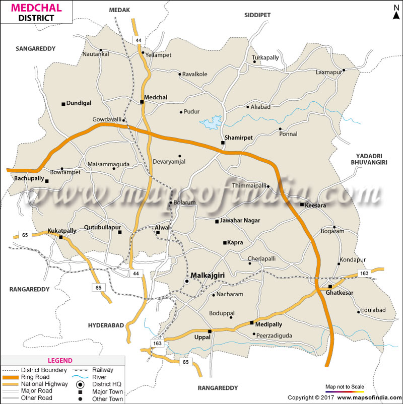
| *Medchal District Map highlights the National Highway, Major Roads, District Headquarter, etc in Medchal. |
| Districts of Telangana |
 |
 |
 |
 |
| Adilabad District Map | Nalgonda District Map | Mahbubnagar District Map | Medak District Map |
 |
 |
 |
 |
| Khammam District Map | Warangal District Map | Rangareddi District Map | Karimnagar District Map |
 |
 |
||
| Nizamabad District Map | Hyderabad District Map | ||
About
The warm winds of Telangana sweep across that ancient granitic boulder land that is the Deccan plateau and a sensational, irresistible jolt of modernity and traditionalism courses through the northern gateway of Hyderabad. Visiting the boundaries of a map of Medchal, you encounter a dizzying, fast-changing landscape with streets and roads turning suddenly into lakes, terrains and old caves. This vibrant and multifaceted administrative area occupies an area of approximately 1084 square kilometres around the northern borders of the state capital, as it connects technology zones with the farming heartland areas.
The colourful spectrum of this beautiful area includes picturesque water havens such as Shamirpet lake, very old heights of Keesara Gutta and the commercial hubs of Kukatpally, Quthbullapur and Uppal. This is the juxtaposition of speed and serenity, as hyper-modern elevated expressways fly by peaceful and lush grape orchards and millennia-old spiritual shrines.
The geographical spread in a Medchal district map shows character areas where there is opportunity for high-density development, as well as quiet ecological getaways. The plateau, rising some 505 metres above sea level, showcases dramatic natural environments, ranging from giant granite tors to some green areas of forest, with ancient royal reservoirs created under the Nizam’s period. From the hustle and bustle of Secunderabad's boulevards or from the rolling countryside of Medak and Siddipet, one is greeted by an energetic and sprawling part of the District that embodies the pulse of modern times in the State of Telangana.
History & Culture
Over such granitic outcrops, once thunderous cavalry charges and royal processions played out, marking millennia of dramatic political changes. This rich, fertile plateau was traversed by old trade routes, the earliest human settlements being founded under the protection of a monolithic stone hill in the early times. This was followed in subsequent golden ages by the great architectural and political style of the Kakatiyas, the Qutb Shahis and the Asaf Jahi Nizams.
On a careful study of a Medchal district map of the past, the traces of royal support will be found in old hunting lodges, fortified hill tops, majestic step-wells, etc., laid out in the land. For centuries, the Nizam rulers wove their well-appointed summer palaces in the shade of the trees, in the beautiful vineyards of Medchal. This splendid fight for Telangana's liberation and finally the historic reorganisation on 11 October 2016 established this unique administrative entity based on historic pride and future prospects.
The cultural vibrancy flows through all the neighbourhoods, and the ages-old Deccan tradition is seamlessly intertwined with cosmopolitanism as people from around the world come to work here. In Bonalu, women carry decorated brass pots as an offering to the Mother Goddess; celebrations are joyous in the streets, the beat of the rhythmic drumming is picked up by the crowds, and folk dancing is done full swing. On Bathukamma days, thousands of people converge along the shores of the lake to dedicate beautiful floral arrangements to nature, and produce kaleidoscopic rows of colours. The traditional Telugu dramas and classical music, festive Muslim celebrations on the occasion of Eid and the grand Jain pilgrimage enrich the richness of local identity through a history of living together in multicultural harmony.
Economy
The vast grey expanse under the dramatic backdrop of skyscrapers that rise from the landscape and the green rolling foothills is an economic giant that drives the state's financial engines. When looking at an industrial belt map of Medchal, it is evident that the area is a place of amazing intermingling of heavy industrial production, advanced biotechnology, logistics and growing services. The district with enormous potential for revenue earning and job creation, where the Medchal–Malkajgiri district of Telangana is both the most populous and most industrialised one.
Administrative bodies, district collectorate departments, urban development agencies such as the Hyderabad Metropolitan Development Authority (HMDA), and municipal corporations coordinate the planning and civil works for the community which are viewed as public. Public institutions create thousands of permanent jobs as they expand water pipes, arterial transportation networks, and educational facilities.
The Public Sector presents national laboratories and military technoparks, state-supported national technology parks, public banking networks and huge military factories across strategic areas that have been mapped on a Medchal district map. Thousands of manufacturing plants are located in key industrial centres such as Balanagar, Jeedimetla and Uppal, producing pharmaceuticals, precision engineering, electrical machinery, plastic processing, and consumer goods. An innovative policy called TSiPASS brought many new industrial businesses, investing millions of dollars throughout the district, which paved the way for tens of thousands of skilled manufacturing careers per district.
The export sector in the Services Sector is growing faster than all other sectors. A rich intellectual ecosystem provides the setting for world-class educational institutions such as BITS, Pilani – Hyderabad Campus and other leading engineering institutions, which attract the attention of global technology companies and research centres. The city is home to colourful business pockets with massive shopping malls, health mega-complexes, real estate developments and logistics. Meanwhile, every commercial corridor on a Medchal district map is witnessing high-value production of dairy products and organic produce from agricultural activities near the borders of the rural areas, proving that each and every one of the commercial corridors contributes to a versatile economic powerhouse.
Tourism
But there is no forced decision to be made between the many layers of Medchal, as it can be trekking through centuries of sacred tales, untouched natural areas, and dramatic amusement rides. Feathering the paths outlined on one of the Medchal district maps, one reaches the magnificent hill shrine of Keesara Gutta, ancient stone Swayambhu Lingams, 'Fort remains' and ‘Monolithic boulders' reverberate memories to early antiquity. The holy granite hill, dedicated to Lord Ramalingeswara, attracts a huge number of tourists during the occasion of Maha Shivaratri.
There are also many silent spiritual centres, like ISKCON Krishna-Balarama temple complex at Dabilpur, wherein gaushalas and organic farms exist, which enable quiet spiritual contemplation for spiritual seekers. Shamirpet Lake is a favourite weekend destination for the urbanites with its rocks, deer parks and peaceful waters that offer a dramatic sunset.
From runaway water parks, aimed at families and offering spectacular adventures, to the famous highway dhabas and restaurants which are great for food lovers, each destination listed on a Medchal district map is bound to be an adventure to remember. The modern Rajiv Gandhi International Cricket Stadium in Uppal is a regular venue for cricket enthusiasts, where international games spark passionate sportsmanship. Here, visitors can enjoy a feast for the soul, whether they are in awe of the prehistoric rock formations or their visit takes them through the quiet courtyard of one of the temples.
Demographics
Human geography of this rapidly changing land paints an inspiring picture of high urbanisation, outstanding literacy and rich cultural diversity. When the human density is observed for each and every district on the Medchal district map, according to official records, the most populated district in Telangana is Medchal, with more than 2.44 million human beings. The proportion of the total population is more than 91 per cent in urban areas, which is an incredible example of rapid modern urbanisation, second only to Hyderabad.
Social development indicators remain very high, with an overall literacy rate above 82 per cent—a population that grows increasingly progressive in terms of higher education, technicalities and professional business enterprises. The established sex ratio of 957 females to 1,000 males is also favourable, and there is good civic infrastructure to provide public health care and child development programs.
Telugu is the language that is widely used by nearly 80 per cent of the population, whilst Urdu, Hindi, Tamil, Marathi and English are widely spoken in commercial and residential areas. Reward the increase in ethnic and cultural diversity, as each commune marked on the Medchal district map shows the harmonious mix of diverse communities with native families alongside some that are tech-sector migrants. The mix of social types creates an atmosphere of acceptance, safety and a strong sense of civic pride.
Administration
Governance in this highly urbanised and rural area is carefully designed to enable fast public administration, development of infrastructure and ecological governance. On the Medchal district map showing administrative boundaries, the district is led and managed by the District Collector of Medchal, with the Admin Headquarters located at Shamirpet. There are 15 administrative mandals in the district, which are divided into two revenue divisions: Keesara and Malkajgiri.
A number of key urban and rural zones like Alwal, Bachupally, Balanagar, Dundigal, Gandimaisamma, Kukatpally, Medchal, Medipally, etc., are part of these mandals and include Shamirpet, Uppal, Keesara, Kapra, Ghatkesar, Quthbullapur and Muduchintalpalli. This is done through the 162 revenue villages, many municipal circles belonging to Greater Hyderabad Municipal Corporation (GHMC), and active panchayats in the villages.
Every administration, ranging from the municipalities and the village administrations in Jeedimetla and Vaniguda localities in the Medchal blocks, marked on a Medchal district map, is in cooperation with each other and serves civic functions, tiding, enforcement of law, surveillance and protection of the environment. This distributed management system ensures that through the application of technology, both urban and rural hamlet communities are served in a timely fashion with civic services, public services to health and infrastructure investment.
FAQs
Q1: What is the district headquarters?
Shamirpet is the district headquarters.
Q2: What is the total population?
The total population is 2,440,073 inhabitants.
Q3: How many mandals exist here?
There are 15 mandals.
Q4: What is the literacy rate?
The literacy rate is 82.49 per cent.
Q5: How many revenue villages exist?
There are 162 revenue villages.
Q6: What is the main official language?
Telugu is the main official language.
Q7: What makes the district famous?
It is famous for industries and temples.
Last Updated on : August 05, 2026
