Nirmal District Map (Telangana)


District Map of Nirmal (Telangana)

separator Click here for Customized Maps arrow custom map
District Map of Nirmal MAHARASHTRA Adilabad Komaram Bheem Mancherial Jagtial Nizamabad
Print Email Save Buy Now 
*Nirmal District Map highlights the National Highway, Major Roads, District Headquarter, etc in Nirmal. Disclaimer


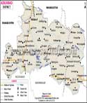
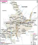
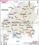
Nirmal District Fact Sheet
DistrictNirmal
HeadquartersNirmal town
Population as per 2011 Census709418
Area (Sq. Kms.)3845
Density of Population (per Sq. Km.)185
Literates57.77
Forest Cover (Sq. Kms.) 1213.08
Languages OfficialTelugu, Urdu
TempleSri Gnana Saraswathi Temple
MandalsNirmal Rural, Soan, Dilawarpur, Narsapur G, Kaddam Peddur, Dasturabad, Khanapur, Mamada, Pembi, Laxmanchanda, Sarangapur, Kubeer, Kuntala, Bhainsa, Mudhole, Basar, Lokeshwaram, Tanoor


Source :-http://nirmal.telangana.gov.in/
www.trac.telangana.gov.in
  Districts of Telangana  
Adilabad District Map Nalgonda District Map Mahbubnagar District Map Medak District Map
Adilabad District MapNalgonda District MapMahbubnagar District MapMedak District Map
    
Khammam District Map Warangal District Map Rangareddi District Map Karimnagar District Map
Khammam District MapWarangal District MapRangareddi District MapKarimnagar District Map
Nizamabad District Map Hyderabad District Map
Nizamabad District MapHyderabad District Map


Last Updated on : March 16, 2017