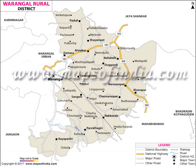
Warangal Rural District Map, Telangana |
|
||||||||||
 | ||||||||||
|





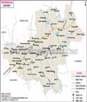
| *Warangal Rural District Map highlights the National Highway, Major Roads, District Headquarter, etc in Warangal Rural. |
| Districts of Telangana |
 |
 |
 |
 |
| Adilabad District Map | Nalgonda District Map | Mahbubnagar District Map | Medak District Map |
 |
 |
 |
 |
| Khammam District Map | Warangal District Map | Rangareddi District Map | Karimnagar District Map |
 |
 |
||
| Nizamabad District Map | Hyderabad District Map | ||
About
Warangal is one of the oldest cultural towns of Telangana with a rich and unique heritage. It can rightfully be the pride defender of the state that the town is essentially the face of the local people's heritage and identity which are reflected through it. This town lies in the northern part of Telangana and is approximately 148 km Northeast of Hyderabad, the capital city of the state. This city is surrounded by tall forests which is why Warangal stands out as a city of a very pleasant and cool climate. In a sense, some say this city is located in the dry part of the Deccan Plateau. The town name today, "Warangal", has developed from a confluence of the two names "Orugallu" and "Guttagutta". Orugallu means "one + stone". "Guttagutta" literally translates to a "rock town". These names clearly point to that huge solid rock formation which today houses the fort Hill at Warangal (Govinda Rajula Gutta) - around which the original town and fort were built back in the Kakatiya times. Warangal district is mostly covered with rolling terrains that are of granitic plateau types, huge agricultural land, and large forest cover in their eastern belts. It has been recognized nation-wise as an educational, cultural, and economic hub where a lot of historic buildings stand alongside an ever-growing commercial sector and a large network of schools and educational Institutions. Warangal has also qualified for India's Smart Mission.
History & Culture
Kakatiya Golden Age: During their rule, the Kakatiya Dynasty gave rise to the most unforgettable era for Warangal. It was at the behest of King Rudradeva that the kingdom’s headquarters was moved from Hanamkonda to Warangal - a city that turned into a stunning center. The Ganapati Deva was instrumental in the extension of the kingdom's territory. He also laid the foundation for international maritime trade and initiated the building of the sturdy Warangal Fort. Rani Rudrama Devi was one of India's very few female rulers and is known for excellent military tactics, defending the kingdom from external threats, and working on citizen welfare schemes. Prataparudra was the last great Kakatiya ruler. He developed and modernised the country's defenses before it ended up as a possession of the Delhi Sultanate by the hands of Alauddin Khalji's Malik Kafur in 1323 CE.
Architecture
Warangal is internationally known for the remarkable Kakatiya architecture style, which features detailed stone carving, large one-piece gateways (Kala Thoranams), spinning polished rock pillars, and strong foundation system techniques.
Events & Festivals
One of the biggest meetings of tribesmen all over the world, Sammakka-Sarakka Jatra is held once every two years at Medaram, a place that was once part of the region of Warangal. Its enormity and vivid colors can be taken at a glance and one's mind would say that it is definitely more than a festival. Millions upon millions of devotees flock to it from various parts of the world. Bathukamma: This is a flower festival of Telangana. Women take part in this celebration with great enthusiasm and using the wildflowers indigenous the the region they create concentric layers. Bonal: This is an ancient festival that reveres the Goddess Mahakali.
Economy
Warangal serves as the chief financial and trading hub for northern and eastern Telangana. Its business is supported by farming, the presence of the Government, modern services, and the manufacturing of cotton textiles and other fabrics.
Public & Government Sector
Railways: A big South Central Railway station, engine repair center, and storage point. The railway works here at wagon repair shops and in railway operations provide jobs to tens of thousands of workers. There are several Government higher education institutions in Warangal, like the National Institute of Technology, Kakatiya University, Kakatiya Medical College, etc. The existence of these establishments has resulted in massive government spending on research, innovation, and job creation. Rajdhani and other offices: Government departments, district judiciary and municipal authorities together constitute a large part of the formal work sector providing stable jobs.
Industrial & Private Sector
Textile & Weaving: Besides being a major brassware-producing center, and also for durries (traditional rugs) and floor carpets in cotton, the carpet weaving craft of Warangal has gained global recognition as an important handicraft product. Warangal Kakatiya Mega Textile Park (KMTP): By developing this park named Kakatiya, after an old dynasty that ruled Andhra Pradesh for more than 200 years, the town of Warangal aims for the top level. The park has facilities so excellent that only top domestic and global textile companies will probably come there, build their plants, and manufacture in the textile area.
Information Technology (IT): The state government, after thoroughly analyzing the situation at hand through different parameters of potential and growth, has classified Warangal city as a Tier-II city. There is currently a significant number, both active and passive, of IT offices and tech businesses in and around the area.
Services Sector
Hub for Healthcare: This city is the main medical center serving the countryside, supported mainly by government hospitals and private multi-specialty medical centers. Retailers, hospitality industries and banking services have all developed alongside the fast urban growth to serve students, tourists and the growing middle class with their services.
Tourism
Historical Monuments & Architecture
Warangal Fort: Constructed in the 13th century during the reign of King Gannapati Deva and Rani Rudrama Devi, the fort has a remarkable feature of three successive ring-shaped defenses. Inside, the central area consists of the remnants of the famous Kakatiya Kala Thoranams, four big gateway structures made of granites with fine carvings that have come to represent Telangana's identity. Tenkasi Temple At Hanamakonda, about 12 miles from Warangal, stands the temple that is regarded as one of the finest architectural specimen of this region, built in the 12th century built by King Rudrama Devi as a temple for the Sun god. The architecture of the structure has a star shape. As a place of worship, it is the abode of the three divine forms- Shiva, Vishnu, and the sun deity. There are pillars made of rotated basalt stone. Nandi is a single stone statue with a lot of features, and it is located at the feet of the Lord in all the temples. Nandi bull statues and pillars made of rotated basalt, all of which are parts of rock-cut architecture, are placed together and carved out of one and the same stone. Museum of Warangal Fort: Inside the premises of Warangal Fort, there is a museum exhibiting numerous historical artifacts. It includes weapons made of metals and those of stone as well. Many stone weapons are found besides iron weapons, such as a spear sword arrows spearheads etc. Some weapons are of bronze too. And weapons, different types of metal pieces used in everyday life are kept like coins, rings, and brooches. This museum is actually one among the richest in India. Ramappa Temple (Kakatiya Rudreshwara Temple) at Palampet which is situated very close to the district border this place is a UNESCO World Heritage Site apart from it one of the chief architectural marvels to witness there. General Recharla Rudra started its construction in 1213 CE it is famous for floating lightweight stone masonry work, dolerite stone sculptures with engravings and the dancing figure supports (koris). Khush Mahal
Not far from the Warangal Fort lies an audience hall which is a piece of either Tughlaq or Bahmani rulers of the 14th century showing a distinct Indo-Islamic style of arches.
Natural Attractions & Eco-Tourism
Pakhal Lake and Jungle Sanctuary - Constructed in 1213 CE by the Kakatiya Kings, this reservoir has created a vast wild home to animals of a size of about 30 sq. km. Dense deciduous forest and low hills are a good natural cover. It is the habitat of leopard, sloth bear, chital, and various migratory birds. Laknavaram Lake: It has thirteen green islands with a beautiful suspension bridge and a large waterscape
Demographics
Demographic numbers and figures are compiled using data from official Indian Census as well as recent administrative projections. General population: the joint district was at 917,641 in 2011 (Census of India). Talking about literacy, the district average is at 65.11%. Meanwhile, the urban literacy rate has quite a bit surpassed the former by almost 17 to 18% as educational institutions are densely located there. District/Urban - Male literacy: ~74.58% / ~90.39%. District/Urban - Female literacy: ~55.69% / ~76.22%. Sex Ratio: 997 females per 1,000 males; the number is relatively higher when compared against the nation's sex ratio. Languages: Across population groups of all ages and all regions, the dominant language isTelugu which is both an official and spoken language. The urban Muslims are the speakers of the Urdu language, and English and Hindi are the working languages in commerce, higher education, and administration.
Administration
Administratively divisions of revenue consist of the main divisions separated into Mandals (Tehsils) for local governance and developmental outreach: Total Revenue Villages: This part of the area is spread across rural and semi-urban mandals and at the moment consists of more than 180 revenue villages only. Warangal Administration: The City's administrative units have joined forces under the name "The Greater Warangal Municipal Corporation (GWMC)". The GWMC has a total of 66 wards that provide different services from developing infrastructure to sanitation, water supply, city planning and regulating developments in the city etc.
| Facts of Warangal District | |
|---|---|
| Official Name | Warangal |
| Location | Telangana |
| Area (km2) | 1765 |
| Population | 917,641(2011) |
| Language | Telugu, Urdu |
FAQs
Q1: What is the population of Warangal district?
The district has a population of 917,641 people as per 2011.
Q2: How many villages are in Warangal district?
It has 190 inhabited villages.
Q3: What is the literacy rate of Warangal district?
The literacy rate is 65.11% .
Q4: Which language is mainly spoken in Warangal district?
Telugu is the main spoken language.
Q5: What is Warangal district famous for?
It is recognized as an important hub of education with NIT Warangal among its institutions, famous for the chilli market at.
Q6: What significance does the moniker "Tri-City" hold about Warangal?
The Tri-City district, comprising the conure of Warangal, Hanamkonda, and Kazipet, forms the second-largest urban agglomeration of the state of Telangana.
Q7: Why is Warangal called the educational hub of Telangana?
Due to a number of established academic institutions and research organizations, Warangal is deemed to be an educational hub.
Q8: What is the Kakatiya Kala Thoranam?
The Kakatiya Kala Thoranam is also known as Warangal Gate.
Q9: How is Warangal linked to Telangana's agriculturally driven economy?
Warangal is a significant and thriving contributor to the commercial sector in South India and is regarded as the most prolific region in India for the production of superior quality boll cotton and red hot chillies.
Q10: Which flagship programs include Warangal as a part?
Warangal features as a part of two flagship urban development Programs in India:HRIDAY (Heritage City Development and Augmentation Yojana).
Last Updated on : August 05, 2026
