India is a very big country and it houses different types of forests. These forests include protected forests or reserved forests. Prior to the independence of the country, the forests of the country were protected under the Indian Forest Act, of 1927.
Following the freedom of the country, the Indian Government has preserved the status of the prevailing protected and reserved forests of the country.
The protected forests of India can be broadly categorized into two types - undemarcated protected forests and demarcated protected forests. and this categorization has been made on whether the boundaries of the forest have been delineated by an official declaration.
The abundant and varied flora and fauna of India are housed in 13 biosphere reserves, 89 national parks, and more than 400 wildlife sanctuaries located throughout the nation.
The different types of forests of India are classified below:
- Tropical rainforests
- Temperate deciduous forests
- Himalayan subtropical pine forests
- Indian tidal or mangrove forests
- Indian dry deciduous forests
- Humid deciduous forests of the •Eastern Highlands
- Mountain Forests
- Tidal forests
- Dry evergreen forests of the East •Deccan Region
- Monsoon forests
Tropical Evergreen forests
Tropical evergreen rain forests are found in areas where rainfall exceeds 200 cm. They are commonly found in Arunachal Pradesh, Meghalaya, Assam, Nagaland, Western Ghats, foothills of Himalayas, Andaman Islands and northeastern regions. They are also found in the hills of Khasi and Jayanti. The trees in this area grow rapidly.
Temperate deciduous forests
This type of forest is found in cold climates. Coniferous trees are found in temperate forests. Deodar, pine, etc. trees are found in these types of forests. Trees of temperate forests are broad-leafed. Snow does not stay on the leaves of these trees. For this reason, the texture of the leaves of these trees is different. Alpine is one type of temperate forest.
Dry Deciduous Forests
These forests grow in areas where rainfall is between 50 cm and 100 cm. They are mainly seen in the central Deccan plateau, Punjab, Haryana, Uttar Pradesh, Madhya Pradesh and parts of south-east Rajasthan.
Mountain Forests
Variation is found in mountain forests along the slopes of the mountain. Evergreen trees like teak and bamboo grow in abundance from an altitude of 1500 meters to the foothills of the Himalayas.
On higher slopes, temperate coniferous trees such as pine and oak trees grow. At the height of the Himalayas, rhododendrons and junipers are found. In comparison to these vegetated areas, alpine meadows are visible up to the snowfield.
Tidal or Mangrove Forests
Mangroves or tidal forests grow along the coast and the edges of deltas, such as the Cauvery, Krishna, Mahanadi, Godavari, and Ganges deltas. In West Bengal, these forests are known as 'Sunderbans'. Sundari is the biggest tree in these forests.
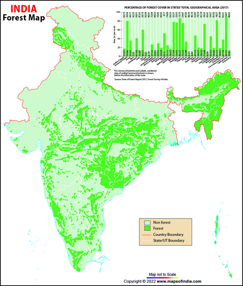
The total forest cover in India is 21.71% of the geographical area. The tree cover is nearly 2.91% of the geographical area. Thus, the total forest and tree cover is 24.62% geographical area of the country.
Approximately 20% of the overall forest cover of India is located in the state of Madhya Pradesh. States like Maharashtra, Orissa, Andhra Pradesh, Uttar Pradesh, and Arunachal Pradesh also house a considerable volume of forests.
The second biggest land use in the country after farming is forests. Forests encompass 67.83 million hectares of area in India which represents 20.64% of the nation's geographical territory, varying from the arid zone forests to Himalayan temperate forests.
| State Wise summary of Forest Cover in hill districts | (Area in sq km) | ||||||||
|---|---|---|---|---|---|---|---|---|---|
| STATE | NO. of Hill Districts | Geographical Area | 2017 Assessment | % of GA | Change | Scrub | |||
| VDF | MDF | OF | TOTAL | ||||||
| Arunachal Pradesh | 16 | 83743 | 20721 | 30955 | 15288 | 66964 | 79.96 | -190 | 247 |
| Assam | 3 | 19295 | 845 | 5683 | 6575 | 13103 | 67.91 | 100 | 89 |
| Himachal Pradesh | 12 | 55673 | 3110 | 6705 | 5285 | 15100 | 27.12 | 393 | 308 |
| Jammu & Kashmir | (a)14 | 101388 | 2728 | 6119 | 7165 | 16012 | 15.79 | 8 | 238 |
| (b)* | 120848 | 1347 | 2460 | 3422 | 7229 | 5.98 | 245 | 335 | |
| Karnataka | 6 | 48353 | 3912 | 14941 | 4831 | 23684 | 48.98 | 334 | 792 |
| Kerala | 10 | 29552 | 1308 | 7166 | 7830 | 16304 | 55.17 | 956 | 22 |
| Maharashtra | 7 | 69905 | 315 | 7246 | 8059 | 15620 | 22.34 | 47 | 1415 |
| Manipur | 9 | 22327 | 908 | 6510 | 9928 | 17346 | 77.69 | 263 | 1111 |
| Meghalaya | 7 | 22429 | 453 | 9386 | 7307 | 17146 | 76.45 | -116 | 505 |
| Mizoram | 8 | 21081 | 131 | 5861 | 12194 | 18186 | 86.27 | -531 | 0 |
| Nagaland | 8 | 16579 | 1279 | 4587 | 6623 | 12489 | 75.33 | -450 | 503 |
| Sikkim | 4 | 7096 | 1081 | 1575 | 688 | 3344 | 47.13 | -9 | 307 |
| Tamil Nadu | 5 | 19384 | 1487 | 2614 | 2448 | 6549 | 33.79 | -144 | 61 |
| Tripura | 4 | 10486 | 656 | 5246 | 1824 | 7726 | 73.68 | -164 | 15 |
| Uttrakhand | 13 | 53483 | 4969 | 12884 | 6442 | 24295 | 45.43 | 23 | 383 |
| West Bengal | 1 | 3149 | 722 | 648 | 995 | 2365 | 75.1 | -11 | 10 |
| Grand Total | 113 | 704771 | 45972 | 130586 | 106904 | 283462 | 37.43 | 754 | 6341 |
*Includes Jammu & Kashmir area outside LOC that is under illegal occupation of Pakistan and China.
| Abstract of Forest Cover in tribal districts | (Area in sq km) | ||||||||
|---|---|---|---|---|---|---|---|---|---|
| State/UTs | No. of Tribal District | Geographical Area | 2017 Assessment | % of GA | Change | Scrub | |||
| VDF | MDF | OF | TOTAL | ||||||
| Andhra Pradesh | 5 | 44849 | 1510 | 5512 | 4396 | 11418 | 25.46 | 572 | 3078 |
| Arunachal Pradesh | 16 | 83743 | 20721 | 30955 | 15288 | 66964 | 79.96 | -190 | 247 |
| Assam | 19 | 49489 | 1513 | 3562 | 6757 | 11832 | 23.91 | 260 | 69 |
| Chhattisgarh | 11 | 92645 | 6509 | 21902 | 11539 | 39950 | 43.12 | -12 | 288 |
| Gujarat | 9 | 49885 | 324 | 2971 | 3671 | 6966 | 13.96 | 3 | 608 |
| Himachal Pradesh | 3 | 26764 | 869 | 1283 | 1107 | 3259 | 12.18 | 18 | 116 |
| Jharkhand | 17 | 58677 | 1869 | 7254 | 8296 | 17419 | 29.69 | 22 | 522 |
| Karnataka | 5 | 26054 | 2596 | 7437 | 3246 | 13279 | 50.97 | 156 | 109 |
| Kerala | 9 | 27207 | 1237 | 6756 | 6827 | 14820 | 54.47 | 523 | 22 |
| Madhya Pradesh* | 24 | 152132 | 5937 | 22096 | 19381 | 47414 | 31.17 | 118 | 2352 |
| Maharashtra | 12 | 144233 | 7229 | 11695 | 11613 | 30537 | 21.17 | -105 | 2177 |
| Manipur | 9 | 22327 | 908 | 6510 | 9928 | 17346 | 77.69 | 263 | 1111 |
| Meghalaya | 7 | 22429 | 453 | 9386 | 7307 | 17146 | 76.45 | -116 | 505 |
| Mizoram | 8 | 21081 | 131 | 5861 | 12194 | 18186 | 86.27 | -531 | 0 |
| Nagaland | 8 | 16579 | 1279 | 4587 | 6623 | 12489 | 75.33 | -450 | 503 |
| Orissa | 12 | 86091 | 5114 | 14275 | 14817 | 34206 | 39.73 | 415 | 2655 |
| Rajasthan | 5 | 29601 | 0 | 2156 | 3118 | 5274 | 17.82 | 24 | 634 |
| Sikkim | 4 | 7096 | 1081 | 1575 | 688 | 3344 | 47.13 | -9 | 307 |
| Tamil Nadu | 6 | 25607 | 853 | 2771 | 2076 | 5700 | 22.26 | 129 | 181 |
| Telangana | 3 | 42217 | 1187 | 6890 | 4962 | 13039 | 30.89 | -830 | 397 |
| Tripura | 4 | 10486 | 656 | 5246 | 1824 | 7726 | 73.68 | -164 | 15 |
| Uttar Pradesh | 1 | 7680 | 805 | 158 | 311 | 1274 | 16.59 | -24 | 4 |
| West Bengal | 12 | 69403 | 2980 | 3707 | 7908 | 14595 | 21.03 | 22 | 136 |
| A & N Islands | 3 | 8249 | 5678 | 684 | 380 | 6742 | 81.73 | -9 | 1 |
| Dadra & Nagar Haveli | 1 | 491 | 0 | 80 | 127 | 207 | 42.16 | 1 | 5 |
| Darnan & Diu | 1 | 72 | 0 | 2.04 | 8.92 | 10.96 | 15.22 | 0.85 | 0.27 |
| Lakshadweep | 1 | 30 | 0 | 17.04 | 10.06 | 27.1 | 90.34 | 0.04 | 0 |
| Grand Total | 215 | 1125117 | 71439 | 185328.08 | 164402.98 | 421170.06 | 37.43 | 86.89 | 16042.27 |
*Forest Area Within Tribal Districts in Madhya Pradesh was inadvertantly shown as 77462 sq km in IFSR 2015 which may be read as 42191 sq km.
| Forest Cover in North -Eastern States | (Area in sq km) | ||||||||||
|---|---|---|---|---|---|---|---|---|---|---|---|
| State | Geographical Area | 2017 Assessment | Change | Scrub | |||||||
| VDF | %VDF | MDF | %MDF | OF | %OF | TOTAL | % Forest to GA | ||||
| Arunachal Pradesh | 83743 | 20721 | 30.94 | 30955 | 46.23 | 15288 | 22.83 | 66964 | 79.96 | -190 | 247 |
| Assam | 78438 | 2797 | 9.95 | 10192 | 36.26 | 15116 | 53.78 | 28105 | 35.83 | 567 | 217 |
| Manipur | 22327 | 908 | 5.23 | 6510 | 37.53 | 9928 | 57.24 | 17346 | 77.69 | 263 | 1111 |
| Meghalaya | 22429 | 453 | 2.64 | 9386 | 54.74 | 7307 | 42.62 | 17146 | 76.45 | -116 | 505 |
| Mizoram | 21081 | 131 | 0.72 | 5861 | 32.23 | 12194 | 67.05 | 18186 | 86.27 | -531 | 0 |
| Nagaland | 16579 | 1279 | 10.24 | 4587 | 36.73 | 6623 | 53.03 | 12489 | 75.33 | -450 | 503 |
| Sikkim | 7096 | 1081 | 32.33 | 1575 | 47.1 | 688 | 20.57 | 3344 | 47.13 | -9 | 307 |
| Tripura | 10486 | 656 | 8.49 | 5246 | 67.9 | 1824 | 23.61 | 7726 | 73.68 | -164 | 15 |
| Total | 262179 | 28026 | 74312 | 68968 | 40.26 | 171306 | 65.34 | -630 | 2905 | ||
| Forest Cover in Altitude Zones | (Area in sq km) | |||||||
|---|---|---|---|---|---|---|---|---|
| Altitude Zone | Goe.Area | VDF | MDF | Open | Total Forest Cover | Percent Total FC | Percent of GA of zone | Change w.r.t IFSR 2015 (updated) |
| 0-500m | 2329321 | 39049 | 150794 | 185146 | 374989 | 52.94 | 16.1 | 7087 |
| 500-1000m | 541747 | 25493 | 95178 | 77787 | 198458 | 28.02 | 36.63 | 276 |
| 1000-2000m | 117835 | 15267 | 35979 | 25056 | 76302 | 10.77 | 64.75 | -217 |
| 2000-3000m | 56891 | 14740 | 18569 | 7218 | 40527 | 5.72 | 71.24 | -193 |
| 3000-4000m | 62405 | 3555 | 7554 | 6100 | 17209 | 2.43 | 27.58 | -76 |
| Above 4000m | 179270 | 54 | 244 | 490 | 788 | 0.11 | 0.44 | -99 |
| TOTAL | 3287469 | 98158 | 308318 | 301797 | 708273 | 99.99 | 21.54 | 6778 |
| State/ UT wise extent of water bodies | (Area in sq km) | |||
|---|---|---|---|---|
| S.NO | State | Extent of water bodies 2005 | Extent of water bodies 2015 | Change |
| 1 | Andhra Pradesh | 626 | 943 | 317 |
| 2 | Arunachal Pradesh | 582 | 387 | -195 |
| 3 | Assam | 387 | 474 | 87 |
| 4 | Bihar | 52 | 44 | -8 |
| 5 | Chhattisgarh | 850 | 927 | 77 |
| 6 | Delhi | 3.77 | 4.32 | 0.55 |
| 7 | Goa | 76 | 84 | 8 |
| 8 | Gujarat | 2203 | 2631 | 428 |
| 9 | Haryana | 21 | 16 | -5 |
| 10 | HImachal Pradesh | 402 | 455 | 53 |
| 11 | Jammu & Kashmir | 267 | 287 | 20 |
| 12 | Jharkhand | 147 | 211 | 64 |
| 13 | Karnataka | 1493 | 1620 | 127 |
| 14 | Kerala | 302 | 373 | 71 |
| 15 | Madhya Pradesh | 1930 | 2319 | 389 |
| 16 | Maharashtra | 1116 | 1548 | 432 |
| 17 | Manipur | 32 | 58 | 26 |
| 18 | Meghalaya | 105 | 142 | 37 |
| 19 | Mizoram | 72 | 124 | 52 |
| 20 | Nagaland | 39.43 | 62.8 | 23.37 |
| 21 | Odisha | 312 | 369 | 57 |
| 22 | Punjab | 30 | 37 | 7 |
| 23 | Rajasthan | 414 | 454 | 40 |
| 24 | Sikkim | 10 | 12 | 2 |
| 25 | Tamil Nadu | 453 | 732 | 279 |
| 26 | Telangana | 871 | 1228 | 357 |
| 27 | Tripura | 77 | 113 | 36 |
| 28 | Uttar Pradesh | 1220 | 1018 | -202 |
| 29 | Uttrakhand | 310 | 355 | 45 |
| 30 | West Bengal | 82 | 104 | 22 |
| 31 | A & N Islands | 2.84 | 2.41 | -0.43 |
| 32 | Chandigarh | 1.45 | 1.49 | 0.04 |
| 33 | Dadra & Nagar Haveli | 17.34 | 17.44 | 0.1 |
| 34 | Daman & Diu | 2.08 | 2.71 | 0.63 |
| 35 | Lakshadweep | 0 | 0 | 0 |
| 36 | Puduchery | 0 | 0 | 0 |
| TOTAL | 14508.91 | 17156.17 | 2647.26 | |
| Error matrix | |||||||
|---|---|---|---|---|---|---|---|
| Classification classes | Ground Truth(based on field inventory data) | User's Accuracy(%) | |||||
| VDF | MDF | OF | SCRUB | NF | TOTAL | ||
| VDF | 200 | 5 | 9 | 2 | 2 | 218 | 91.74 |
| MDF | 11 | 1075 | 60 | 10 | 18 | 1174 | 91.57 |
| OF | 15 | 56 | 1237 | 7 | 29 | 1344 | 92.04 |
| SCRUB | 0 | 4 | 5 | 86 | 2 | 97 | 88.66 |
| NF | 17 | 42 | 103 | 9 | 1148 | 1319 | 87.04 |
| Total | 243 | 1182 | 1414 | 114 | 1199 | 4152 | |
| Producer's Accuracy(%) | 82.3 | 90.95 | 87.48 | 75.44 | 95.75 | ||
| Overall Accuracy | 90.00% | ||||||
| Overall Kappa Statistics | 0.86 | ||||||
| Simplified Error matrix | ||||
|---|---|---|---|---|
| Classification classes | Ground Truth(based on field inventory data) | User's Accuracy(%) | ||
| Forest | Non-Forest | Total | ||
| Forest | 2668 | 68 | 2736 | 97.51 |
| Non-Forest | 171 | 1245 | 1416 | 87.92 |
| Total | 2839 | 1313 | 4152 | |
| Producer's Accuracy(%) | 93.98 | 94.82 | ||
| Overall Accuracy | 94.24% | |||
| Overall Kappa Statistics | 0.87 | |||
| National Level Forest Cover Information in different patch sizes | |||||
|---|---|---|---|---|---|
| SI.NO | Patch Size Range in(sq.km) | No. of Patches | Forest Cover | Percentage | |
| 1 | >=0.01 | < =1.0 | 727380 | 54082 | 7.64 |
| 2 | >1.0 | < =10 | 16444 | 43639 | 6.16 |
| 3 | >10 | < =100 | 2183 | 58052 | 8.2 |
| 4 | >100 | < =500 | 257 | 51298 | 7.24 |
| 5 | >500 | < =1000 | 57 | 39628 | 5.59 |
| 6 | >1000 | < =5000 | 42 | 85407 | 12.06 |
| 7 | >5000 | < =10000 | 14 | 90028 | 12.71 |
| 8 | >10000 | 9 | 286139 | 40.4 | |
| TOTAL | 746386 | 708273 | 100 | ||
Last Updated on : April 17, 2026