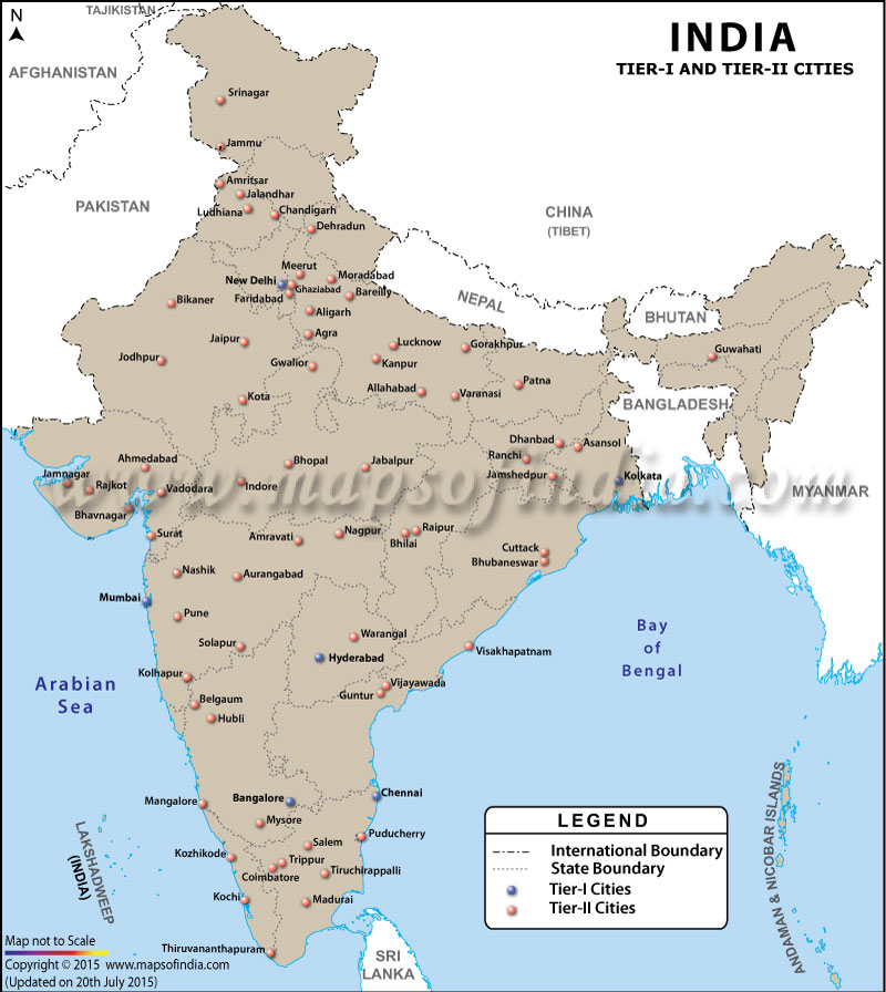
Classification of Indian Cities
| States/UTs | Cities Classified as "X" (Tier-I) | Cities Classified as "Y" (Tier-II) |
|---|---|---|
| Andhra Pradesh | Hyderabad | Vijayawada, Warangal, Vishapatnam, Guntur |
| Assam | Guwahati | |
| Bihar | Patna | |
| Chandigarh | Chandigarh | |
| Chhattisgarh | Durg-Bhilai, Raipur | |
| Delhi | Delhi | |
| Gujarat | Ahmedabad, Rajkot, Jamnagar, Vadodara, Surat | |
| Haryana | Faridabad | |
| Jammu and Kashmir | Srinagar, Jammu | |
| Jharkhand | Jamshedpur, Dhanbad, Ranchi | |
| Karnataka | Bengaluru | Belgaum, Hubli-Dhanbad, Mangalore, Mysore |
| Kerala | Kozhikode, Kochi, Thiruvanathpuram | |
| Madhya Pradesh | Gwalior, Indore, Bhopal, Jabalpur | |
| Maharashtra | Mumbai | Amravati, Nagpur, Aurangabad, Nashik, Bhiwandi, Pune, Solapur, Kolhapur |
| Orissa | Cuttack, Bhubaneswar | |
| Punjab | Amritsar, Jalandhar, Ludhina | |
| Pondicherry | Pondicherry | |
| Rajasthan | Bikaner, Jaipur, Jodhpur, Kota | |
| Tamil Nadu | Chennai | Salem, Tiruppur, Coimbatore, Tiruchirappalli, Madurai |
| Uttar Pradesh | Moradabad, Meerut, Ghaziabad, Aligarh, Agra, Bareilly, Lucknow, Kanpur, Allahabad, Gorakhpur, Varanasi | |
| Uttarakhand | Dehradun | |
| West Bengal | Kolkata | Asansol |
Tier I, II, III Cities of India
The cities in India are categorised on the basis of a grading structure devised by the Government of India. This system helps the authorities to allot House Rent Allowance (HRA) to the employees of the public sector, posted in different cities across the country.
Following the recommendations of the Sixth Central Pay Commission of 2008, the cities are categorised under sections X, Y and Z. The Union Cabinet of India had established the 6th CPC on 5 October 2006 with the objective to edit and hike up the salaries of the public servants, serving the central government.
Formerly, the division was made on the grounds of Compensatory City Allowance (CCA) and HRA. However, after CPC 2008, the population of the city has been set as the criteria for the segregation. As per the changes, A-1 has been renamed as X, while A, B-1 & B-2 as Y, and C & uncategorised cities as Z. The better known term for the categories is Tier-I, Tier-II and Tier-III cities, respectively.
As per media reports, there are about 8 Tier I cities, 26 Tier II cities, 33 Tier III cities and over 5,000 Tier IV towns, while there are more than 638,000 villages in the country.
WBMA100714
General Maps
- National Science Museums in India
- Jyotirlinga Shrines
- Geological Map of India
- Canals in India
- Major Lakes in India
- Heritage Map of India
- Pin Code Zones in India
- Per Capita Income of India
- Major Sea Ports
- Languages in India
- Climate map of India
- Parlimentary Constituencies in India
- Tourist Circuits in India
- Metallic Minerals in India
- Cold Desert Map
- Major Electricity Generator Plants
- Religions In India
- Major Earthquakes in India
- Major Hydro Power Plants
- Indian States and Union Territories
- Cabinet Ministers
- Map of Indian States and Union Territories Enlarged View
- Physiographic Map of India
- Religious Places in India
- Geographical Map of India
- Dams in India
- India Coal Reserves Map
- India Political Map Enlarged View
- India Satellite Map
- Topographic Map of India
- Population Map Of India
- Natural Hazard Map of India
- Tourist Map of India Enlarged View
- Tier I and Tier II Cities of India
- Cyclone Prone Areas in India
- Outline Map of India Enlarged View
- Wine Producing Regions in India
- Map of Major Airports in India
- Birth Rate in India
- Statehood Movements in India
Last Updated on : April 17, 2026