| |
Major Districts of Kerala |
|
 |
 |
 |
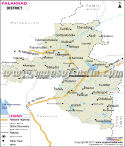 |
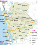
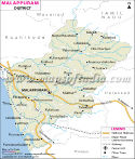
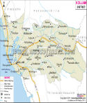
| Ernakulam District Map | Malappuram District Map | Kollam District Map | Palakkad District Map |
| | | | |
 |
 |
 |
 |
| Kannur District Map | Thiruvananthapuram District Map | Kottayam District Map | Kozhikode District Map |
| | | | other districts of Kerala >> |
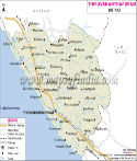
The potential of the district of Kannur as a tourist spot is very high compared to the other districts of
Kerala.
Kannur lies within 11° 40' and 12° 48' North latitudes and 74° 52' and 76° 07' East longitudes with a total area of 2,966 square kilometers. The total population of this district is 22,51,727 of which the number of males are 10,98,838 and number of females are 11,52,889.
The economy of
Kannur is dependent on agricultural products. Coffee, rubber and tea form the primary plantations. Timber is also abundant in this district.
Some of the important tourist sites are-
- Fort St. Angelos
- Thalassery Fort
- Payyambalam Beach Resort
- Muzhappilangad Beach
- Malayalakalagramam
- Moppila Bay
Places in Kannur
Pulingome, Kozhichal, Cherupuzha, Peringom, Karthikapuram, Kokkanisseri, Payyannur, Ellmtara, Talipparamba, Payangadi, Srikandapuram, Vayathu, Kannapuram, Mattol, Cherukunnu, Pappinisseri, Valapattanam, Azhikkod, Chirakkal, Kannur, Muzhapilangadu, Edakkad, Dharmadam, Thalassery, Moderi, Kottayam, Kalavallur, Kottayam, Kattuparamba, Kannavam, Peravur, Muzhakunnu, Mattanur, Chavasseri, Iritti, Aralam, Kappad
Last Updated on : May 11, 2026
