| |
Major Districts of Kerala |
|
 |
 |
 |
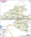 |
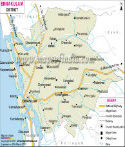
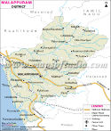
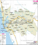
| Ernakulam District Map | Malappuram District Map | Kollam District Map | Palakkad District Map |
| | | | |
 |
 |
 |
 |
| Kannur District Map | Thiruvananthapuram District Map | Kottayam District Map | Kozhikode District Map |
| | | | other districts of Kerala >> |
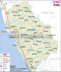
Palakkad lies in the eastern part of the state of
Kerala. It is a district abundant in natural beauty and thus is a center of attraction for the tourists.
Palakkad is situated within the latitudes stretching from 10° 21' to11° 14' north and longitudes stretching from 76° 02' to 76° 45' east.
The total population of the district according to the census of 2001 is 26,17,072. The number of male is 12,65,794 where as the number of female is 13,51,278. The area of Palakkad district is 4,480 sq km.
Rice is produced in an abundant quantity in Palakkad. Cotton, ragi, pepper, sugarcane and others are also produced here.
The tourists spots of Palakkad are-
- Kanhirapuzha
- Mangalam Dam
- Pothundy Dam
- Jain Temple of Jainmedu
- Thiruvalathoor
- Chittur Gurumadam
- Mayilladumpara-Cholanoor Peacock Sanctuary
Places in Palakkad Map
Attappadi, Edathanattakara, Thenkara, Alanallur, Mannaarkkad, Pattivasal, Seruvani Estate, Silent Valley, Karimpuza, Karalmanna, Srikrishnapuram, Peradiyur, Cheruppulasseri, Vallappula, Pattambi, Tritalla, Ottappalam, Palakkad, Shoranur, Challisseri, Kulamannam, Alattur, Peruvemba, Chittur, Tattamangalam, Pudunagaram, Kollegod, Kilakkettara, Nemmara, Vedakkancheri, Kallanakara, Vandazhi, Pada Giri
Last Updated on : May 11, 2026
