






About
Kollam district is a little jewel on the flanks of the Kerala coast, set for a majestic movie sequence. Ancient waters are ever-shifting under ever-changing skies, history lies behind every bend in the road, and commerce moves to a tune that has struck chords across the ages. Considering the coastal district itself is placed at a strategic level between the Arabian Sea and Western Ghats, it has been generally highlighted in searches of people travelling to or researching the area. Kollam is one of the oldest districts in the state is about 70 kms north of Thiruvananthapuram.
Kollam is a land of ports, backwaters, hilly areas, forests and prosperous cities as it has been functioning as a gateway for Kerala and the whole world. The District Headquarters is at Kollam which is one of the oldest seaports on the west coast of India.
The District area (around 2491 sq km) has a tropical climate due to the influence of the Arabian Sea and Western Ghats on the climate. The city of Kollam is renowned for the cashew industry, production of coir, trade history, as well as tourism and backwaters, which still play a significant role in developing Kerala. The waterways and every one of the towns that have laid out their history through centuries encompasses a story.
History & Culture
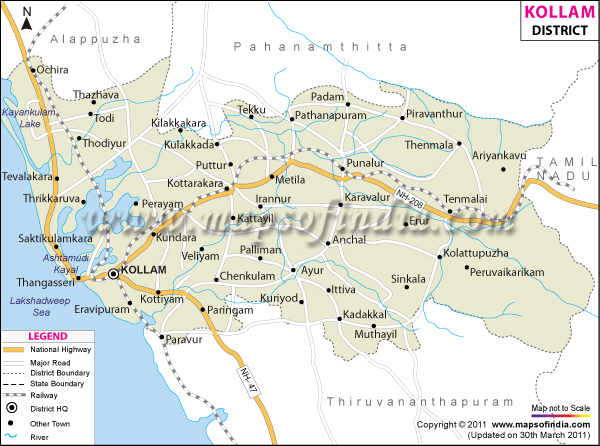
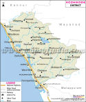
The narrative unfolds like a historical thriller. It's the story of Kollam district as a grand historical thriller. The area had been an important port of trade long before the present administrative lines were defined. There are records that Kollam (Quilon in the past) had commercial relations with the traders from China, Arabia and Europe. The old port became a major trading port on the Malabar Coast. This significance is evident from the Kollam district map, which shows that this is a coastal region, with sea routes to the outside world directly running along its borders.
This area was part of many strong kingdoms throughout the centuries: Venad and later Travancore. Its fate was determined through political quarrels, business competition and strategic partnerships. Local administration, architecture and trade networks have been influenced by the Portuguese, Dutch and British. These changes have whetted not only the curiosity of the general public but also spurred the city of Kollam to become relevant as a hub of commerce and cultural exchange.
The district has many religious sites such as temples, churches and mosques. Festivals are celebrated and marked with much enthusiasm and splendour. Onam, which showcases several cultural events and feasts, gathers the communities in a state of festivities and several sports activities which are celebrated on this day with a competitive spirit.
The district is also somewhat famed for its folk arts and for its festival events at the temples, and its traditional music. Art forms such as Kathakali, Mohiniyattam, and ritual performing practices are still drawing the crowds. When viewed from a Kollam district map, the heritage is scattered throughout the towns, villages and the rural settlements to reflect the interaction between cultural heritage and daily life rather than clustering at select historic places.
The district has its identity enriched by food traditions. Main foods of the coastal regions are seafood, while those of inland regions are rice, coconut, tapioca and spices. Generations have passed down culinary traditions that not only reflect local resources but also are influenced by outside trading experiences.
Economy
Kollam district has an interesting mix of traditional industries and development. The primary, agriculture, services and fisheries sectors all help to boost economic growth. The district has been recognised for the development of its cashew industry and it is still considered to be of economic significance in Kerala.
The government sector is greatly important in the administration, welfare services, education, health services and infrastructure works. Many government offices, educational institutions, hospital jobs and development agencies are also offering jobs. The geography through the Kollam district map can be detailed to show administrative centres that are key points of governance and public services. Expenditure on transport, urban transport, rural development and social welfare continues to help drive progress in the region.
The Public Sector plays an important role in the district's economic base as well. Employment and economic activity are fostered through public enterprises related to industrial, transport and development-related enterprises. In the past, there had been growth of institutions related to cashew, development projects for fisheries, and a number of cooperative organisations. The Kollam district map can be seen from which how industrial/commercial activity spreads around the district and how it is related to the adjoining rural areas around these centres.
The overall Services Sector has become one of the most vibrant sectors in the local economy. A significant portion of the population is associated with banks, schools, hospitals, information technology, retail shops, hospitality and the tourism industry. The city of Kollam has several Commercial establishments that are dependent on people and Tourism. District's educational institutions are drawing students from various corners of Kerala, and the healthcare centres serve to spur development in the region.
One of the best-known industries of the district is the production of Cashew nuts. Kollam has been identified with India's cashew export industry for decades. Coir, fisheries, rubber cultivation, coconut production and spices are also economic activity sources. Fishing communities contribute to the economy of the coastal area, and in the inland areas, agriculture and plantation crops contribute to the economy.
Rather, the economics of Kollam is one of several industries, rather than one prevailing over the others. It rather looks like a multi-sector and evolving production whose components exchange during a continuous process, aiming to provide sustainable growth and employment.
Tourism
Kollam's tourist experience is like a cinematically melodramatic adventure. There are waterways in the distance. Old buildings are laid out next to modern buildings. In the forest, winds play across the mountains and tell stories.
Ashtamudi Lake is one of the famous attractions of this district, as shown in the Kollam district map. This huge backwater area is famous for houseboat cruises and scenic views. Guests enjoy a relaxing and idyllic stroll through magnificent waters, coconut fringed shores and a taste of traditional village life. The lake is a source of entry to the highly renowned backwater tourism network of Kerala.
Jatayu Earth’s Center, Chadayamangalam has become a popular tourist attraction in Kerala now. It includes a massive Ramayana-themed statue, thrills and excitement with various rides/cultures and views to soak in. Sensational mix of mythology, tourism and modern-day engineering!
The first planned eco-tourism destination in India, thenmala has nature trails, adventure zone, boating and conservation tours. There is a chance for visitors to take strolls through forests and reservoirs, as well as through naturally rich areas, and to gain insight into environmental protection.
Another memorable moment on Munroe Island. Beautifully knotted islands along with canals and waterways, it is a representation of the beauty of Kerala's Backwater ecosystem. This place is amazing and possesses an intricate network of water channels that can be traced out on a Kollam district map.
Sasthamkotta Lake, the largest freshwater lake in Kerala, Mayyanad, Kulathupuzha Temple, Achankovil and many other beaches along the Arabian Sea are other important places of interest. This combination renders Kollam one of the most varied tourism regions in Kerala.
Demographics
As per the Census of India 2011, Kollam district has a population of about 2,635,375. The three essential types have been balanced and hence observed in the Kollam district map showing settlements across urban, coastal & rural areas visible at the district level.
94.09% of the people in the district are literate, which makes the district a highly literate area of India. Education is undoubtedly one of the major factors that has helped in the development of society and the economy. Education has contributed so much to the progress and development of society and the economy in general. The district also boasts many schools, colleges and professional institutions that nurture quality learning.
Malayalam is the major language of the district. Along regional boundaries and among the minority community in certain parts, Tamil is also spoken. English is an understood and used language in the education and administration settings, business and tourism.
The district is diverse in terms of religious and cultural experiences. Hinduism, Islam and Christianity were well established, and there was cultural diversity and tolerance. There was livability and cultural richness because of the significant diversity and harmony among people of Christianity, Islam and Hinduism.
Administration
Kollam district is divided into six taluks namely: Kollam, Karunagappally, Kunnathur, Kottarakkara, Punalur and Pathanapuram, for administrative purposes. These administrative units enable administration, revenue collection and delivery of public services. Planners and officials, as well as researchers, often use a Kollam district map to learn about the distribution of the administrative units.
There are about 104 revenue villages in the district. The villages are the basic units of local administration and governance. District authorities implement development programmes and public welfare programmes in conjunction with panchayats/municipalities. The interconnection of various villages, towns, transport routes and natural features of the district can be visualised through the Kollam district map which also indicates the boundaries. The Kollam district map displays the interconnection with great accuracy and usefulness.
There are municipality systems in place alongside existing institutions at the local level, ensuring development to all parts of both town and country. Administrative effectiveness is continually enhanced through infrastructure expansion, digital governance efforts and enhancements of public services.
FAQs
Q1: How many villages are there in Kollam district?
Kollam district has approximately 104 revenue villages.
Q2: What is the population of Kollam district?
According to the 2011 Census, Kollam district had a population of about 2.64 million people.
Q3: What is the Kollam district famous for?
Kollam district is famous for its cashew industry, backwater tourism, historic seaport heritage, and attractions highlighted on a Kollam district map.
Last Updated on : July 21, 2026
