






About
There is something distinct about the Alappuzha district. The district scenery is like the beginning of the opening shot of an epic thriller, with the dark monsoon clouds billowing over a sea of endless waters, coconut palms shivering with anticipation as boats frolic through enigmatic channels that fade out at the horizon. Alappuzha district is one of the most remarkable districts in any part of India, characterised by its long list of distinct backwaters, cultural heritage, big tourist industry and peculiar nature of its agrarian society.
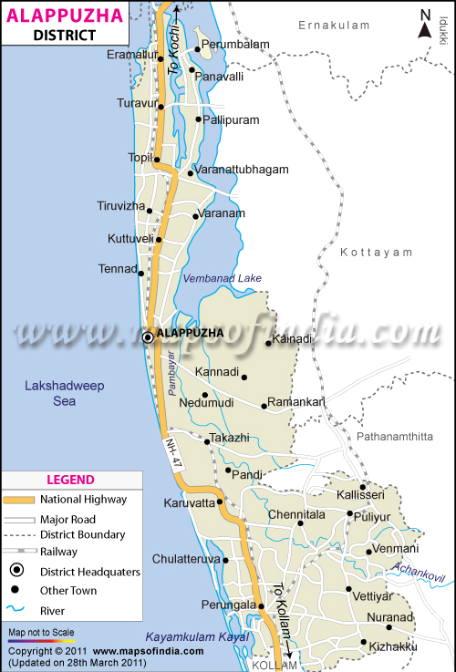
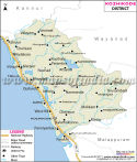
The district got a separate unique identity and was established on 17 August 1957 and was named Alappuzha district. Its central office is located at Alappuzha, which was a prominent trade-centered old historic port city as well as a major community trading centre during the Travancore era. To the north, east and south-east, it is bounded by Ernakulam, Kottayam and Pathanamthitta districts respectively; to the west lies the Arabian Sea. In addition, the Alappuzha district map shows that the district is strategically placed between land bound transport and sea bound transport.
History & Culture
The genesis of the Alappuzha district takes place over centuries of commercialisation, emigration and cultural contacts. Waterways were the most important form of transport long before the invention of modern roads and modern settlements were built up. An Alappuzha district map indicates the intricate network of waterways, which bring spices, coir products, rice and other products from local producers to markets in and further afield, offering a glimpse into the connection between the people and the products.
One of the Chief turning points in the history of the Kingdom was during the 18th century, under Raja Kesavadas, who was the Dewan of Travancore. Warehouses, markets and trade facilities developed, developing the area into one of the most prominent trade centres. Merchants from afar came in to trade spices in this booming trade. The rivers outlined in the Alappuzha district map show what became an important trade route that facilitated the economy of the Kingdom as a whole.
Alappuzha remained the seat of business and trade throughout the colonial days. Coir production became popular and became a source of employment for thousands of workers. The district was also identified with movements for social change and labour action. The workers got organised to seek betterments with the result that the state of Kerala has laid a foundation of progress in its political and social environment.
Alappuzha district, Kerala, is a district that's rich, diversified and traditional in its culture. All festivals brighten the calendar year round. The Nehru Trophy Boat Race is the most popular one among them. The event is held every year on Punnamada Lake, where the water of the lake is turned into a field of battle. In addition, long snake boats are used for a race across the lake, which entertains the crowd of keen onlookers, including tourists from all over the world. This remarkable occasion may be followed on an Alappuzha district map, through the waterways that go through it.
Religion has a profound influence on the culture of the locality. There are decades of Hindu temples, Christian churches and Muslim mosques dotted around the district, which witnesses centuries of living side by side. Ambalappuzha Sri Krishna Temple is known for its architecture and activities. The district's spiritual diversity is heartened by the presence of pilgrims from all over the country.
There are various forms of art and performing arts thriving all around the region. By performing Kathakali, Mohiniyattam and classical music, one can continue to celebrate. Folk traditions are also more important. During the Boat racing festivals, the Boat songs called Vanchipattu echo in the waterways. Handicrafts like coir weaving pass their skills from generation to generation, as they are traditional skills. The Alappuzha district map becomes an important tool to assess the celebrations and their location.
Economy
The economic significance of the Alappuzha district is an expression of the great geographical diversity of the region. The economy is balanced by a mix of agriculture, fisheries, tourism and manufacturing and services, providing a strong support to agriculture/livelihoods in both urban and rural areas.
The government sector is vital in providing administrative, educational, health care and infrastructure services. The government offices, schools, colleges and hospitals offer substantial jobs. Transportation, investment, irrigation and tourism, other than productions still support economic development.
The public sector has traditionally been supportive of a number of industries, including the coir sector. Alappuzha is considered to be one of the major coir production centres in India. Coir comes from a process of extracting it from the husks of the coconut and then turning it into ropes, mats, carpet and other items. It is important from an economic point of view for thousands of enterprises and exports of the country. Historically, the available transport corridors on an Alappuzha district map have been used to transport raw materials and goods.
The district continues to have agriculture as its main economic activity. Kuttanad, called ‘rice bowl of Kerala', has particular importance. Extensive paddy fields are irrigated in reclaimed land, which is located below sea level, by the farmers. It's an extraordinary agricultural system, a fantastic engineering and adaptation. Plans for such cultivation are best visualised in an Alappuzha district map that clearly gives the importance of the water-rich environment and the difficulties faced in carrying out such cultivation.
The fishing industry is also an important economic sector. Numerous people are employed and earning income, both from inland fishers and marine fisheries. The sector is further supported by the activities of fish processing, marketing industries and related activities. Since then the fishing has been the main source of livelihood for the coastal communities.
Over the past few decades, the services sector has grown by leaps and bounds. One of its main unique parts is tourism. There are various sources of revenue source such as hotels, resorts, restaurants, travel agencies, transport operators and houseboat service. The educational sector, healthcare and medical services, financial services and retail provide a much greater economic contribution as well.
The community has become more developed, with traditional livelihoods being maintained. This harmony between the past and the future is one of the most notable talents of Alappuzha. Thus, an Alappuzha district map helps act as an important asset to analyse economic demand and supply.
Tourism
Alappuzha District is more of an experience in film than travel. The district is known for its rich natural beauty, cultural heritage and historical importance, which draw tourists from all over India and the world.
They are certainly the most popular tourism destinations of the district – the backwaters. These lakes, canals and lagoons are connected in a unique and serene area. Travellers first come across the region when they view the Alappuzha district map, at which point, they will discover that the whole experience is even better than what they had all heard.
Vembanad is the biggest lake of Kerala and is an important tourist centre in the district. It's a great place to go fishing, travelling, recreation and an amazing place to see. There are opportunities at and around the waterways to be able to boat and bird watch and photograph, a number of these are available. The information provided in the routes on the Alappuzha district map represents an indication of the distance of the communities from the lake.
Every year, the Nehru Trophy Boat Race is held at Punnamada Lake, which holds special significance in Kerala's Culture. A composition of tradition, competition and celebration with an electrifying atmosphere is what makes the district amazing.
The Kuttanad area is interesting to travellers interested in agriculture and rural activities. It is memorable for its endless fields of paddy, the traditional methods of growing them and its lovely waterways. Kuttanad is, in fact, one of the most peculiar landscapes of rural India. It's drawn numerous tourists to the region.
Although convenient to most of the beach areas in town, which are very busy, Marari is known to be a calm beach to have some traditional beach activities. Hence, an Alappuzha district map is very important for tourists who want to visit some unique places.
Demographics
The population of the Alappuzha district, as per the 2011 Census, is 2127789. This is one of the most inhabited and developed areas of Kerala due to the habitation and development of the area. It is spread in backwaters, agriculture areas, inland towns and city villages.
One of the most literate parts of India is the district where roughly 96.26% of the district members are literate. Education has a positive contribution to social development and economic development. Malayalam is the major language in the district. English is also used in the provision of education, administration, business and tourism. The district has a religious diversity that makes it even more of a multicultural district, with the presence of Hindu, Christian and Muslim communities.
Administration
Alappuzha District is governed through an administrative setup that includes a district collector, various departments overseen by government officials, and other setups to ensure effective governance of the public. Alappuzha city is the district headquarters and serves as the administrative headquarters for the government.
Ambalappuzha, Cherthala, Chengannur and Karthikappally, along with Kuttanad and Mavelikkara, are the six tehsils into which it is divided. These tehsils supervise activities related to revenue administration, land management and local governance. One of the ways in which the Alappuzha district gets organised is to show how administrative divisions and geographical regions are divided.
In Alappuzha there are 91 revenue villages. These villages are the backbone of any local administration, and assist agriculture as well as fisheries trade and community life. The district has several Gram Panchayats, Municipalities and other local self government institutions that are responsible for development activities and public welfare programs.
It ensures the continued relevance of governance challenges with the community, where contemporary administrative structures continue to co-exist and move along with traditional systems that guarantee recurrent responsiveness to local needs as well as systemic sensitivity towards both forming a system for shaping the development agenda in contemporary times.
FAQs
Q1: How many villages are there in Alappuzha district?
Alappuzha district contains 91 revenue villages.
Q2: What is the population of Alappuzha district?
According to the 2011 Census of India, the population of Alappuzha district was approximately 2,127,789.
Q3: What is the Alappuzha district famous for?
Alappuzha district is famous for its backwaters, houseboat tourism, coir industry, Nehru Trophy Boat Race and the unique below-sea-level farming region of Kuttanad.
Last Updated on : July 22, 2026
