|
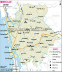
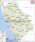
*Map showing national highways, major roads, district headquarter, etc in Kottayam District of Kerala. |
Disclaimer: All efforts have been made to make this image accurate. However Mapping Digiworld Pvt Ltd and its directors do not own any responsibility for the correctness or authenticity of the same. |
| |
Major Districts of Kerala |
|
 |
 |
 |
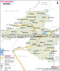 |
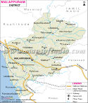
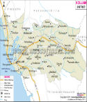
| Ernakulam District Map | Malappuram District Map | Kollam District Map | Palakkad District Map |
| | | | |
 |
 |
 |
 |
| Kannur District Map | Thiruvananthapuram District Map | Kottayam District Map | Kozhikode District Map |
| | | | other districts of Kerala >> |
The district of Kottayam in
Kerala is economically very important. It is located between 9°15' and 10° 21' North Latitudes and between 76° 22' and 77° 25' East Longitudes. The total area of Kottayam is 2,208 sq. km. It has a total population of 19,53,646. The number of male is 9,64,926 compared to 9,88,720, the number of female. The density of population in Kottayam is 885 people per square kilometer.
The lively hood of the inhabitants of
Kottayam depends mainly on agriculture. Food crops as well as cash crops and fruits are grown in this district.
The industries of
Kottayam are mainly agro-based. The steady growth in the industrial sector in this district has been highly acclaimed.
Some of the tourist destinations of the district are-
- Kumarakom
- Vembanad Lake
- Elaveezhapoonchira
- Vayaskara and Chirattamon
- Poonjar Palace
Last Updated on : May 11, 2026
