Introduction
West Bengal is a state of India that is situated in the eastern part of the country. The state consists of 19 districts and is a well developed state. All the districts add to the rich history and culture of the state as it comprises of diversity and provide a huge variety in religion, culture and tradition. The state is famous for its ancient history and the famous art, culture and music. The capital of the state is Kolkata and is one of the major cities in India.
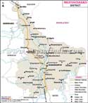
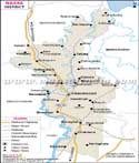
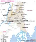
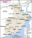
The state is famous for its rich flora and fauna. The districts of west Bengal provide religious centers, excellent sea beaches that are simply breathtaking, wild life sanctuaries, hill stations and magnificent landscape. Every district comes with a distinct factor that attracts visitors. The map provided can help you locate different districts, highways and district headquarters. The map also helps in locating important places like the capital city and the headquarters of each district. You can also find railway route, rivers, major roads, national highways that will help you to move easily in the state.
Location of West Bengal
The state is surrounded by Sikkim and the country of Bhutan to its North, Assam and Bangladesh to the east and Bay of Bengal and Orissa state to the south and to the west is Jharkhand and Bihar. Nepal is to the North West of the state. Almost three countries touch their boundaries with West Bengal making it diverse in culture, language and tradition. It has been highly influenced by these cultures that belong to different countries.
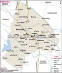
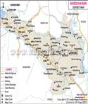
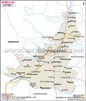
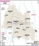
Districts of West Bengal
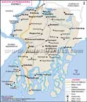
West Bengal is divided into three main divisions known as the Jalpaiguri division, Burdwan division and the Presidency division. Every division comprises of 6 to 7 districts that helps the administration to manage the state efficiently. Jalpaiguri division comprises of Cooch Behar, Darjeeling, Jalpaiguri, Maida, North Dinajpur or Uttar Dinajpur, south Dinajpur or Dakshin Dinajpur. The Burdwan division comprises of Bankura, Bardhaman, Birbhum, East Midnapore or Purba Medinipur, Hoogly, Purulla, West Midnapore or Paschim Medinipur. The presidency division holds discrits like the Howrah, Kolkata, Murshidabad, Nadia, North 24 Parganas or Uttar 24 Parganas, South 24 Parganas or Dakshin 24 Parganas.
Every district has a district magistrate or a collector for the administration of the district. Each district comprises of sub divisions with a magistrate for administration. Every subdivision is again divided into blocks that comprise of panchayats, municipalities and village councils.
List of Districts in West Bengal
| Sr. No. | District | District HQ | Population (2011) | Growth | Sex Ratio | Literacy | Area (km2) | Density (/km2) |
|---|---|---|---|---|---|---|---|---|
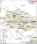
| 1 | Alipurduar | Alipurduar | * | * | * | * | * | * |
| 2 | Bankura | Bankura | 3596674 | 12.65% | 957 | 70.26 | 6882 | 523 |
| 3 | Barddhaman | Bardhaman | 7717563 | 11.92% | 945 | 76.21 | 7024 | 1100 |
| 4 | Birbhum | Suri | 3502404 | 16.15% | 956 | 70.68 | 4545 | 771 |
| 5 | Dakshin Dinajpur | Balurghat | 1676276 | 11.52% | 956 | 72.82 | 2183 | 753 |
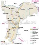
| 6 | Darjiling | Darjeeling | 1846823 | 14.77% | 970 | 79.56 | 3149 | 585 |
| 7 | Haora | Howrah | 4850029 | 13.50% | 939 | 83.31 | 1467 | 3300 |
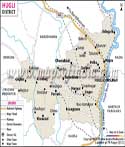
| 8 | Hugli | Hugli-Chuchura | 5519145 | 9.46% | 961 | 81.8 | 3149 | 1753 |
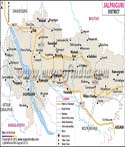
| 9 | Jalpaiguri | Jalpaiguri | 3872846 | 13.87% | 953 | 73.25 | 6227 | 621 |
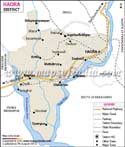
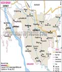
| 10 | Koch Bihar | Cooch Behar | 2819086 | 13.71% | 942 | 74.78 | 3387 | 833 |
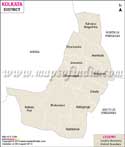
| 11 | Kolkata | Kolkata | 4496694 | -1.67% | 908 | 86.31 | 185 | 24252 |
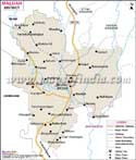
| 12 | Maldah | English Bazar | 3988845 | 21.22% | 944 | 61.73 | 3733 | 1071 |
| 13 | Murshidabad | Baharampur | 7103807 | 21.09% | 958 | 66.59 | 5324 | 1334 |
| 14 | Nadia | Krishnanagar | 5167600 | 12.22% | 947 | 74.97 | 3927 | 1316 |
| 15 | North Twenty Four Parganas | Barasat | 10009781 | 12.04% | 955 | 84.06 | 4094 | 2463 |
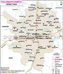
| 16 | Paschim Medinipur | Midnapore | 5913457 | 13.86% | 966 | 78 | 9345 | 1076 |
| 17 | Purba Medinipur | Tamluk | 5095875 | 15.36% | 938 | 87.02 | 4736 | 923 |
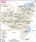
| 18 | Puruliya | Purulia | 2930115 | 15.52% | 957 | 64.48 | 6259 | 468 |
| 19 | South Twenty Four Parganas | Alipore | 8161961 | 18.17% | 956 | 77.51 | 9960 | 819 |
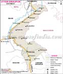
| 20 | Uttar Dinajpur | Raiganj | 3007134 | 23.15% | 939 | 59.07 | 3180 | 956 |
Last Updated on : June 24, 2026