







About
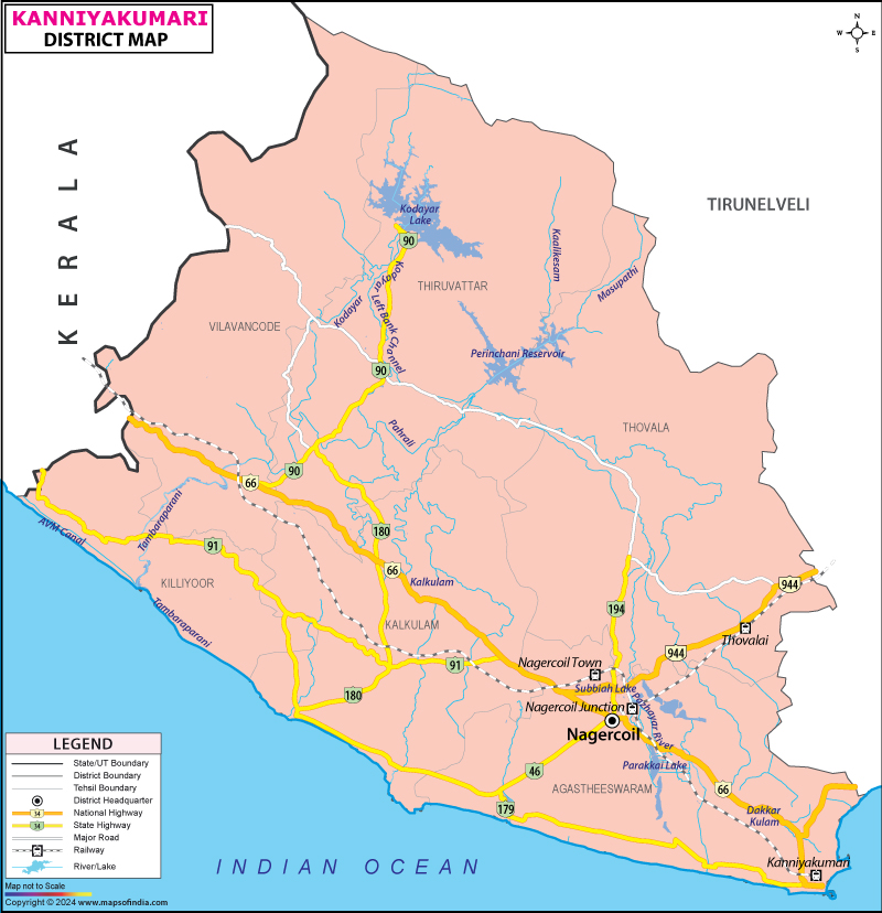
At the bottom edge of India’s map lies Kanyakumari, a small but lively region within Tamil Nadu. Water wraps around it completely on the southern side, marking where land ends and sea begins. To the northern boundary rise the slopes of the Western Ghats, known also as the Sahyadri. Along its eastern stretch runs a range again, forming a natural wall. Tirunelveli sits just beyond the northeastern border, sharing space on the regional outline. From the northwest comes contact with Kerala, adding a cultural blend through proximity. Though compact in size, every part holds a density of people, tradition, and terrain. It stands as the last piece of connected Indian soil before the open ocean takes over.
Known as "The Virgin Princess" when rendered from Sanskrit, Kanyakumari draws its title from mythological roots. This figure appears in Hindu tradition as a form of Parvati, revered yet solitary. Upon a distant stone rising from the sea, it is said she undertook severe spiritual discipline, seeking union with Shiva. Since such a bond never came to pass, she chose eternal celibacy instead. Her presence now guards the land's farthest southward reach, undisturbed.
History & Culture
Before lines on a map defined nations, Kanyakumari thrived as a center for sea commerce, sought after by warring realms. In the time of ancient Tamilakam’s Sangam period, this shoreline belonged to an area known as Nanjil Nadu. Fertile soil made agriculture flourish here, sparking endless conflict among neighboring rulers. Power shifted - first held by the early Cholas, then seized by the Cheras, eventually passing into Pandya hands.
By the close of the medieval era, authority moved toward the Venad Kingdom, later evolving into the princely domain known as Travancore. At its core stood this very district - home to Padmanabhapuram, where kings ruled until the year 1795.
Back then, with King Marthanda Varma in charge, the territory achieved something rare: a bold leap in warfare. By 1741, fighters from the land faced off against the Dutch East India Company near Colachel, then dismantled their campaign entirely. That clash marked history, standing among the scarce victories where an Asian force bested a European fleet at sea, shutting down Dutch imperial hopes fast.
Years passed since India became independent, yet fresh tensions emerged - not about colonial rule, but tongue and belonging. Though most inhabitants spoke Tamil, they lived within a territory ruled by Malayalam institutions. From that friction grew widespread resistance, later named the Kumari Liberation Movement. Headed by A. Nesamony - a figure widely respected, often referred to as Mappillai Nesamony - it drew strength from everyday citizens demanding change. Their aim was clear: to split away from Travancore and join a linguistic homeland. Success arrived on November 1, 1956, when national boundaries shifted under the States Reorganisation Act. Kanyakumari District was formed at last, folded into Tamil Nadu, where its voice fit.
In this area, Tamil and Kerala traditions blend in unpredictable ways. Architecture here reflects both cultures, not through imitation but quiet adaptation. Clothing styles, including the draped Mundu, show continuity rather than contrast. Meals unfold slowly, shaped by shared ingredients and rhythms across borders.
A notable moment came in December 1892, when Swami Vivekananda reached a rocky outcrop after swimming far from shore. There, he spent three days observing silence, turning thoughts toward time itself - past, current, ahead - before any mention of America arose. His later departure followed naturally from that stillness.
Deep within the region, religious and cultural gatherings unfold through shared participation. Though separate in origin, the Mandaikadu Kodai event, the Nagercoil Car Festival at Suchindram Temple, alongside Christmas and Eid observances, foster a collective presence. Rooted expressions such as Villu Paatu - a form of narrative music using a bow-shaped instrument - surface regularly. Even now, classical folk dances remain part of daily life across villages.
Economy
Kanyakumari's economy stands shaped by shifting tides, yet holds steady through layered activity. Maritime efforts form one pillar, while stretches of rubber trees anchor another. Instead of relying on single sources, services grow alongside agriculture. Strength emerges not from speed but persistence across sectors. Each part functions apart, yet fits within the whole.
Government Sector
Stability in jobs comes from public institutions managing administration, schools, and physical structures across the region. Alongside coastal stretches measuring 72 kilometers, financial support flows via fisheries oversight and maritime coordination under state direction. Major construction efforts appear near Colachel and Ianthayam harbors, backed by continuous investment patterns. Transport networks operated by the state, including bus services known as TNSTC, function widely. Employment emerges through ocean-focused study centers where daily work involves monitoring sea-related activity. Thousands find positions within these established frameworks, rooted deeply in regional planning.
Public Sector
Centered on large-scale industries, the area's government-backed economy thrives through key national operations. At Manavalakurichi, mineral extraction gains momentum where rare earth resources emerge from coastal sand deposits - handled by IREL, an atomic energy-linked entity. Instead of private dominance, cooperative structures shape textile production via sizable spinning facilities scattered across zones. Oversight of plantation growth appears steady due to institutional frameworks guided by rubber development authorities working quietly behind regional yields. Economic weight shifts subtly toward sustained public involvement without visible fanfare.
Services Sector
What powers growth in Kanyakumari most today? The answer lies beyond farming - it rests firmly within services. This segment expands more quickly than any other part of the local economy. Main fuel behind this rise: visitors arriving from overseas are drawn to cultural sites. Another contributor stands out - strong performance in schooling metrics across towns and villages. Together, these forces shape economic direction now.
Tourism
Situated at the southernmost tip of India, Kanyakumari draws visitors through its coastal stretches where sea meets sky in quiet contrast. Beyond the shoreline, temples rise with carvings shaped by centuries, their structures speaking silently of devotion long practiced.
Few places gather such variety so closely - a convergence not planned but grown through geography’s slow hand. On a craggy islet near shore, built during 1970, stands the Vivekananda Rock Memorial - a form shaped by multiple traditions of Indian sacred design. Shaped stone forms flow into one another, drawing eyes upward without announcement. Within its core rests Dhyana Mandapam, a chamber meant for stillness. People arrive there from distant places, drawn not by sound but silence. Thought slows inside that space, gently pulled inward like a tide at dusk.
Near the rock memorial stands a towering stone figure, 133 feet high, dedicated to Thiruvalluvar, a revered Tamil sage and poet. This immense stature reflects the number of chapters found within his renowned work, the Tirukkural. Each foot corresponds to one chapter, forming a quiet link between form and text. Carved in solid stone, it rises without ornament, marking presence through proportion alone. Though silent, its dimensions speak directly to the structure of ancient wisdom preserved across centuries. The monument does not shout; instead, it aligns measure with meaning, inch by inch. From afar, it appears still, yet holds motion in how light moves along its surface at different hours. Its placement beside the sea adds weight, as if land and water together frame memory. Not built for spectacle, it exists because certain thoughts deserve space beyond words. What remains is neither temple nor tomb, but an upright thought given mass and shadow.
Among historical sites near Thuckalay stands Padmanabhapuram Palace, built during the 1500s. This structure reflects classic architectural methods native to Kerala, relying heavily on timber craftsmanship. Ornate carvings cover many surfaces where aged ceiling panels remain intact over time. Beneath parts of the building, hidden tunnels extend without a clear purpose now known. One room dominates the complex - spacious enough for large gatherings of advisors long ago.
High above the Pahrali River rises the Mathur Aqueduct, stretching as one of Asia's most extended elevated channels. Standing firm atop 28 sturdy supports, its structure was shaped solely for carrying water to farmlands. From such elevation, sightlines sweep widely across thick clusters of coconut palms rooted deep beneath. Length and height combine here in rare measure, making it a notable work among continental irrigation systems.
Vattakottai Fort stands by the shore, shaped in a ring. Built long ago using strong stone pieces, it rose during the 1700s under the guidance of Eustachius De Lannoy, a military leader serving Travancore. Seated at the water's edge, it extends boldly into the ocean. From there, sightlines stretch across quiet waves toward distant hills known as the Western Ghats.
Demographics
What sets Kanyakumari apart begins with its population structure - remarkably unique when compared to national patterns. Social progress here reaches levels rarely seen elsewhere across India.
With 1,870,374 people counted in the latest Census figures, Kanyakumari stands out across India. Though similar in size to some regions, it packs more residents per square kilometer than most. Instead of sprawling villages, homes cluster into towns - more than eight in ten live where streets meet services. Where others remain rural, here city-like areas shape daily life. Urban patterns define much of how space is used. Most dwell within reach of markets, schools, and clinics.
Among districts in Tamil Nadu, Kanyakumari leads in literacy, reaching 91.75% on average - a figure well beyond India's overall rate. At 89.90%, female literacy shows strong educational access for women. Male literacy, slightly higher at 93.65%, suggests consistent learning opportunities across genders. Historical commitment to schooling helps explain such outcomes. Social progress here ties closely to decades of prioritizing education.
Tamil stands as the main first language, officially recognized and used by more than 98 percent of people here. Because of deep historical links to the old Travancore state and close location next to Kerala, many residents speak, or rely on Malayalam, particularly toward the west of the area. High rates of reading and writing skills help explain why English spreads so commonly across daily communication.
Administration
Though small in size, Kanyakumari functions through clearly defined units that support smooth local management. At the center of it all sits Nagercoil - home to the main government offices and also the biggest settlement in the area. Governance flows outward from this hub, adapting to a community marked by high education levels and dense living patterns.
Split across two main revenue zones - Nagercoil and Padmanabhapuram - the area unfolds into six smaller units known as tehsils. These subdivisions carry out local governance tasks under the larger divisional framework. Each taluka operates within defined boundaries, supporting regional administration. Governance flows through these segments, ensuring structured oversight. Though separated by function, they align under common administrative goals. Their setup allows focused management without overlapping roles.
Most local administration happens across 99 revenue villages and 56 Town Panchayats within the district. Nagercoil Municipal Corporation handles city-level duties, while smaller towns operate under their own bodies - Colachel, Padmanabhapuram, and Kuzhithurai being three. Another municipality shares the same name as one of them. Though rural zones rely on traditional structures, urban spots follow elected civic systems. Each town manages services independently despite shared regional oversight. Administration is split clearly between village setups and municipal frameworks.
| Facts of Kanyakumari District | |
|---|---|
| Official Name | Kanyakumari |
| Location | Tamil Nadu |
| Area | 1672 sq. km |
| Population | 1870374 |
| Language | Tamil |
FAQs
Q1: How many villages are there in the Kanyakumari district?
There are 95 panchayat villages in the district.
Q2: What is the population of the district?
The population of the district, according to the 2011 census, is 1870374.
Q3: What is the district famous for?
On Kanyakumari's tip, three seas meet - this rare blend draws eyes at dawn and dusk alike. Standing beyond the waves, a rock holds a tribute to Vivekananda, reached by boat each day. Rising nearby, a towering figure honors poet-saint Thiruvalluvar, carved tall against the sky. Not far inland, an old palace built of timber tells stories through its halls and frames. This region also stands apart for learning, where reading and writing reach deep into homes.
Last Updated on : July 16, 2026
