
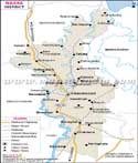
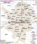
Paschim Medinipur - West Bengal
Paschim Medinipur falls in the state of West Bengal, India and was formed on January 1, 2002. Today there are two Medinipur, Paschim Medinipur and Purba Medinipur. The district comprises of 4 sub divisions namely the Kharagpur, Ghatal, Medinipur Sadar and Jhargram. It is today a part of red corridor. It is also one of the country's backward districts. It covers a total land area of 9295.28 square kilometers and is one of the largest districts in the state. The district is predominantly an agriculture district that cultivates paddy, mulberry, mango, guava, lemon, cashew, banana and jackfruit.
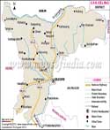
Location of Paschim Medinipur district
Pashcim Medinipur lies to the south west of the state of West Bengal. It is surrounded by Bankura to the north, state of Jharkhand to the west, Hugli to the north east and Orissa to the west. Purba Medinipur lies to the east of Paschim Medinipur. The district lies between 21 degree 47 minutes and 23 degrees north latitude and between 86 degrees 40 minutes and 87 degrees 52 minutes east longitude. The head quarters are located in Medinipur city.
Transportation in the district
Paschim Medinipur has two highways National Highway No. 6 and 60 that pass through the district and help in connecting to various parts of the district and the state. The major roads connect to cities like Chandrakona, Garhbela, Ghatal, Binpur, Keshpur, Kharagpur, Dantan, Egra, Kanthi, Khajuri, and many more. Railway station is found in Kharagpur and is an important junction as well. It is a main railway station for south eastern railway and is located centrally. It is a good means of transport as it provides connectivity to various parts of the country.
Important places
Some of the important places in the district are Khirpai, Kahrgeshwar, Umapati Shiv mandir, Chandrakona, Karnagarh and many more. Several small villages too are important as they have railway station like Belda, Nikursini, Tamluk and Kajlagarh. River Sunbarnarekha flows through the district along with Kasai and others through the district.
District profile
Tourism is a great attraction here. Gurguripal Eco tourism and Chandra eco tourism are worth mentioning. The population of the district was 5,943,300 of which 3,032,630 and female were 2,910,670 in 2011. The population density per square kilometer was 556. Literacy rate was 80 percent in 2011, where the male literacy rate was 87 percent and female at 72 percent. Sex ratio was 960 girls per 1000 boys.
| Facts of Paschim Medinipur District | |
|---|---|
| State | West Bengal |
| District | Paschim Medinipur |
| District HQ | Midnapore |
| Population (2011) | 5913457 |
| Growth | 13.86% |
| Sex Ratio | 966 |
| Literacy | 78 |
| Area (km2) | 9345 |
| Density (/km2) | 1076 |
| Tehsils | Binpur I, Binpur II, Chandrakona I, Chandrakona II, Dantan I, Dantan II, Daspur I, Daspur II, Debra, Garbeta I, Garbeta II, Garbeta III, Ghatal, Gopiballavpur I, Gopiballavpur II, Jamboni, Jhargram, Keshiary, Keshpur, Kharagpur I, Kharagpur II, Midnapore, Mohanpur, Narayangarh, Nayagram, Pingla, Sabang, Salbani, Sankrail |
| Lok Sabha Constituencies | Medinipur, Ghatal, Jhargram (ST), Arambag (SC) |
| Assembly Constituencies | Dantan, Nayagram, Gopiballavpur, Jhargram, Keshiary, Kharagpur Sadar, Narayangarh, Sabang, Pingla, Kharagpur, Debra, Daspur, Ghatal, Chandrakona, Garbeta, Salboni, Keshpur, Medinipur, Binpur |
| Languages | Bengali, Hindi |
| Rivers | Subarnarekha |
| Lat-Long | 22.416107,87.384453 |
| Travel Destinations | Khargeswar Shiv Mandir, Umapati Shiv Mandir, Malleswar Mahadev Temple, Navaratna Temple, Khalsa Shiv Temple, Temple Of Garbeta, Konoreswar Temple, Radhaballvjiu Temple, Temples Of Karnagarh, Kali Temple, Tomb Of 'Pir Lohani Baba, Jora Masjid etc. |
| Government Colleges/Universities | Belda College, Bhatter College, Chaipat S.P.B. Mahavidyalaya, Chandrakona Vidyasagar Mahavidyalaya, Debra Thana Sahid Kshudiram Smriti Mahavidyalaya, Garhbeta College, Ghatal Rabindra Satabarsiki Mahavidyalaya, Gourav Guin Memorial College, Institute of Science and Technology, Jhargram Raj College, K.D. College of Commerce and General Studies, Kharagpur College, Midnapore College, Midnapore Law College, Midnapore Medical College and Hospital, Narajole Raj College, Pingla Thana Mahavidyalaya, Raja Narendra Lal Khan Women's College, Sabang Sajani Kanta Mahavidyalaya, Santal Bidroha Sardha Satabarsiki Mahavidyalaya, Seva Bharati Mahavidyalaya, Silda Chandra Sekhar College, Subarnarekha Mahavidyalaya, Sukumar Sengupta Mahavidyalaya, Vidyasagar Teachers' Training College, Vidyasagar University, Vivekananda Satavarshiki Mahavidyalaya etc. |