
Birbhum - West Bengal
In West Bengal, India lies the state of Birbhum. It is an administrative district and is the northernmost district of Burdwan division from one of the three administrative divisions of the state. It is fondly called "the land of red soil" and is famous for the topography and its varied heritage. Prominent factors of the district are the alluvial farmlands, the bushy region, the history of the district and of course the Santiniketan, which is renowned worldwide. Plenty of rivers flow from the district making it very fertile and apt for agriculture.
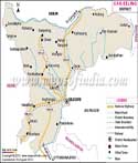
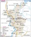
Location of Birbhum
The district is situated between 23 degree 32'30" and 24 degree 35' 0" north latitude and 87 degree 5' 25" and 88 degree 1' 40 " east longitudes and occupies around 1,755 sq kilometers. It is surrounded by districts as well as rivers. In between the districts of Birbhum and Bardhama flows the river Ajay. It forms the southern base and here lies the state of Bardhama. Jharkhand state is at the northern and western border and to the east is Murshidabad.
Towns and Villages
The district headquarters lie in Siuri and is the center of administration. There are various important towns like the Murarai, Nalhati, Rampur Hat, Muhammad Bazar, Mayureshwar, Labpur, Khyarsole, Dubrajpur, Ilam Bazar and Bolpur. The places can be easily located in the map that provides details of reaching the place and other important places. Some of the important villages are Gadadhapur, Swadinpur, Nrayanpur, Ganutla and Tantipara.
Transport in Birbhum
The district boosts of highways and major roads ways. National Highway No. 60 runs through the center of the district connecting it to various places and also other states and rest of the country. Rail line also passes through the district and connects conveniently with the rest of the country. The main railway station can be found at Siuri. Total 16 express trains stops at this station. The station belongs to eastern railway, Asansol Jn. Nalhati Jn railway station also connects to other neighboring stations like Takipur, Swadinpur, Mayureshwar, Chinpal and Bataspur.
About Birbham
Birbhum had a population of 3,502,387 in 2011 and the density of the population was 770 per kilometer square. The literacy rate was 70.90 percent in 2011 and the sex ratio was 926 girls for every 1000 boys. The district comprises of three divisions, Suri sadar, Bolpur and Rampurhat. Hindus can be seen prominently in the district that comprise of 65% population, followed by 33% of Muslims. There are other religious groups as well.| Facts of Birbhum District | |
|---|---|
| State | West Bengal |
| District | Birbhum |
| District HQ | Suri |
| Population (2011) | 3502404 |
| Growth | 16.15% |
| Sex Ratio | 956 |
| Literacy | 70.68 |
| Area (km2) | 4545 |
| Density (/km2) | 771 |
| Tehsils | Bolpur Sriniketan, Dubrajpur, Illambazar, Khoyrasol, Labpur, Mayureswar I, Mayureswar II, Mohammad Bazar, Murarai I, Murarai II, Nalhati I, Nalhati II, Nanoor, Rajnagar, Rampurhat I, Rampurhat II, Sainthia, Suri I, Suri II |
| Lok Sabha Constituencies | Bolpur (Sc), Birbhum |
| Assembly Constituencies | Dubrajpur, Suri, Bolpur, Nanoor, Labhpur, Sainthia, Mayureswar, Rampurhat, Hansan, Nalhati, Murarai |
| Languages | Bengali, Hindi, English, Urdu |
| Rivers | Mayurkashi, Ajay |
| Lat-Long | 23.840626,87.626152 |
| Travel Destinations | Santiniketan, Chhatimtala, Dehali, China Bhavana, Black House, Santiniketan Griha, Uttarayana, Shyamali, Udayana, Tarapith, Kankalitala, Fullora Temple, Daldali Lake, Nanoor, Joydev-Kenduli, Bamni Kalibari, Bhabatarini Kalibari, Dangalpara Anandpur Sarbajanin Matrimandir, Radha Ballav Mandir, Shani Mandir, Damodar Mandir, Rabindrapalli Kalibari, Rakshakali Temple, Kendua Dakshin Para Kali Mandir, Shahid Bhagat Singh Park, Nalateswari Temple, Mohammedan Saint Hazrat Data Meheboob Shah Wali, Kalidaha tank, Kaleswar Siva Mandir etc. |
| Government Colleges/Universities | Visva-Bharati University, Kabi Joydeb Mahavidyalaya, Kabi Nazrul College, Krishna Chandra College, Sambhunath College, Suri Vidyasagar College, Birbhum Institute of Engineering & Technology, Birbhum Mahavidyalaya, Purni Devi Chaudhuri Girls' College, Turku Hansda-Lapsa Hemram Mahavidyalaya, Chandidas Mahavidyalaya, Rampurhat College, Hiralal Bhakat College, Sailajananda Falguni Smriti Mahavidyalaya etc. |
Last Updated on : June 24, 2026