 Map")


| Travel to Karnataka | |||
 Bengaluru Travel Map |
 Bengaluru Metro Map |
 Bangalore Road Map |
 Bengaluru Railway Map |
History
Bangalore was earlier known as Bengaluru. It has a long and complex history that contains numerous kingdoms, kings, and cultures that influenced it over time. What started off as a little community has expanded to become one of India's most important cities.
The evidence of human life in present day Bangalore goes back to 1000 of years. Stone artifacts found near the city prove that people lived here even in prehistoric times. However the documented history of the region dates back to the ninth century. An antique stone inscription unearthed in Begur, dated to 890 CE, references the term “Bengaluru.” This shows that throughout the Western Ganga dynasty's control, the region was already recognized and inhabited.
The area was ruled by a number of South Indian rulers in the early medieval era. The Western Gangas were succeeded by the Cholas, who dominated portions of Karnataka throughout the 10th and 11th centuries. The Hoysalas later became influential in the region. Small communities surrounding it grew slowly because of the assistance these rulers provided for local trade, agriculture, and temple construction.
When Kempe Gowda I, a chieftain in the Vijayanagara Empire, established Bangalore as we know it today in 1537, it was a major turning point in the city's history. He constructed a well-planned town with streets, marketplaces, and water tanks, as well as a mud fort. Kempe Gowda also established the limits of the city by erecting four watchtowers, some of which still survive today.
When the Vijayanagara empire declined, Bangalore moved in the hands of various rulers. The Mughals eventually conquered it after the Bijapur Sultans had originally gained control of it. In 1687, the Mughal emperor Aurangzeb handed it over to Chikkadevaraja Wodeyar of Mysore. The city developed into a military and administrative hub during the Wodeyars.
The kings of Mysore, Hyder Ali and his son Tipu Sultan, took control of the region in the late eighteenth century. Tipu Sultan upgraded the city’s fortifications and constructed stone walls around the fort. In addition, he developed new businesses like silk manufacture and encouraged commerce. During this time, it was well-known for its marketplaces and talented artisans. With the defeat of Tipu Sultan in 1799, Bangalore passed in the hands of the Britishers. The city was separated into two parts: the ancient native town, or "Pete," and the new British-controlled cantonment. The cantonment was designed to host British troops and officials and had large roads, homes, churches, and clubs. This split influenced social and cultural life for decades.
The Britishers for the individual gains, developed the region and worked to improve the administration of the place. The city grew to be a prominent military post, as well as an educational and scientific center. The region gained a strong intellectual foundation thanks to institutions like the Indian Institute of Science, which was founded in 1909. Railways, telegraphs, and modern industries were established, connecting the city with the rest of India.
After India gained independence in 1947, it became a part of the state of Mysore, which subsequently became Karnataka. In 1956, it was named the capital of the newly formed state. Following independence, industry grew rapidly, especially in public sector industries like aircraft, machine tools, and electronics. Bangalore became India's hub for IT starting in the late 20th century. The city is currently known as the "Silicon Valley of India" due to the growth of startups, software companies, and research institutions. It has worked to preserve its parks, lakes, and cultural heritage despite growing urbanization.
Culture
Bangalore's culture has developed gradually over many years. Both long-term residents and those who came later for employment or schooling are represented in it. Even though the city has undergone significant transformation, many of the old customs and ideals are still evident in day-to-day activities.
The primary language spoken in the area is Kannada. It is used in local businesses, marketplaces, and homes. Many people take satisfaction in using it. Bangalore, however, is accustomed to hearing a wide variety of languages. Common languages include Tamil, Telugu, Malayalam, Hindi, and English. As a result, most individuals here are open and patient with one another. Changing languages during a single discussion is common.
An important aspect of the local culture is food. Traditional meals are substantial and easy to prepare. Every day, we use rice, lentils, vegetables, and seasonings. Foods like ragi mudde, saaru, bisi bele bath, dosa, and idli are popular. These dishes are inexpensive at small local eateries. Home-cooked meals are still preferred by many families, particularly on weekends and during holidays. Over time, eating cuisine from many parts of the world has also become commonplace.
Chinese, North Indian, and bakery goods are easily accessible. Festivals are a peaceful and vital means to unite people. The Kannada New Year is celebrated on Ugadi with special food and prayers. Dussehra and Deepavali are also important. Families visit temples, lamps are lit, and homes are cleaned. Festivals are also observed by people of other faiths. Christmas and Eid are celebrated with kindness and respect. Everyday existence is made cozier by these events.
The city is consistently filled with music and art. Classical music events are presented in modest rooms and temples. Children are encouraged to learn dance or music by many families. There are also busy book readings and theater organizations. At the same time, modern music and local bands are popular among young people.
This combination shows the coexistence of traditional and modern concepts. Calm conduct is valued in Bangalore daily life. People typically avoid direct disagreement and speak in a courteous manner. Education and secure work are priorities for most families. Common routines include evening tea, park trips, and morning walks.
Language
Bangalore has a multilingual population due to the city's long history of immigration. This mixture has influenced how individuals interact and communicate with one another on a regular basis.
The primary language spoken in the area is Kannada. It is utilized in local markets, government offices, and educational institutions as Karnataka's official language. At home, the majority of long-term inhabitants speak Kannada. Additionally, it is the language spoken at regional celebrations and cultural gatherings.
In several areas of the city, Tamil is extensively spoken. Bangalore has long been home to Tamil-speaking families, particularly in the city's oldest areas. Telugu is another frequent language. Telugu is widely spoken in homes and communities by residents of neighboring districts in Andhra Pradesh and Telangana.
Malayalam is spoken by persons who have relocated here from Kerala. It's commonly heard in neighborhoods and workplaces. Hindi is also widely spoken, particularly by persons who came from North India for work or study. It enables people from many places to converse easily.
English is used extensively in Bangalore. It's used in offices, institutions, and the technology industry. Many people transition between English and their native tongue without thinking. This is normal in regular discussion.
Because so many languages are spoken in Bangalore, people are accustomed to listening and adapting. Language rarely becomes a barrier. Instead, it embodies the city's open and collaborative way of life.
Geography
Bangalore lies in southern India, on the Deccan Plateau. The city is located at an average elevation of roughly 900 meters above sea level. This high elevation differentiates it from many other important Indian cities. The terrain around the city is primarily flat to moderately rolling, with minor hills and rocky outcrops in some places. These rocks are very old and belong to one of India's oldest geological formations.
There is no big river that flows through the region. Instead, it is based on a network of lakes and man-made tanks. Many of these bodies of water were established hundreds of years ago to store rain. They played an important part in agricultural and daily living.
The climate of Bangalore is generally temperate and pleasant when compared to coastal or northern cities. Summers are warm but not hot. Temperatures typically range around 20 and 35 degrees Celsius. The heat is frequently dispersed by cold evenings and occasional winds. Winters are comfortable and dry.
The nighttime temperatures can fall to between 12 and 15 degrees Celsius, making mornings cold. The city receives most of its rainfall from the southwest and northeast monsoons. Rain usually falls between June and November. Showers might be heavy at times, but they are often short. Parks, trees, and gardens are common sights.
| Particular | Details |
|---|---|
| Official Name | Bangalore |
| Location | Karnataka |
| Area | 741 sq. km |
| Population | 8,443,675 |
| Language | Kannada |
FAQs
Q.1:Which are the top tourist attractions in Bangalore?
Some of the famous tourist attractions in Bangalore areYelahanka Satellite Township, Madivala Tank, BTM Layout, Bull Temple, Biotechnical Garden, St Andrew's Church, Lal Bagh Gardens, Bengaluru International Airport (Kempegowda International Airport), Golf Course of Bangalore, Tipu Sultan's Summer Palace, Bangalore Palace, Cubbon Park, Varthur Kere, Mayo Hall, Vidhana Soudha, Venkatappa Art Gallery, Visvesvaraya Industrial and Technological Museum, Bangalore Museum and Karnataka High Court.
Q.2:Why is Bangalore known as India's Silicon Valley?
Bangalore is known as India's Silicon Valley because it emerged as the country's primary hub for information technology, software firms, startups, and research institutes, particularly following the 1990s economic boom.
Q3:Which is the primary language spoken in Bangalore?
Kannada is the primary and official language spoken in Bangalore. It is commonly used in government, schools, local markets, and everyday conversation among long-term residents.
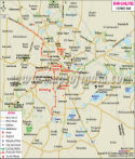
Tourist Attractions in Bengaluru:
There are many tourist places in the city which have been highlighted in this map and they include the following:
- Yelahanka Satellite Township
- Madivala Tank
- BTM Layout
- Bull Temple
- Biotechnical Garden
- St Andrew's Church
- Lal Bagh Gardens
- Bengaluru International Airport (Kempegowda International Airport)
- Golf Course of Bangalore
- Tipu Sultan's Summer Palace
- Bangalore Palace
- Cubbon Park
- Varthur Kere
- Mayo Hall
- Vidhana Soudha
- Venkatappa Art Gallery
- Visvesvaraya Industrial and Technological Museum
- Bangalore Museum
- Karnataka High Court
Places to Visit near Bengaluru:
- Bannerghatta National Park
- Wonder La
- Nrityagram
- Muthyala Maduvu
- Ranganatha Swamy Temple
- Shivaganga Hill
- Janapada Loka
- Nandi Hills or Nandidurga
- Anthargange
Best Time to Visit:
The weather of Bengaluru is truly enjoyable and as a result the city attracts thousands of travelers round the year. However, the highest tourist inflow is seen during months between September and February.
How to Reach Bengaluru:
By Air:
The city is well-connected by flights from Delhi, Mumbai and many other important cities of the country as well as abroad. It takes 45 minutes to reach the airport from the main city.
By Train:
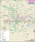
There are two important railway stations in the city - Bengaluru City Railway Station and Yeswantpur Junction. Trains are available on regular basis from both the railway stations. The Bangalore Metro Rail Corporation has set up Namma Metro, an intra-city rail network.
By Bus:
Buses ranging from air-conditioned, Volvo to sleeper coaches are available for Bengaluru from Goa, Mumbai, Pune, Coimbatore and Mangalore. Some buses are also run by Karnataka State Road Transport Corporation.
A First in Country: Bengaluru Get its Own Logo
Bengaluru became the first city in India to get its own logo, joining the leagues of world-class cities like London, New York, Melbourne, Paris and more. The logo depicts city's name only, with BE, the first two letters, and U, the last letter in red. The colour can be changed to green, yellow or red depending on the occasion. The eye-catching logo was revealed at the 'Namma Bengaluru Habba' fest to the cheering audience.
Karnataka's tourism minister, Priyank Kharge said the logo will boost the city's identity and will fetch economic gains.
Bengaluru Facts
| State | Karnataka |
|---|---|
| District | Bengaluru |
| District Headquarters | Bengaluru |
| Tehsil/Taluk | Four Taluks: Bangalore - East, West, South, and Anekal |
| Lat Long | 12.972358,77.594619 |
| Area | 741 sq km |
| Population as per 2011 | 8443675 |
| Official Languages | Kannada and English |
| Time zone | IST (UTC+5:30) |
| STD Code | o80 |
| Transport | Air, Rail, Road |
| Vehicle registration | KA-01 |
| Food and Cuisine | South Indian, North Indian, Chinese, Street Food |
| Religions | Hinduism, Christianity, and Islam |
| Festivals | Bangalore Karaga, Kadalekaye Parishe, Makara Sankranthi, Gowri Habba, Ganesh Chaturthi, Krishna Janam Ashtami, Dussehra, Deepavali, Mahashivratri, Ugadi, Varamahalakshmi |
| Monuments | Vidhan Soudha, Tipu Sultan's Palace, Attara Kacheri (High Court), Seshadri Iyer Memorial Hall, Bangalore Palace |
| Places of interest | Lal Bagh, Bangalore palace, Attara Kacheri, Government Museum, Jawaharlal Nehru Planetarium, Bannerghatta National Park, Butterfly Park, Bull Temple, St. Mary's Basilica, Shivanasamudra Falls, Mysore, Ulsoor Lake, ISKCON temple complex, Someshwara Temple, Vidhana Soudha, Tipu Sultan's Palace, Cubbon Park, and many more |
| Markets | Brigade Road ,Commercial Street, M.G. Road, Residency Road, Sampige Road, Malleswaram Marathahalli Main Road , Jayanagar Shopping Complex, Gandhi Bazaar, Chickpet, KR Market/City Market, Gandhi Bazaar, N R Colony, Banashankari, Malleswaram, Jayanagar, JP Nagar Shivajinagar, Bangalore Central, Cosmos Mall, Garuda Mall, Garuda Swagath Mall, Gopalan Mall, Leela Galleria, Lido Mall, Mantri Square, Royal Meenakshi Mall, Sigma Mall, The Collection, The Forum, Value Mall |
| Hotels | The Leela Palace Bangalore, Ramada Encore Domlur Bangalore, Citadines Richmond Bangalore, The Elanza Hotel, Mango Hotels, Bangalore - Koramangala, Elmas Hotel, Mango Hotels, and many more |
| Industries | Information Technology (IT), Aerospace and Aviation industries, Manufacturing Industries, Space technology, Electronics City, industrial park, Research and Development (R&D), electronics and software production |
| University/College | University Visvesvaraya College of Engineering, Visvesvaraya Technological University, R.V. College of Engineering, PES Institute of Technology, BMS College of Engineering, M. S. Ramaiah Institute of Technology, Bangalore Institute of Technology, Indian Institute of Management, Bangalore; National Institute of Mental Health and Neuro Sciences, St. John's Medical College, Bangalore Medical College and Research Institute, Sir M. Visvesvaraya Institute of Technology and Dayananda Sagar College of Engineering |
| Notable people | K.C. Reddy - Former Chief Minister, H.D. Deve Gowda - Former Prime Minister, Siddaramaiah - Former Deputy Chief Minister, Kuvempu - poet, Jnanpith awardee, Masti Venkatesh Iyengar - Jnanpith awardee, T. P. Kailasam - Kannada writer, playwright; Sir M. Visvesvarayya - engineer and statesman, Dr. Krishnaswamy Kasturirangan - astrophysicist, former Chairman of ISRO, member of Rajya Sabha. |
MOI.AB.16.01.17
Last Updated on : May 11, 2026