
Howrah - West Bengal
Howrah is also known as Kolkata's twin city. It is quite a populous city and is second largest in the state. The city serves as a major road and rail transport for the people of Kolkata metropolitan region. The most famous thing about Howrah is the Howrah Bridge, which symbolizes Kolkata as well. The bridge is the world's busiest bridge that connects to the Howrah station, which is again one of the country's largest railway stations.
Howrah Location
Howrah is located at 22.59 degree N 88.31 degree E. Howrah lies to the south east of the state of West Bengal and is one of the important districts. To the north is Hugli district, to the east is North 24 Paraganas. Pashcim Medinipur is to the west of Howrah and to the south is 24 Praganas. The district is also covered by Hoogly River to the east and river Rupnarayan on the west. River Bhagirathi - Hooghly River flows on the east and the south east of the district.
Info on Howrah
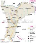
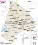
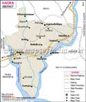
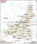
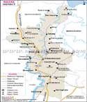
In the map of Howrah, you can find the many major roads as well as important places of interest. Visitors should carry a map with them for their guidance to reach their destination using the nearest route. NH-15 passes through the city and one can go to neighboring district using this route. The city is well connected to various other cities in the state via the railway route as well. The head quarter is situated in Howrah city. Some of the important places are the Amta, Jagatballabhpur, Metiaburx, Uluberiay, Bauria, Kolaghat, Bagnan and Syampur.
Howrah profile
The population of the district according to the 2011 census was 4,841,638. Male population was 2,502,453 and female population was 2,339,185. The population density was 3,300 people per sq.km. According to 2011 census, the sex ratio in Howrah was 964 girls per 1000 boys.
Places of attraction
Some of the attractions here are the Belur Math, Howrah Bridge, Indian Botanical garden, and the Howrah railway station.
| Facts of Howrah District | |
|---|---|
| State | West Bengal |
| District | Howrah |
| District HQ | Howrah |
| Population (2011) | 4850029 |
| Growth | 13.50% |
| Sex Ratio | 939 |
| Literacy | 83.31 |
| Area (km2) | 1467 |
| Density (/km2) | 3300 |
| Tehsils | Amta I, Amta II, Bagnan I, Bagnan II, Bally Jagachha, Domjur, Jagatballavpur, Panchla, Sankrail, Shyampur I, Shyampur II, Udaynarayanpur, Uluberia I, Uluberia II |
| Lok Sabha Constituencies | Howrah, Uluberia, Sreerampur |
| Assembly Constituencies | Bally, Howrah Uttar, Howrah Madhya, Shibpur, Howrah Dakshin, Sankrail, Panchla, Uluberia Purba, Uluberia Uttar, Uluberia Dakshin, Shyampur, Bagnan, Amta, Udaynarayanpur, Jagatballavpur, Domjur |
| Languages | Bengali, Hindi |
| Rivers | Hoongly |
| Lat-Long | 22.601333,88.26376 |
| Travel Destinations | Howrah Bridge, Indian Botanic Garden, Belur Math & temple, Hooghly Bridge (Vidyasagar Setu), Great Banyan Tree, museum of Anand Niketan Kirtishala, Santragachi Jheel etc. |
| Government Colleges/Universities | Ramakrishna Mission Vivekananda University, Azad Hind Fouz Smriti Mahavidyalaya, Gangadharpur Mahavidyamandir, Ramsaday College, Bagnan College, Jaypur Panchanan Roy College, Shyampur Siddheswari Mahavidyalaya, Sovaranai Memorial College, Bijoy Krishna Girls' College, Lalbaba College, Dr. Kanailal Bhattacharya College, Narasinha Dutt College, Udaynarayanpur Madhabilata Mahavidyalaya, Uluberia College, Prabhu Jagatbandhu College, Puras-Kanpur Haridas Nandi Mahavidyalaya etc. |