
Hugli - West Bengal
Hugli is situated about 40 kms from the north of Kolkata and on the west bank of the famous river Hugli. The name is derived from the river. The place is famous as a port for the Portuguese and the Moguls. Various Europeans have also visited the place like the Danish, British, Belgians, French, and the Germans. The district boosts of great tourist attractions and is the birth place of noted novelist, Sarat Chadra Chatterjee. The place has a place of significance as Sri Ramakrishna Paramhamsa spent most of his life here. Hugli has 4 sub divisions namely Chinsura, Serampore, Changannagar and Arambag.
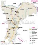
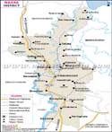
Location of Hugli
Hugli lies near the capital of West Bengal, Kolkata. The West Bengal map clearly shows Hugli's proximity to Kolkata and neighboring districts. It is around 200 meter above sea level and has river Hugli to the east. To the south is Howrah district and to the north is Bardhaman. The North West comprises of Bankura district and the south west has Medinipur district. It lies between 22 degree 51'07"N and 87 degree 54' 28" E. the head quarter is situated at Hugli Chinsurah.
Towns and villages
Various towns like Balagarh, Polba, Dadpur, Trakeshwar, Arambag, Goghat, Haripal, Khanakul, Jangipapra, Purusra and Magra are large and major towns of the district. They are connected to various other villages and to other districts as well. Smaller villages like Hajipur, Ghospur, Kesabpur, Keota, Gurup and Jamdar are well connected with smaller roads. The town Hugli - Chinsura is located on the river Hugli.
Transport in Hugli
Hugli is one of the major districts of the state of West Bengal. It boosts of convenience of transport to all the parts of the state and the country at large. The district also has National Highway No. 2 that passes through the district and makes it possible for the people to go outside the district or to the rest of the country. The district also has a railway route that helps people to commute from one place to another. Chinsura has three rail stations. It is well connected to Bandel, Burdwan, Howrah and other towns. Some express trains also stop at Chinsura station. Besides the Jubilee Bridge, there is Hugli ghat station for the Bandel Naihati local trains to stop.
About Hugli district
Hugli had a population of 5,520,389, and the male population was 2,819,100 and the female population was 2,701,289 according to 2011 census. The literacy rate was 82.55 percent in 2011 and has a sex ratio of 951 girls per 1000 boys.
| Facts of Hugli District | |
|---|---|
| State | West Bengal |
| District | Hugli |
| District HQ | Hugli-Chuchura |
| Population (2011) | 5519145 |
| Growth | 9.46% |
| Sex Ratio | 961 |
| Literacy | 81.8 |
| Area (km2) | 3149 |
| Density (/km2) | 1753 |
| Tehsils | Arambag, Balagarh, Chanditala I, Chanditala II, Chinsurah Magra, Dhaniakhali, Goghat I, Goghat II, Haripal, Jangipara, Khanakul I, Khanakul II, Pandua, Polba Dadpur, Pursura, Serampur Uttarpara, Singur, Tarakeswar |
| Lok Sabha Constituencies | Sreerampur, Hooghly, Arambag (Sc) |
| Assembly Constituencies | Uttarpara, Sreerampur, Champdani, Singur, Chandannagar, Chunchura, Balagarh, Pandua, Saptagram, Chanditala, Jangipara, Haripal, Dhanekhali, Tarakeswar, Pursurah, Arambag, Goghat, Khanakul |
| Languages | Bengali, Hindi |
| Rivers | Hooghly |
| Lat-Long | 22.897683,88.24728 |
| Travel Destinations | Bandel Church, Fur Furah Sharif, Imambara, Shri Ramkrishna Temple, Shanderswartala Temple, Hangseswari Tample, Brindavan Jew Temple, Nritya Gopal Smriti Mandir, Antpur Math, Watch Tower, Suakhal & Moyur Mahal, Jafarganj Cemetery, Joy Krishna Library, The Church Of St. Olaf, Church Of Sacre Coeur De Jesu, Church Of Sacre Coeur De Jesu, Buddha Temple, Light House Tomb, Chandannagore Museum, Chandernagore Church, Nandadulal Temple etc. |
| Government Colleges/Universities | Aghore Kamini Prakash Chandra Mahavidyalaya, Arambagh Girls' College, Balagarh Bijoy Krishna Mahavidyalaya, Bijoy Narayan Mahavidyalaya, Bidhan Chandra College, Chandernagore Govt. College, Hooghly Mohsin College, Hooghly Women's College, Kabi Sukanta Mahavidyalaya , Khalisani Mahavidyalaya, Nabagram Hiralal Paul College, Netaji Mahavidyalaya, Rabindra Mahavidyalaya, Raja Peary Mohan College, Raja Rammohan Roy Mahavidyalaya, Sarat Centenary College, Serampore Girls' College, Sree Gopal Banerjee College, Sri Ramkrishna Sarada Vidyamahapit, Swami Niswambalananda Girls' College, Tarakeswar Degree College, Vivekananda Mahavidyalaya, Vidyasagar Mahavidyalaya etc. |