
Dakshin Dinajpur - West Bengal
Dakshin Dinajpur was formed on 1st of April 1992 and comprises of two sub divisions namely the Buniadpur and Balurghat. It was created by the division of West Dinajpur district. According to the census of 2011, the district was the least populous one in the West Bengal. The district is predominantly an agriculture based area. There are plenty of rivers flowing like the Purnabhaba, Brahmani, Atreyee and Tangon to name a few. However, there are no large scale industries here. It is recognized as one of the most backwards regions of the country.
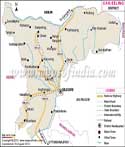
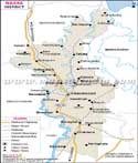
Location of Dakshin Dinajpur
The district lies between latitude 26 degree 35'15" N to 25 degree 10'55" N and longitude 89 degree 00'30" E and 87 degree 48'37"E. the area covered by the district is 2162 square kilometers. Dakshin Dinajpur is surrounded by Bangladesh to the north, east and south and to the west and south west lies North Dinajpur and Maldha. The district is situated towards the north east of the state and is a smaller district.
Towns and villages
Many small and large towns can be seen in Dakshin Dinajpur. Kishmandi, Gangarampur, Kumarganj, Taoan, Bansihari, Hilli, and Bhatra are some of the larger towns. Some villages are also important as they connected by major roads like the Patiraj, Patiram, Badalpur, and Lashkarhat. The head quarter of the district is in Balurghat, a place to the south of the district.
Transport in the district
There is a national highway No. 34 passing from the district.However there are good roads that connect the district to other parts of the state. Apart from the roads there is also a railway route that passes from the district. There are railway stations at Balurghat and Hili towns of the district. A new railway line has been laid from Eklakhi and Balurghat.
District profile
It is an agricultural district with no industry at all. The language spoken by the locals here is Bengali and the religions here are mainly Hindus and Muslims. The population of the district in 2011 was 1,670,931 and a population density of 753 residents per square kilometers. The literacy rate is 74 percent. The sex ratio in the district is 954 females per 1000 males.
Places to visit
There are not many places of tourist interest here. But due to the history of the place, some of the towns have become very popular like the Hili Block, Sarongbari, Balurghat block, College museum, Khanpur, Patiram Thakur estate, and the Bolla Ma Kali temple.
| Facts of Dakshin Dinajpur District | |
|---|---|
| State | West Bengal |
| District | Dakshin Dinajpur |
| District HQ | Balurghat |
| Population (2011) | 1676276 |
| Growth | 11.52% |
| Sex Ratio | 956 |
| Literacy | 72.82 |
| Area (km2) | 2183 |
| Density (/km2) | 753 |
| Tehsils | Balurghat, Bansihari, Gangarampur, Harirampur, Hilli, Kumarganj, Kushmundi, Tapan |
| Lok Sabha Constituencies | Balurghat |
| Assembly Constituencies | Kushmandi, Kumarganj, Balurghat, Tapan, Gangarampur, Harirampur |
| Languages | Bengali, Hindi, Urdu |
| Rivers | Atreyee, Punarbhaba, Tangon, Brahmani |
| Lat-Long | 25.413509,88.581161 |
| Travel Destinations | Sarongbari, college museum, Bolla Kali Temple, Tapan Dighi, Statue of century Darpal, Kal Dighi, Dhal Dighi etc. |
| Government Colleges/Universities | Hili Govt. General Degree College, Harirampur Govt. General Degree College for Girls, Kumarganj Govt. General Degree College, Kushmandi Govt. General Degree College for Girls etc. |