
North 24 Parganas - West Bengal
North 24 Parganas is a district in West Bengal, India and is the most populous one. It is regarded as the tenth largest district in terms of area and ranks second in the country in terms of population. The district is now divided into 5 sub divisions. The district is severely arsenic affected in the state along with 9 others. It comes under the Gangetic plains of the state. It is also a severely affected by poverty. In 1984, the district became home to Sundarbans National Park and Bibhutibhushan Wildlife Sanctuary.
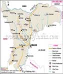
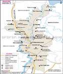
Location of North 24 Parganas
The district lies in the southernmost tip of West Bengal to the east of India. The district is bordered by Bangladesh to the north and east and Nadia district to the North. The South 24 Parganas is situated to the south along with Kolkata. To the west is Howrah, Hugli and Kolkata. The district lies between latitude 22 degree 11'6" north to 23 degree 15'2" north and from longitude 88 degree 20' east to 89 degree 5' east.
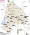
Towns and villages
The map provides details of the roads that pass from various towns. Major roads connect you to places like Bangaon, Gaighata, Habra, Baduria, Rajarhat, Harua and the Salt lake. Smaller towns are also well connected to various cities in the district and other parts of the state like the Ganrapoa, Chandpara, Gogardanga, Chaubaria, Banglani, Taki, Majhergram, Banglani, and Pirgachha. Places of importance in the district are Barasat, Barackpore, Bidhan Nagar, Basirhat etc. the salt Lake need special mention here for it is an all-inclusive township. Barrackpur is a place famous for military barracks during the British rule. The head quarters is situated in Barasat.
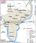
Transportation in North 24 Parganas
It is easy to reach North 24 Parganas and visitors can opt for buses, railways to reach the city. National Highway No. 35 runs from the district and connects larger towns to smaller villages to other parts of the country. The other NH No. 35 also passes through the district connecting to other towns and Kolkata. Barrackpore has a railway station, where many trains pass by or stop at the station. The district has many express trains that pass through the district as well.
North 24 Parganas profile
The population of the district in 2011 was 10,082,852, in which the male population was 5,172,138 and female population was 4,901,714. The literacy rate was 84.95 percent and the sex ratio stood at 949 per 1000 males.
| Facts of North 24 Parganas District | |
|---|---|
| State | West Bengal |
| District | North 24 Parganas |
| District HQ | Barasat |
| Population (2011) | 10009781 |
| Growth | 12.04% |
| Sex Ratio | 955 |
| Literacy | 84.06 |
| Area (km2) | 4094 |
| Density (/km2) | 2463 |
| Tehsils | Amdanga, Baduria, Bagda, Barasat I, Barasat II, Barrackpur I, Barrackpur II, Basirhat I, Basirhat II, Bongaon, Deganga, Gaighata, Habra I, Habra II, Haroa, Hasnabad, Hingalganj, Minakhan, Rajarhat, Sandeshkhali I, Sandeshkhali II, Swarupnagar |
| Lok Sabha Constituencies | Bangaon (Sc), Barrackpur, Dum Dum, Barasat, Basirhat |
| Assembly Constituencies | Bagda, Bangaon Uttar, Bangaon Dakshin, Gaighata, Swarupnagar , Baduria, Habra, Ashoknagar, Amdanga, Bijpur, Naihati, Bhatpara, Jagatdal, Noapara, Barrackpur, Khardaha, Dum Dum Uttar, Panihati, Kamarhati, Baranagar, Dum Dum, Rajarhat New Town, Bidhannagar, Rajarhat Gopalpur, Madhyamgram, Barasat, Deganga, Haroa, Minakhan, Sandeshkhali, Basirhat Dakshin, Basirhat Uttar, Hingalganj |
| Languages | Bengali, Hindi, English |
| Rivers | Ichamati, Dansa |
| Lat-Long | 22.634293,88.395195 |
| Travel Destinations | Temple of Fame, Flag Staff House, Gandhi ghat, Machranga Dwip, Parmadan Deer Park etc. |
| Government Colleges/Universities | Acharya Prafulla Chandra College, Barasat College, Barasat Government College, Barrackpore Rastraguru Surendranath College, Basirhat College, Bhairab Ganguly College, Bidhannagar College, Chandraketugarh Sahidullah Smriti Mahavidyalaya, Derozio Memorial College, Dinabandhu Mahavidyalay, Dr. B. R. Ambedkar Satabarshiki Mahavidyalaya, Dum Dum Motijheel College, Dum Dum Motijheel Rabindra Mahavidyalaya, Gobardanga Hindu College, Guru Nanak Institute of Dental Sciences and Research, Hingalganj Mahavidyalay, Kalinagar Mahavidyalaya, Kanchrapara College, Mahadevananda Mahavidyalaya, Mrinalini Dutta Mahavidyapith, Naba Barrackpore Prafulla Chandra Mahavidyalaya, Nahata Jogendranath Mandal Smriti Mahavidyalaya, Netaji Satabarshiki Mahavidyalaya, P.N. Das College, Panihati Mahavidyalaya, Prasanta Chandra Mahalanobis Mahavidyalaya, Ramakrishna Mission Vivekananda Centenary College, Rishi Bankim Chandra Colleges, Sree Chaitanya College, Sree Chaitanya Mahavidyalay, Taki Government College, Vivekananda College, West Bengal State University, West Bengal University of Technology etc. |