
Uttar Dinajpur - West Bengal
Uttar Dinajpur is an important district in West Bengal. It borders the country of Bangladesh and therefore is very sensitive place. It occupies a very narrow tract between the two countries and therefore occupies less area as compared to the other districts. The area covered is 3142 sq.km and is under the jurisdiction of the Indian Government. It was divided into north and south division after independence.
Location of Uttar Dinajpur
The district lies between 25 degrees 11'N to 26 degrees 49' N and longitude 87 degree 49' E to 90 degree 00'E. Uttar Dinajpur is surrounded by other districts of West Bengal like Darjeeling district and Jalpaiguri district to the north, Dakshin Dinajpur to the south, Bangladesh to the east and Bihar to the west. The district is made of two sub-divisions known as Islampur and Raiganj. There are several sanctuaries that are maintained by the state government. The main one being the Raiganj bird sanctuary is famous as it is one of the largest in Asia.
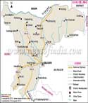
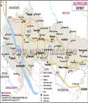
Map of Uttar Dinajpur
Although it is a small district, you will need a good map that shows all the roads and major towns and cities here. The national highway No.31 and 34 run in the district. The district headquarters is located in Raiganj. Visitors will find it convenient to use the map as they can reach places without any hassles and without wasting any time. Some of the important cities are Chopra, Islampur, Goalpokhar, Chakalia, Kaliyaganj, Itahar etc. Uttar Dinajpur boost of railway track that connects to various other cities and the rest of the country. The main rivers are the Nagar, Kulik and the Mahananda.
District Overview
According to 2011 report, Uttar Dinajpur had a population of around 3,000, 849 out of which, the male population were 1,550219 and 1,450,630 female. There has been a steady increase in the population since the last report. The density of the district is 956 people per sq.km. The literacy rate in 2011 was 60.13. While the male literacy was 66.65 and female literacy was 53.15. According to the 2011 report, the sex ratio in Dinajpur was 946 girls per 1000 boys. Majority of the population here speaks Bengali and the other languages are Urdu and Hindi.
The district is famous for its rich alluvial soil and the thick forest. There are various industries set up here. Around 9 large scale and medium scale industries are flourishing. The district is rich in agriculture produce as well.
| Facts of Uttar Dinajpur District | |
|---|---|
| State | West Bengal |
| District | Uttar Dinajpur |
| District HQ | Raiganj |
| Population (2011) | 3007134 |
| Growth | 23.15% |
| Sex Ratio | 939 |
| Literacy | 59.07 |
| Area (km2) | 3180 |
| Density (/km2) | 956 |
| Tehsils | Chopra, Goalpokhar I, Goalpokhar II, Hemtabad, Islampur, Itahar, Kaliaganj, Karandighi, Raiganj |
| Lok Sabha Constituencies | Darjeeling, Raiganj, Balurghat |
| Assembly Constituencies | Chopra, Islampur, Goalpokhar, Chakulia, Karandighi, Hemtabad, Kaliaganj, Raiganj, Itahar |
| Languages | Bengali, Hindi, Urdu |
| Rivers | Dahuk, Kulik |
| Lat-Long | 25.987675,88.053818 |
| Travel Destinations | Raiganj Bird Sanctuary, Sap Nikla Forest, Kunore etc. |
| Government Colleges/Universities | Dr. Meghnad Saha College, Islampur College, Kaliyaganj College, Raiganj College, Raiganj Surendranath Mahavidyalaya, Shree Agrasen Mahavidyalaya etc. |