
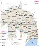
Agriculture is one of the main occupation of the people of Guntur. Paddy is among the major crops which is cultivated twice a year. Other crops that are grown are Jowar, Cotton, Turmeric, Maize, Arhar, Chillies, Sugarcane, and Sesame. The district is also involved in the mining of Limestone. The industries that contribute to the revenue of the state are Tobacco, Handloom, Silk, Sangam Dairy, Cement Factories at Thadepalli and Macherla, Andhra Fertilizers and Jute mill at Guntur. Durgistone craft is a popular handicraft of the region.
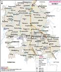
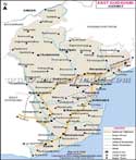
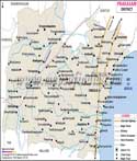
Water is supplied to the farming lands of Guntur from the Nagarjuna Sagar Right bank, Buckingham Canal of the Krishna Barrage, dam constructed across Naguleru river at Dachepalli. The district receives electricity through Nagarjuna Sagar Project and Machkand Project. Guntur is well connected by road and rail.It is an important railway junction of the Southern India. Pilgrimage Centers of Guntur are :
- Mangalagiri Panakala Swamy Temple, at Ponnuru
- Kotappakonda Temple, at Ponnuru
- Sri Anjaneya Swamy Temple at Ponnuru,
- Sri Laxmi Chennakesava Swamy Temple at Macherla,
- Temples at Amaravati, Tenali,
- Hinkar Thirtha Jain temple
- Phirangipuram Mary Matha Church.
- Kesanapalli Buddhist Centres
- Swamy Temple at Macherla
- Tenali Temples at Tenali
- Amaravati Museum
- Bapatla Beach(Suryalanka) Beaches
- Ethipothala Water falls, Nagarjunasagar
- Guthikonda Caves at Guthionda
- Kondaveedu Monumens
- Nagarjuna Sagar Dam
- Undavalli Cave Caves, Undavalli
- Uppalapadu Birds Sanctuary
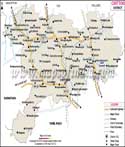
- From hyderabad 292 KM
- From delhi 1798 KM
- From chennai 396 KM
- From mumbai 1003 KM
- From bangalore 601 KM
- From pune 840 KM
Last Updated on : May 11, 2026